A fault line is a fracture or zone of fractures between two blocks of rock, where significant movement has occurred, often causing earthquakes. Understanding fault lines is crucial for assessing seismic risks and improving safety measures in vulnerable regions. Discover how fault lines impact the Earth's geology and what this means for Your safety in the full article.
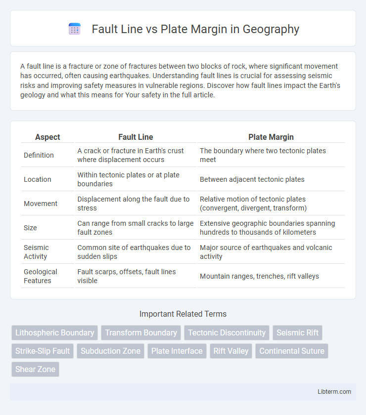
Table of Comparison
| Aspect | Fault Line | Plate Margin |
|---|---|---|
| Definition | A crack or fracture in Earth's crust where displacement occurs | The boundary where two tectonic plates meet |
| Location | Within tectonic plates or at plate boundaries | Between adjacent tectonic plates |
| Movement | Displacement along the fault due to stress | Relative motion of tectonic plates (convergent, divergent, transform) |
| Size | Can range from small cracks to large fault zones | Extensive geographic boundaries spanning hundreds to thousands of kilometers |
| Seismic Activity | Common site of earthquakes due to sudden slips | Major source of earthquakes and volcanic activity |
| Geological Features | Fault scarps, offsets, fault lines visible | Mountain ranges, trenches, rift valleys |
Introduction to Fault Lines and Plate Margins
Fault lines are fractures in the Earth's crust where blocks of rock have slipped past each other, typically associated with seismic activity. Plate margins, also known as tectonic boundaries, are zones where two or more tectonic plates meet and interact, causing earthquakes, volcanic activity, and mountain building. Understanding the differences between fault lines and plate margins is crucial for studying Earth's dynamic geological processes and predicting natural hazards.
Defining Fault Lines: Basic Concepts
Fault lines are fractures in the Earth's crust where blocks of rock have slipped past each other, creating zones of weakness. These geological features typically occur within tectonic plates and are distinct from plate margins, which are the boundaries between two tectonic plates. Understanding fault lines is crucial for assessing earthquake risks, as movement along these faults can release significant seismic energy.
Understanding Plate Margins: An Overview
Plate margins represent the boundaries where tectonic plates interact, classified into three main types: divergent, convergent, and transform margins. Fault lines, such as the San Andreas Fault, are specific fractures along transform plate margins where plates slide past each other, often causing earthquakes. Understanding these plate margins is essential for comprehending seismic activity and the dynamic nature of Earth's lithosphere.
Geological Processes at Fault Lines
Fault lines are fractures in the Earth's crust where tectonic plates move past each other, triggering seismic activity through stress accumulation and release. Plate margins, or boundaries, represent broader zones of interaction between tectonic plates, where divergent, convergent, or transform movements drive geological phenomena such as mountain building, volcanism, and earthquake generation. The geological processes at fault lines primarily involve slip, rupture, and displacement along narrow zones, concentrating strain and often causing significant ground shaking.
Types of Plate Margins and Their Features
Plate margins, or plate boundaries, are categorized into three primary types: divergent, convergent, and transform margins, each defined by unique geological features and movements. Divergent margins occur where tectonic plates move apart, creating new crust through volcanic activity and mid-ocean ridges, exemplified by the Mid-Atlantic Ridge. Convergent margins feature plates colliding, resulting in subduction zones, deep ocean trenches, and mountain ranges like the Himalayas, whereas transform margins involve lateral sliding of plates past one another, causing significant earthquake activity along faults such as the San Andreas Fault.
Key Differences: Fault Line vs Plate Margin
Fault lines are fractures in the Earth's crust where rocks on either side have moved relative to each other, typically occurring within tectonic plates. Plate margins, or boundaries, are zones where two tectonic plates meet and interact through processes like subduction, collision, or sliding past one another, often leading to significant geological activity. While fault lines can exist independently within plates, plate margins represent the larger-scale boundaries that drive major seismic and volcanic activity.
How Fault Lines Form vs Plate Margins
Fault lines form through the fracturing and displacement of Earth's crust due to stress accumulation, typically occurring within tectonic plates where the rock breaks and shifts. Plate margins, or plate boundaries, are zones where two tectonic plates meet and interact, leading to processes such as subduction, collision, or lateral sliding that shape geological features and generate seismic activity. The formation of fault lines is a result of localized brittle failure in the crust, whereas plate margins represent broader regions of tectonic stress and movement between entire plates.
Earthquake Activity: Fault Lines and Plate Margins
Fault lines are fractures in the Earth's crust where tectonic plates or blocks of rock move past each other, often generating localized earthquake activity. Plate margins, including divergent, convergent, and transform boundaries, are larger zones where significant tectonic interactions cause frequent and powerful earthquakes. Earthquake intensity and frequency tend to be higher along plate margins due to the accumulation and release of tectonic stress over extensive geological scales.
Global Examples: Notable Fault Lines and Plate Margins
The San Andreas Fault in California and the Alpine Fault in New Zealand are prominent examples of transform fault lines where tectonic plates slide past each other. The Himalayan Plate Margin, marking the collision between the Indian and Eurasian plates, exemplifies a convergent boundary responsible for significant mountain formation and seismic activity. Divergent plate margins such as the Mid-Atlantic Ridge showcase the creation of new oceanic crust through seafloor spreading, highlighting varied global manifestations of fault lines and plate margins.
Significance in Earth Science and Hazard Assessment
Fault lines are fractures in the Earth's crust where tectonic plates have slipped past each other, playing a critical role in understanding seismic activity and earthquake risks. Plate margins represent the boundaries between tectonic plates and are key zones of geological processes such as subduction, rifting, and mountain-building, which significantly influence volcanic eruptions and earthquake hazards. Accurate mapping and monitoring of fault lines and plate margins enhance hazard assessment by identifying areas prone to seismic events and informing disaster preparedness strategies.
Fault Line Infographic