Geodesy is the scientific discipline focused on measuring and understanding Earth's geometric shape, gravitational field, and rotation. It plays a crucial role in accurate mapping, satellite navigation, and monitoring tectonic movements. Discover how geodesy impacts your daily life and explore the latest advancements in this fascinating field in the rest of the article.
Table of Comparison
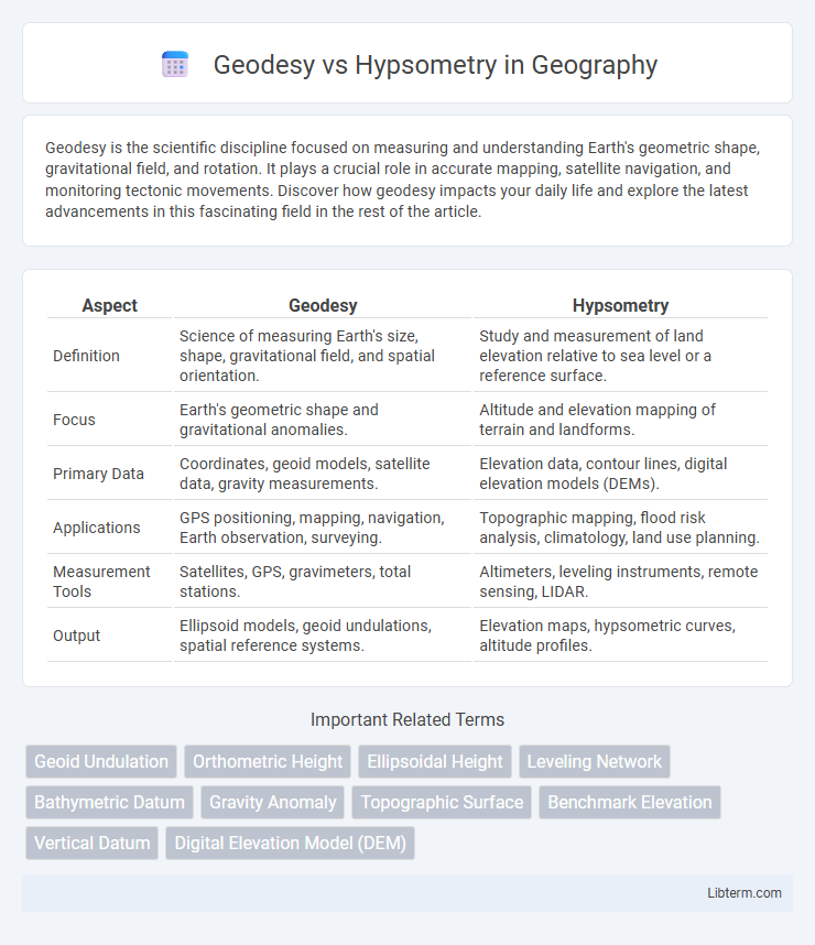
| Aspect | Geodesy | Hypsometry |
|---|---|---|
| Definition | Science of measuring Earth's size, shape, gravitational field, and spatial orientation. | Study and measurement of land elevation relative to sea level or a reference surface. |
| Focus | Earth's geometric shape and gravitational anomalies. | Altitude and elevation mapping of terrain and landforms. |
| Primary Data | Coordinates, geoid models, satellite data, gravity measurements. | Elevation data, contour lines, digital elevation models (DEMs). |
| Applications | GPS positioning, mapping, navigation, Earth observation, surveying. | Topographic mapping, flood risk analysis, climatology, land use planning. |
| Measurement Tools | Satellites, GPS, gravimeters, total stations. | Altimeters, leveling instruments, remote sensing, LIDAR. |
| Output | Ellipsoid models, geoid undulations, spatial reference systems. | Elevation maps, hypsometric curves, altitude profiles. |
Introduction to Geodesy and Hypsometry
Geodesy is the scientific discipline that measures and represents the Earth, including its gravitational field, in a three-dimensional time-varying space. Hypsometry, a subset of geodesy, specifically quantifies the measurement of land elevation relative to sea level. Both geodesy and hypsometry employ advanced satellite technology and geodetic reference systems to improve spatial accuracy and topographic mapping.
Defining Geodesy: Science of Earth Measurement
Geodesy is the science of measuring and understanding Earth's geometric shape, gravitational field, and spatial orientation, providing precise data for mapping and navigation. Hypsometry specifically focuses on measuring land elevation relative to sea level, aiding in topographic analysis and environmental studies. While geodesy encompasses a broad range of Earth measurement techniques, hypsometry serves as a specialized subset concerned with height determination.
What is Hypsometry? Understanding Elevation Measurement
Hypsometry is the scientific measurement of land elevation relative to sea level, crucial for creating topographic maps and understanding terrain features. Unlike geodesy, which involves the broader science of Earth's shape, gravity field, and spatial coordinates, hypsometry specifically quantifies height differences using methods such as leveling, barometric pressure readings, and satellite altimetry. Accurate hypsometric data supports applications in geology, environmental monitoring, and civil engineering by providing precise elevation benchmarks.
Historical Development of Geodesy and Hypsometry
Geodesy, originating in ancient Egypt and Greece, developed through the Renaissance with advancements by scholars like Eratosthenes, who first calculated Earth's circumference, and later Newton, who refined the geoid concept. Hypsometry emerged as a specialized branch of geodesy focusing on Earth's surface elevation measurements using leveling techniques and barometric pressure in the 18th and 19th centuries. The evolution of geodetic instruments such as the theodolite and advancements in satellite geodesy in the 20th century significantly enhanced the precision of hypsometric data.
Key Tools and Technologies in Geodesy
Geodesy employs advanced satellite systems like GPS, GNSS, and laser ranging to measure Earth's shape, gravity field, and spatial positioning with unparalleled precision. These technologies enable accurate monitoring of tectonic movements, sea-level rise, and geodynamic processes. In contrast, hypsometry primarily relies on topographic maps, digital elevation models (DEMs), and altimeters to assess elevation and terrain features.
Methods and Techniques Used in Hypsometry
Hypsometry primarily employs remote sensing techniques, photogrammetry, and digital elevation models (DEMs) to measure land elevation relative to sea level with high precision. Satellite altimetry and LiDAR scanning are also pivotal in generating accurate topographic maps and terrain models for hypsometric analysis. Geodesy, in contrast, uses geodetic surveying, GNSS (Global Navigation Satellite Systems), and gravity measurements to determine Earth's shape, orientation, and gravitational field, focusing on global spatial reference systems.
Core Differences Between Geodesy and Hypsometry
Geodesy focuses on measuring and understanding the Earth's shape, gravitational field, and spatial positioning through techniques like satellite geodesy and global positioning systems (GPS). Hypsometry centers on determining land elevation and terrain height relative to sea level, often utilizing contour maps and digital elevation models (DEMs). The core difference lies in geodesy's broader scope of Earth's geometric and gravitational properties versus hypsometry's specific emphasis on quantifying vertical land heights.
Applications of Geodesy in Modern Science
Geodesy plays a critical role in modern science by providing precise measurements of Earth's shape, gravitational field, and spatial positioning, essential for satellite navigation, climate monitoring, and earthquake prediction. Unlike hypsometry, which focuses on measuring land elevation relative to sea level, geodesy integrates data from GPS, satellite laser ranging, and gravity sensors to model the geoid and monitor tectonic movements. These applications support advancements in geophysics, environmental science, and aerospace engineering by enabling accurate spatial analysis and global positioning infrastructure.
Practical Uses of Hypsometry in Mapping and Surveying
Hypsometry provides precise measurements of elevation and landform heights, essential for topographic mapping and flood risk assessment. Surveyors rely on hypsometric data to create contour lines that accurately represent terrain variations, improving infrastructure planning and land use management. Geodesy complements these efforts by establishing accurate reference frames, but hypsometry offers detailed local elevation insights crucial for practical field applications.
Future Trends in Geodesy and Hypsometry
Future trends in geodesy emphasize the integration of satellite-based positioning systems like GNSS and advancements in InSAR technology for precise Earth surface monitoring. Hypsometry's evolution focuses on high-resolution digital elevation models (DEMs) derived from LiDAR and UAV surveys to improve terrain analysis and modeling. The convergence of geodesy and hypsometry using AI-driven data processing and real-time geospatial analytics is set to enhance environmental monitoring and disaster management capabilities.
Geodesy Infographic