Meanders are natural curves or bends found in rivers and streams, formed by the water's erosion and deposition processes. These winding paths influence the surrounding landscape, creating diverse habitats and affecting flood dynamics. Explore the rest of this article to learn how meanders shape ecosystems and impact your environment.
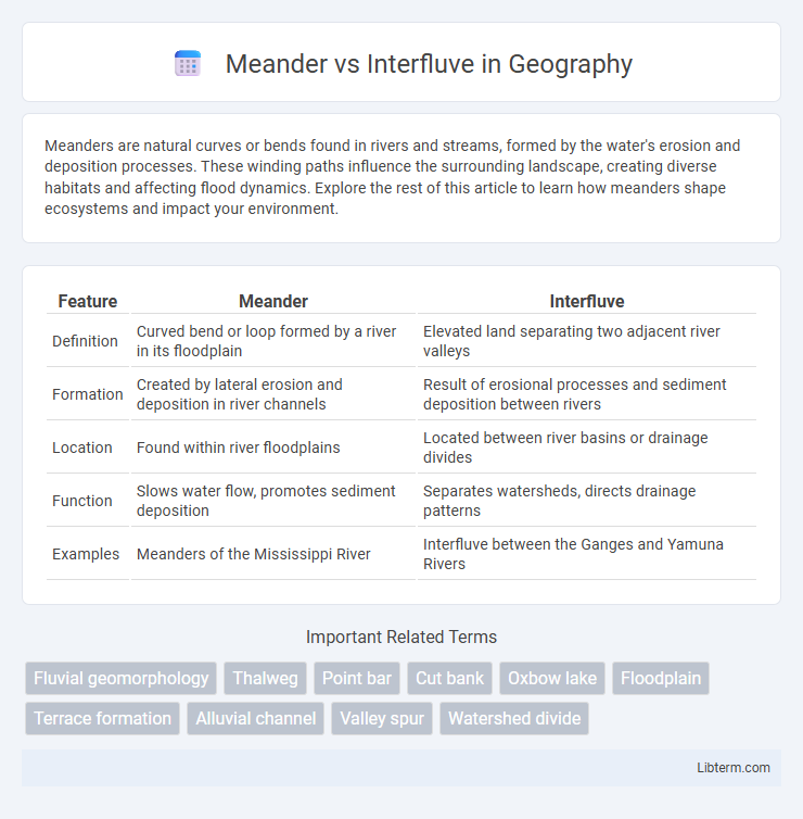
Table of Comparison
| Feature | Meander | Interfluve |
|---|---|---|
| Definition | Curved bend or loop formed by a river in its floodplain | Elevated land separating two adjacent river valleys |
| Formation | Created by lateral erosion and deposition in river channels | Result of erosional processes and sediment deposition between rivers |
| Location | Found within river floodplains | Located between river basins or drainage divides |
| Function | Slows water flow, promotes sediment deposition | Separates watersheds, directs drainage patterns |
| Examples | Meanders of the Mississippi River | Interfluve between the Ganges and Yamuna Rivers |
Introduction to Meanders and Interfluves
Meanders are winding curves or bends found in mature river channels, formed by lateral erosion and deposition processes driven by water flow dynamics. Interfluves are elevated landforms or ridges situated between adjacent river valleys, often representing remnants of older, more resistant terrain. Understanding the contrasting geomorphological features and formation mechanisms of meanders and interfluves is essential for studying fluvial landscapes and drainage patterns.
Definition of Meander
A meander is a winding curve or bend in a river, formed as the water erodes the outer banks and deposits sediment along the inner banks, creating a sinuous path. In contrast, an interfluve refers to the higher land or ridge that separates adjacent river valleys. Understanding meanders is crucial for studying river dynamics, sediment transport, and floodplain development.
Definition of Interfluve
An interfluve is a landform representing the higher terrain or ridge of land that lies between two adjacent river valleys or drainage basins. It functions as a natural divide that channels water flow into separate river systems, contrasting with meanders, which are winding curves or bends typically found within a single river channel. Interfluves play a critical role in watershed management by directing surface runoff and influencing regional hydrology.
Key Differences between Meander and Interfluve
Meanders are winding curves or bends in a river formed by erosion and deposition processes within the river channel, typically found in mature river stages. Interfluves are the higher land areas or ridges that separate adjacent river valleys, formed primarily through long-term geomorphological processes like erosion and tectonic activity. The key difference lies in their spatial location and function: meanders occur within the river course influencing water flow and sediment transport, while interfluves define drainage divides and influence watershed boundaries.
Formation Processes of Meanders
Meanders form through the dynamic process of lateral erosion and deposition caused by water flow in rivers, where velocity varies across the channel, eroding the outer banks and depositing sediments on the inner curves. This continuous erosion and deposition cycle leads to the characteristic sinuous bends of a meander. In contrast, interfluves are elevated landforms formed by the erosion of adjacent valleys, representing the ridges between river channels rather than active river bends.
Formation Processes of Interfluves
Interfluves form through processes of soil erosion and deposition between adjacent river valleys, where elevated land persists as lower areas are carved by fluvial activity. These geomorphological features result from differential erosion rates, sediment transport, and varying water flow that shape the landscape between meandering river channels. Understanding interfluve formation involves analyzing factors like rainfall patterns, vegetation cover, and underlying geological structures that influence surface runoff and soil stability.
Geographical Significance of Meanders
Meanders are sinuous bends in a river formed by lateral erosion and deposition, playing a crucial role in shaping floodplains and influencing sediment distribution. They contribute to the creation of diverse aquatic habitats and determine the course and dynamics of river systems. In contrast, an interfluve is the higher land or ridge separating adjacent valleys or river basins, affecting watershed boundaries and drainage patterns but lacking the active sedimentary processes seen in meanders.
Role of Interfluves in Landscape Evolution
Interfluves serve as critical geomorphological features influencing landscape evolution by acting as elevated ridges that separate adjacent river valleys and meanders, thus controlling sediment distribution and drainage patterns. Their stability affects erosion rates and soil development, shaping the spatial organization of fluvial systems and directing water flow away from valley floors to sustain watershed dynamics. Interfluves also provide ecological niches and influence vegetation patterns, further contributing to landscape heterogeneity and long-term geomorphic processes.
Meander and Interfluve: Examples Worldwide
Meanders are winding bends in rivers commonly found in the Mississippi River in the USA and the Amazon River in South America, showcasing natural river curvature that influences erosion and deposition patterns. Interfluves are elevated landforms located between adjacent river valleys, like the Deccan Plateau in India and the Cote d'Or region in France, serving as important geographic separators influencing watershed boundaries. Both features illustrate key fluvial landforms that shape landscapes and impact regional hydrology globally.
Conclusion: Comparing Meanders and Interfluves
Meanders are dynamic, curved river bends formed by erosion and deposition processes along watercourses, while interfluves are elevated land areas situated between adjacent river valleys. Meanders play a significant role in shaping floodplains and influencing sediment transport, whereas interfluves contribute to watershed boundaries and influence drainage patterns. Understanding the distinctions between meanders and interfluves is essential for effective watershed management, land use planning, and interpreting fluvial geomorphology.
Meander Infographic