Vector features represent geographic elements using points, lines, and polygons to precisely map real-world objects such as roads, boundaries, and landmarks. This method supports detailed spatial analysis and accurate data visualization, essential for GIS applications and digital mapping. Explore the full article to understand how leveraging vector features can enhance your geospatial projects.
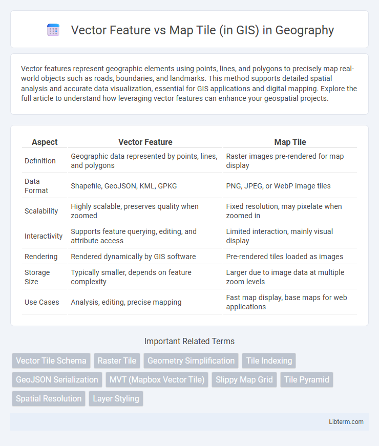
Table of Comparison
| Aspect | Vector Feature | Map Tile |
|---|---|---|
| Definition | Geographic data represented by points, lines, and polygons | Raster images pre-rendered for map display |
| Data Format | Shapefile, GeoJSON, KML, GPKG | PNG, JPEG, or WebP image tiles |
| Scalability | Highly scalable, preserves quality when zoomed | Fixed resolution, may pixelate when zoomed in |
| Interactivity | Supports feature querying, editing, and attribute access | Limited interaction, mainly visual display |
| Rendering | Rendered dynamically by GIS software | Pre-rendered tiles loaded as images |
| Storage Size | Typically smaller, depends on feature complexity | Larger due to image data at multiple zoom levels |
| Use Cases | Analysis, editing, precise mapping | Fast map display, base maps for web applications |
Understanding Vector Features in GIS
Vector features in GIS represent geographic data through discrete geometric shapes such as points, lines, and polygons, enabling precise spatial analysis and attribute association. These features store real-world entities like roads, boundaries, and landmarks with high accuracy and scalability, supporting dynamic querying and editing. Unlike raster-based map tiles, vector features allow for improved customization, resolution independence, and efficient data management in GIS applications.
The Basics of Map Tiles Explained
Map tiles are pre-rendered images divided into a grid, allowing quick map display by loading only visible sections, enhancing performance and scalability in GIS applications. In contrast, vector features represent geographical elements as geometric shapes and attribute data, enabling dynamic styling and interactivity. Map tiles excel in fast, consistent map rendering, while vector features offer detailed customization and precise spatial analysis.
Key Differences Between Vector Features and Map Tiles
Vector features in GIS represent spatial data using points, lines, and polygons defined by precise coordinates, enabling high accuracy and dynamic styling at various zoom levels. Map tiles consist of pre-rendered raster images that display spatial information as fixed grid cells, optimized for fast loading but limited in interactivity and scalability. Vector data supports detailed analysis and real-time updates, whereas map tiles prioritize efficient map rendering and bandwidth reduction.
Data Storage and Management Approaches
Vector features store geographic data as discrete points, lines, and polygons representing real-world entities with precise geometry and attributes, enabling efficient querying and editing. Map tiles break geographic data into pre-rendered raster images organized in a grid system, optimizing fast map visualization and reducing server load but limiting dynamic data manipulation. Vector data demands more complex storage solutions like spatial databases (e.g., PostGIS) for attribute indexing and transactions, whereas map tiles rely on tile caching mechanisms and distributed file systems to manage large-scale, scalable map delivery.
Rendering Techniques: Vector vs. Tile-Based Mapping
Vector features in GIS leverage rendering techniques that dynamically draw geometries and attributes on the client side, allowing for smooth scaling, precise styling, and interactive editing without loss of detail. Tile-based mapping relies on pre-rendered raster images or map tiles that load quickly and efficiently, optimizing performance for large datasets but limiting real-time interactivity and style customization. Vector rendering benefits applications requiring high customization and detail fidelity, while tile-based approaches serve better for fast, consistent display of large-scale maps.
Scalability and Performance Considerations
Vector features enable high scalability by allowing dynamic rendering and styling on the client side, reducing server load and bandwidth usage compared to map tiles. Map tiles pre-render spatial data as raster images, offering faster initial load times but potentially increasing storage requirements and less flexibility in customization. Performance in large-scale GIS applications often favors vector data for interactive and zoom-level adaptable maps, while map tiles excel in environments demanding quick, consistent visual outputs with minimal client-side processing.
Customization and Styling Capabilities
Vector features in GIS offer extensive customization and styling capabilities, enabling precise control over individual elements such as points, lines, and polygons with dynamic attributes and interactive behaviors. Map tiles, typically raster images, provide limited styling options since they are pre-rendered, making real-time customization or dynamic updates challenging. Vector data supports scalable, resolution-independent visuals, allowing seamless adjustments to style properties like color, opacity, and labeling without loss of quality.
Use Cases for Vector Features in GIS
Vector features in GIS are ideal for use cases requiring high accuracy and detailed attribute data, such as urban planning, utility management, and cadastral mapping. They enable precise spatial queries, editing, and analysis of points, lines, and polygons critical for infrastructure design and environmental monitoring. Unlike map tiles, vector features support dynamic styling and real-time data updates, enhancing interactive mapping applications and decision-making processes.
Real-World Applications of Map Tiles
Map tiles enable fast, scalable rendering of geographic data by pre-rendering map images at various zoom levels, which is crucial for applications requiring seamless user experiences, such as web mapping services and mobile navigation apps. They allow efficient display of complex spatial data without overwhelming client devices, supporting high traffic and interactive zooming in platforms like Google Maps and OpenStreetMap. Map tiles are particularly advantageous in disaster management and urban planning where rapid, high-resolution map visualization is essential for decision-making and situational awareness.
Choosing the Right Approach: Vector Feature or Map Tile?
Choosing the right approach between vector features and map tiles in GIS depends on the application's needs for interactivity, styling flexibility, and performance. Vector features enable dynamic updates, detailed attribute queries, and scalable rendering ideal for data-rich, interactive maps, while map tiles provide fast loading and consistent display, especially suitable for base maps and large-scale datasets. Balancing factors like bandwidth, client processing power, and desired user experience guides the optimal selection between these two methods.
Vector Feature Infographic