GIS transforms raw geographic data into detailed maps that reveal spatial patterns and relationships critical for decision-making. Cartography enhances this process by applying design principles to create clear, visually engaging maps that communicate complex information effectively. Explore the rest of the article to discover how integrating GIS and cartography can empower your spatial analysis projects.
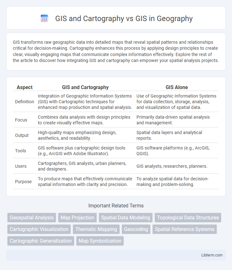
Table of Comparison
| Aspect | GIS and Cartography | GIS Alone |
|---|---|---|
| Definition | Integration of Geographic Information Systems (GIS) with Cartographic techniques for enhanced map production and spatial analysis. | Use of Geographic Information Systems for data collection, storage, analysis, and visualization of spatial data. |
| Focus | Combines data analysis with design principles to create visually effective maps. | Primarily data-driven spatial analysis and management. |
| Output | High-quality maps emphasizing design, aesthetics, and readability. | Spatial data layers and analytical reports. |
| Tools | GIS software plus cartographic design tools (e.g., ArcGIS with Adobe Illustrator). | GIS software platforms (e.g., ArcGIS, QGIS). |
| Users | Cartographers, GIS analysts, urban planners, and designers. | GIS analysts, researchers, planners. |
| Purpose | To produce maps that effectively communicate spatial information with clarity and precision. | To analyze spatial data for decision-making and problem-solving. |
Understanding GIS: Foundations and Functions
GIS integrates spatial data analysis with cartography to visualize geographic patterns effectively. Understanding GIS involves grasping its core functions such as data capture, storage, manipulation, and spatial analysis, which enable precise map creation. While cartography focuses on the art and science of map design, GIS provides the technological foundation for dynamic spatial data management and decision-making.
The Evolution of Cartography in the Digital Era
The evolution of cartography in the digital era has transformed traditional map-making into dynamic Geographic Information Systems (GIS) platforms, enabling precise spatial analysis and real-time data visualization. Modern GIS integrates digital cartographic techniques, allowing for layered mapping, interactive features, and the incorporation of vast datasets such as satellite imagery and demographic statistics. This advancement has revolutionized fields like urban planning, environmental monitoring, and disaster management by providing more accurate and accessible geographic information than conventional cartography.
GIS and Cartography: Interconnected Disciplines
GIS and cartography are interconnected disciplines essential for spatial data analysis and visualization. Cartography focuses on the art and science of map-making, while GIS integrates data collection, storage, and spatial analysis to support informed decision-making. The synergy between GIS technology and cartographic principles enhances the accuracy, clarity, and effectiveness of geographic representations.
Key Differences: GIS Alone vs. GIS with Cartography
GIS alone primarily involves the collection, analysis, and management of spatial data using software tools capable of handling geographic information systems. GIS with cartography integrates advanced map design principles, enhancing the visualization and interpretability of spatial data through well-crafted, aesthetically appealing maps. This combination improves decision-making by transforming raw GIS data into user-friendly, meaningful cartographic representations.
The Role of Visualization in GIS and Cartography
Visualization plays a crucial role in both GIS and cartography by transforming spatial data into intuitive, interpretable maps that enhance decision-making. GIS leverages advanced visualization techniques such as 3D modeling, interactive maps, and real-time data layers to provide dynamic insights, while traditional cartography emphasizes aesthetic design and clear symbolization for effective communication. The integration of visualization tools within GIS improves spatial analysis accuracy, allowing users to detect patterns, trends, and relationships that are essential for urban planning, environmental management, and resource allocation.
Data Accuracy and Representation: Mapping Matters
GIS technology enhances data accuracy by integrating real-time geographic data with advanced spatial analysis tools, surpassing traditional cartography's static map representations. Cartography emphasizes visual design and spatial communication, ensuring maps are both accurate and easily interpreted by users. Accurate GIS data representation underpins critical decision-making in urban planning, environmental management, and navigation systems.
Practical Applications: GIS vs. GIS with Cartographic Techniques
GIS harnesses spatial data analysis for applications like urban planning, environmental monitoring, and resource management, emphasizing data accuracy and geospatial modeling. Incorporating cartographic techniques into GIS enhances visual communication by producing intuitive maps that improve data interpretation and decision-making. This integration supports fields such as emergency response, transportation logistics, and public health by transforming raw spatial data into accessible, actionable insights.
Software and Tools: Cartographic Enhancements in GIS
GIS integrates advanced cartographic software such as ArcGIS Pro and QGIS to enhance map visualization through dynamic symbology, labeling, and spatial analysis tools. These cartographic enhancements enable precise data representation and customization, improving map readability and user interaction. Unlike traditional cartography, GIS software supports real-time data updates and multilayered map composition, facilitating comprehensive spatial decision-making.
Skills Required: Cartographer vs. GIS Analyst
Cartographers require strong skills in map design, spatial visualization, and artistic abilities to create accurate and aesthetically pleasing maps, emphasizing graphical representation and storytelling through geography. GIS Analysts need proficiency in spatial data analysis, database management, and GIS software such as ArcGIS or QGIS to interpret complex datasets and generate actionable insights for decision-making. Both roles demand knowledge of geography and spatial concepts, but Cartographers focus more on visual communication skills, while GIS Analysts prioritize technical and analytical expertise.
Future Trends: Integrating Cartography in GIS Development
Future trends in GIS emphasize the seamless integration of cartography principles to enhance spatial data visualization and user experience. Advanced techniques like 3D mapping, real-time data rendering, and interactive map design are increasingly embedded within GIS platforms to improve decision-making accuracy. This convergence promotes more intuitive geospatial analysis tools, facilitating broader accessibility and more precise environmental and urban planning outcomes.
GIS and Cartography Infographic