An isohyet is a line drawn on a map connecting points of equal rainfall. This concept is crucial for meteorologists and hydrologists in analyzing precipitation patterns and planning water resource management. Explore the article to understand how isohyets aid in predicting weather and managing your environment effectively.
Table of Comparison
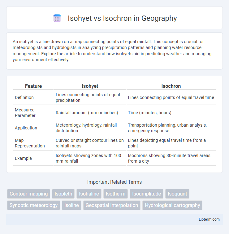
| Feature | Isohyet | Isochron |
|---|---|---|
| Definition | Lines connecting points of equal precipitation | Lines connecting points of equal travel time |
| Measured Parameter | Rainfall amount (mm or inches) | Time (minutes, hours) |
| Application | Meteorology, hydrology, rainfall distribution | Transportation planning, urban analysis, emergency response |
| Map Representation | Curved or straight contour lines on rainfall maps | Lines depicting equal travel time from a point |
| Example | Isohyets showing zones with 100 mm rainfall | Isochrons showing 30-minute travel areas from a city |
Introduction to Isohyet and Isochron
Isohyet refers to a line on a map that connects points of equal precipitation, essential for meteorological and hydrological studies to analyze rainfall distribution. Isochron is a line connecting points of equal travel time to a specific location, widely used in transportation planning and emergency response. Understanding the distinction between isohyets and isochrons helps optimize resource management and improve spatial analysis across various fields.
Defining Isohyet: Meaning and Importance
Isohyet refers to a contour line on a map connecting points that receive equal amounts of precipitation over a specific period, crucial for meteorological analysis and water resource management. This line helps visualize spatial rainfall distribution, aiding in agricultural planning, flood control, and environmental monitoring. Understanding isohyets enhances precision in weather forecasting and climate studies by mapping precipitation intensity and patterns.
Defining Isochron: Meaning and Importance
Isochron refers to a line on a map connecting points where an event occurs simultaneously or where travel time to a specific location is equal. It plays a crucial role in fields like transportation planning, emergency response, and urban development by helping visualize accessibility and temporal relationships. Understanding isochrons enables efficient resource allocation and improved decision-making based on synchronized timing or travel duration data.
Key Differences Between Isohyet and Isochron
Isohyets represent lines of equal rainfall on a map, crucial for understanding spatial precipitation distribution and water resource management. Isochrons connect points of equal travel time, essential in transportation planning and seismic wave analysis. The key difference lies in their measured variables: isohyets map precipitation intensity, while isochrons depict temporal data related to movement or signal propagation.
Applications of Isohyets in Meteorology
Isohyets are lines connecting points of equal rainfall, crucial for analyzing precipitation distribution and planning water resource management in meteorology. These contours help meteorologists assess drought conditions, predict flood risks, and design efficient irrigation systems by mapping spatial rainfall variations accurately. Isochrones, in contrast, link points of equal travel time and are mainly used in transportation and emergency response planning rather than meteorological applications.
Applications of Isochrons in Geology
Isochrons in geology are critical for determining the age of rock formations and understanding geological time scales through radiometric dating techniques. By mapping isochrons, geologists can trace the timing of tectonic events, sediment deposition, and metamorphic processes with precision. These applications enhance the reconstruction of Earth's geological history and the correlation of stratigraphic layers across different regions.
Data Collection Methods for Isohyets
Isohyets represent lines of equal precipitation and are derived from data collected using rain gauges strategically placed across geographic regions to measure rainfall intensity over specific time periods. The accuracy of isohyet mapping depends on the density and spatial distribution of these gauges, often supplemented by remote sensing technologies such as radar and satellite imagery to enhance spatial resolution. This precipitation data is then interpolated using geostatistical methods like kriging or inverse distance weighting to generate continuous isohyet contours that reflect spatial rainfall patterns.
Data Interpretation Techniques for Isochrons
Isochrons represent lines connecting points of equal travel time, crucial for seismic data interpretation and velocity model calibration. Data interpretation techniques for isochrons involve analyzing travel time curves, applying tomographic inversion, and integrating seismic wave velocities to enhance subsurface imaging accuracy. Precise interpretation of isochrons supports determining seismic event timings, structural layering, and improving hazard assessment models.
Visual Representation: Mapping Isohyets vs Isochrons
Isohyets are represented as contour lines on maps connecting points of equal precipitation, providing visual insight into rainfall distribution patterns over a geographic area. Isochrons, on the other hand, map lines of equal travel time from a specific point, illustrating temporal spatial relationships for events like seismic waves or evacuation routes. These visual representations assist meteorologists and planners in analyzing spatial variability in precipitation through isohyets and temporal dynamics using isochrons.
Summary: Choosing Isohyet or Isochron for Your Study
ISOHYETS represent lines of equal rainfall distribution, essential for hydrological studies, water resource management, and climate analysis. ISOCHRONS depict lines of equal travel time, crucial for transport planning, emergency response, and urban mobility assessments. Selecting between isohyet and isochron depends on whether your study prioritizes spatial precipitation patterns or temporal accessibility metrics.
Isohyet Infographic