Mesoclimate refers to the climate of a specific area that is smaller than a region but larger than a microclimate, often influenced by factors like topography, vegetation, and nearby water bodies. Understanding mesoclimate is crucial for agriculture, urban planning, and environmental management as it affects local weather patterns and ecological conditions. Explore the rest of the article to discover how mesoclimate impacts your environment and decision-making processes.
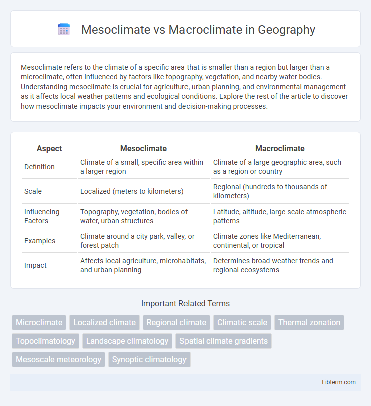
Table of Comparison
| Aspect | Mesoclimate | Macroclimate |
|---|---|---|
| Definition | Climate of a small, specific area within a larger region | Climate of a large geographic area, such as a region or country |
| Scale | Localized (meters to kilometers) | Regional (hundreds to thousands of kilometers) |
| Influencing Factors | Topography, vegetation, bodies of water, urban structures | Latitude, altitude, large-scale atmospheric patterns |
| Examples | Climate around a city park, valley, or forest patch | Climate zones like Mediterranean, continental, or tropical |
| Impact | Affects local agriculture, microhabitats, and urban planning | Determines broad weather trends and regional ecosystems |
Introduction to Mesoclimate and Macroclimate
Mesoclimate refers to the climate of a specific area within a region, typically spanning several kilometers, influenced by local features such as terrain, vegetation, and bodies of water. Macroclimate covers a broader geographic scale, encompassing regional or national climate patterns shaped by large-scale atmospheric and oceanic processes. Understanding both mesoclimate and macroclimate is essential for accurate environmental assessment, agriculture planning, and climate adaptation strategies.
Defining Mesoclimate: Key Characteristics
Mesoclimate refers to the climate of a specific area ranging from a few square kilometers to several hundred, positioned between microclimate and macroclimate scales. Key characteristics of mesoclimate include distinct variations in temperature, humidity, wind patterns, and precipitation influenced by local topography, vegetation, and urban structures. Unlike macroclimate, which covers larger regions or continents, mesoclimate captures localized atmospheric conditions that impact agriculture, forestry, and urban planning.
Understanding Macroclimate: Broad Scale Influences
Macroclimate encompasses large-scale atmospheric patterns influencing regional weather and temperature trends, shaped by factors like latitude, altitude, and proximity to oceans. It determines the general climate characteristics over extensive geographic areas, typically spanning hundreds of kilometers. This broad climate framework sets the foundation upon which smaller-scale mesoclimate variations occur.
Spatial and Temporal Scales: Mesoclimate vs Macroclimate
Mesoclimate refers to the climate of a specific, localized area, typically spanning spatial scales from a few hundred meters to several kilometers and temporal scales ranging from days to years, influencing microhabitats like urban zones or forest clearings. Macroclimate encompasses broader regions such as continents or countries, covering spatial extents from hundreds to thousands of kilometers with temporal scales extending over decades to centuries, shaping large-scale weather patterns and ecosystems. Understanding the distinctions in spatial and temporal scales between mesoclimate and macroclimate is crucial for regional climate modeling, agriculture planning, and ecological conservation.
Factors Influencing Mesoclimate
Mesoclimate refers to the climatic conditions of a specific area within the larger macroclimate, typically influenced by localized factors such as topography, vegetation, water bodies, and urban structures. Variations in elevation, slope aspect, and proximity to forests or lakes create distinct temperature and humidity patterns, shaping the mesoclimate uniquely from the surrounding macroclimate. These factors cause micro-scale climatic variations that affect agriculture, biodiversity, and human comfort within the mesoclimate zone.
Determinants of Macroclimate Patterns
Macroclimate patterns are primarily determined by large-scale factors such as latitude, altitude, prevailing wind systems, ocean currents, and proximity to large water bodies, which influence temperature and precipitation on regional and continental scales. These elements shape long-term weather patterns and climate zones by controlling solar radiation distribution and atmospheric circulation. In contrast, mesoclimate conditions emerge from localized influences such as topography, vegetation cover, and urban structures, causing micro-variations within the broader macroclimate framework.
Mesoclimate and Macroclimate: Real-World Examples
Mesoclimate refers to the climate of a specific local area, such as a valley or hillside, which can differ significantly from the broader regional climate known as macroclimate. For example, a vineyard on a South-facing slope may experience a warmer mesoclimate than the surrounding macroclimate of the larger region it belongs to. Urban heat islands also exemplify mesoclimate effects within the macroclimate of a metropolitan area, showing localized temperature increases due to human activities.
Impacts on Agriculture and Ecosystems
Mesoclimate influences agriculture and ecosystems by creating localized variations in temperature, humidity, and wind patterns within a specific area, often affecting crop yields, pest populations, and soil moisture levels. Macroclimate, encompassing broader regional climate conditions, shapes large-scale agricultural zones and ecosystem distributions by determining overall temperature ranges, precipitation patterns, and seasonal cycles. Understanding the interaction between mesoclimate and macroclimate is essential for optimizing land use, improving crop resilience, and managing biodiversity in varying climatic conditions.
Climate Monitoring and Measurement Techniques
Mesoclimate refers to localized climate conditions within a distinct geographic area, often measured using dense networks of microclimate stations equipped with high-resolution sensors for temperature, humidity, and wind speed. Macroclimate encompasses broader regional climate patterns, monitored through large-scale climate models, satellite remote sensing, and synoptic weather stations collecting extensive atmospheric data. Accurate climate monitoring necessitates integrating detailed mesoclimate measurements with macroclimate datasets to enhance the precision of climate models and improve localized weather predictions.
Summary: Comparing Mesoclimate and Macroclimate
Mesoclimate refers to the climate of a specific area ranging from a few kilometers to several tens of kilometers, influenced by local geographic features such as hills, valleys, and water bodies. Macroclimate covers larger regions or entire countries, shaped by broader atmospheric patterns and global climate systems. Understanding the differences between mesoclimate and macroclimate is essential for applications in agriculture, urban planning, and environmental management.
Mesoclimate Infographic