Globes offer a three-dimensional representation of Earth, providing accurate depictions of continents, oceans, and geopolitical boundaries. They serve as essential educational tools for understanding global geography and spatial relationships. Explore the rest of this article to discover how a globe can enhance your geographical knowledge and spatial awareness.
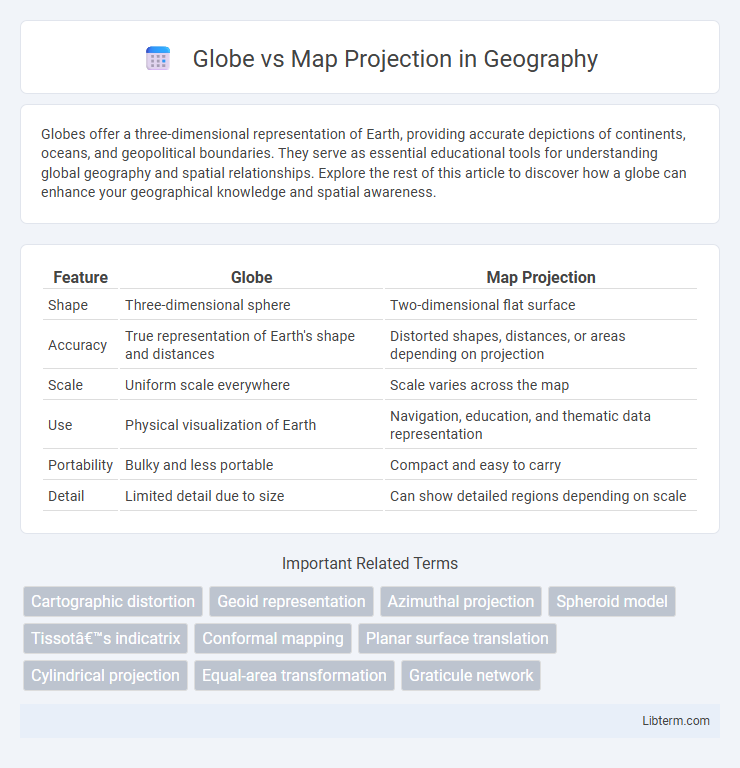
Table of Comparison
| Feature | Globe | Map Projection |
|---|---|---|
| Shape | Three-dimensional sphere | Two-dimensional flat surface |
| Accuracy | True representation of Earth's shape and distances | Distorted shapes, distances, or areas depending on projection |
| Scale | Uniform scale everywhere | Scale varies across the map |
| Use | Physical visualization of Earth | Navigation, education, and thematic data representation |
| Portability | Bulky and less portable | Compact and easy to carry |
| Detail | Limited detail due to size | Can show detailed regions depending on scale |
Introduction to Globes and Map Projections
Globes provide a three-dimensional, accurate representation of Earth's surface, preserving the true scale, shape, and spatial relationships of continents and oceans. Map projections transform the spherical Earth onto a two-dimensional plane, which introduces distortions in area, shape, distance, or direction depending on the projection type, such as Mercator, Robinson, or Azimuthal. Understanding the differences between globes and various map projections is essential for accurately interpreting geographic data and spatial relationships in cartography.
What Is a Globe?
A globe is a three-dimensional, spherical representation of the Earth that accurately displays continents, oceans, and geographic features in true proportions and relative positions. Unlike flat map projections, a globe preserves the Earth's curvature, minimizing distortion of distance, area, and shape. Globes serve as essential tools for visualizing global geography, providing a realistic spatial understanding of the planet's surface.
Understanding Map Projections
Globe represents the Earth's true three-dimensional shape, preserving accurate distances, directions, and areas, while map projections transform this curved surface onto a flat plane, inevitably causing distortions. Different types of map projections, such as Mercator, Robinson, and Winkel Tripel, prioritize preserving various spatial properties like shape, area, or distance depending on their intended use. Understanding map projections is essential for interpreting geographic data accurately, as each projection affects the representation of continents and spatial relationships differently.
Types of Map Projections
Map projections transform the three-dimensional Earth onto a two-dimensional surface, each type addressing specific distortions in area, shape, distance, or direction. Common types include cylindrical projections like Mercator, ideal for navigation due to straight rhumb lines, but with area distortion near poles; conic projections such as Albers Equal-Area, preserving area and suited for mid-latitude regions; and azimuthal projections like the stereographic, maintaining accurate directions from a central point. Understanding these projection types enables informed choices based on the map's purpose, balancing trade-offs between spatial properties on a flat representation of the globe.
Accuracy: Globe vs. Map Projection
Globes provide the most accurate representation of Earth's surface by preserving true distances, directions, and areas without distortion, unlike map projections that inherently distort these properties to display the 3D globe on a 2D surface. Common map projections, such as Mercator or Robinson, compromise accuracy by stretching or compressing continents and ocean sizes to fit flat maps. Consequently, globes remain the preferred tool for precise geographic measurements and visualizing Earth's actual spatial relationships.
Distortions in Map Projections
Map projections inevitably introduce distortions because they transform the three-dimensional surface of a globe onto a two-dimensional plane. These distortions affect shapes, areas, distances, or directions, depending on the type of projection used, such as Mercator, Robinson, or Peters. Understanding these projection-specific distortions helps cartographers select the most appropriate map for navigation, thematic representation, or spatial analysis.
Usability and Practical Applications
Globes provide a true-to-scale representation of Earth's surface, preserving accurate distances, shapes, and areas, which makes them ideal for educational purposes and understanding global geography. Maps, created through various projection techniques, allow for flat, portable, and detailed views of specific regions, making them essential tools for navigation, urban planning, and thematic analysis such as climate or population density studies. Despite inherent distortions in map projections like Mercator or Robinson, their versatility and ease of use make them indispensable in fields requiring spatial data visualization and route optimization.
Advantages of Using a Globe
Globes provide an accurate three-dimensional representation of Earth, preserving true scale, distances, and spatial relationships without distortion. They offer a realistic visualization of continents, oceans, and the curvature of the planet, enabling precise understanding of global geography. Unlike flat map projections, globes avoid the distortions in area, shape, and direction, which are common in two-dimensional representations.
Benefits and Limitations of Map Projections
Map projections transform the three-dimensional Earth onto a two-dimensional surface, enabling detailed study and easy transportation of geographic data. They offer practical benefits like customizable scales and the ability to emphasize specific regions or features, essential for navigation, education, and thematic mapping. However, map projections inevitably introduce distortions in area, shape, distance, or direction, meaning no single projection perfectly represents the globe's surface without some trade-offs in accuracy.
Choosing Between a Globe and a Map Projection
Choosing between a globe and a map projection depends on the need for accuracy and usability; globes provide a true representation of Earth's spherical shape, preserving accurate distances and proportions. Map projections, such as Mercator or Robinson, translate the globe onto a flat surface, making them more practical for navigation and spatial analysis but often introducing distortions in area, shape, or scale. Selecting the appropriate tool requires balancing the precision of a globe with the convenience and specific purpose of various map projections.
Globe Infographic