Understanding map orientation is essential for accurately interpreting geographic information and navigating unfamiliar areas. By aligning the map with cardinal directions, you ensure that your position and route correspond correctly to real-world locations. Explore the article to master map orientation techniques and enhance your navigation skills.
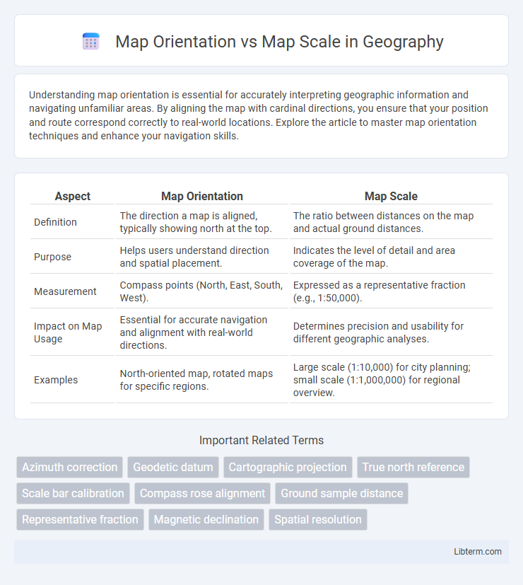
Table of Comparison
| Aspect | Map Orientation | Map Scale |
|---|---|---|
| Definition | The direction a map is aligned, typically showing north at the top. | The ratio between distances on the map and actual ground distances. |
| Purpose | Helps users understand direction and spatial placement. | Indicates the level of detail and area coverage of the map. |
| Measurement | Compass points (North, East, South, West). | Expressed as a representative fraction (e.g., 1:50,000). |
| Impact on Map Usage | Essential for accurate navigation and alignment with real-world directions. | Determines precision and usability for different geographic analyses. |
| Examples | North-oriented map, rotated maps for specific regions. | Large scale (1:10,000) for city planning; small scale (1:1,000,000) for regional overview. |
Understanding Map Orientation
Map orientation refers to the alignment of a map in relation to geographic directions, typically indicating north at the top to help users accurately interpret spatial relationships. Understanding map orientation is crucial for navigation, ensuring that landmarks and routes correspond correctly to real-world directions. Unlike map scale, which quantifies the ratio between distances on the map and actual distances on the ground, orientation focuses on directional accuracy and spatial alignment.
Defining Map Scale
Map scale defines the relationship between distances on a map and their corresponding real-world measurements, expressed as a ratio or fraction such as 1:50,000. It determines the level of detail visible, influencing how much area is covered and how features are represented. Understanding map scale is essential for accurately interpreting distances, sizes, and spatial relationships on any cartographic representation.
Key Differences: Orientation vs. Scale
Map orientation refers to the directional alignment of the map relative to the Earth's geographic directions, typically indicated by a compass rose showing north, south, east, and west. Map scale represents the ratio between distances on the map and actual ground distances, expressed as a representative fraction or graphic scale bar, determining the level of detail and area covered. Orientation affects navigation and spatial understanding, while scale influences accuracy and the extent of geographical features displayed.
Importance of Accurate Map Orientation
Accurate map orientation is crucial for effective navigation, ensuring users align the map correctly with their surroundings for precise direction finding. Unlike map scale, which determines the level of detail and distance representation, orientation directly influences the user's spatial awareness and ability to interpret geographic information accurately. Misalignment can lead to navigation errors, making orientation a fundamental aspect of reliable map usage in activities like hiking, urban planning, and search and rescue operations.
Significance of Map Scale in Navigation
Map scale is crucial in navigation as it determines the level of detail and distance accuracy, enabling precise route planning and distance estimation. Accurate map scale allows users to understand real-world dimensions, facilitating efficient travel and avoiding navigational errors. While map orientation aligns directions, map scale directly impacts the reliability of positioning and spatial relationships on a map.
Common Mistakes with Map Orientation
Common mistakes with map orientation include confusing north directions or neglecting to align the map with the actual terrain, leading to navigation errors. Misinterpreting the compass rose or failing to adjust for magnetic declination can result in inaccurate bearings. Understanding the distinction between map orientation and map scale is crucial, as orientation affects direction comprehension, while scale impacts distance measurement.
Challenges in Selecting Appropriate Map Scales
Selecting appropriate map scales presents challenges due to balancing detail and coverage; larger scales offer in-depth details but cover smaller areas, while smaller scales show broader regions with less precision. Scale misinterpretation can lead to inaccurate spatial analysis, impacting navigation and resource management. Understanding the intended use, map orientation, and user needs is crucial to optimize scale selection and avoid compromising map functionality.
Real-World Applications: Orientation and Scale
Map orientation determines direction alignment between the map and the real world, crucial for accurate navigation in hiking, urban planning, and military operations. Map scale indicates the relationship between distances on the map and actual ground distances, essential for estimating travel time, resource allocation, and land measurement in construction or environmental studies. Effective use of map orientation and scale together enables precise route planning, spatial analysis, and decision-making based on geographic data accuracy.
Tools for Adjusting Map Orientation and Scale
Tools for adjusting map orientation include compasses and digital gyroscopes that enable precise alignment with cardinal directions. Map scale adjustments are commonly managed through zoom controls on digital platforms or scale bars on printed maps, allowing users to measure distances accurately. Advanced Geographic Information Systems (GIS) software integrates both orientation and scale modifications to enhance spatial analysis and visualization.
Best Practices for Reading Maps Effectively
Understanding map orientation is crucial for aligning the map with the actual terrain, typically by matching the map's north with the compass north to maintain directional accuracy. Proper use of map scale allows users to accurately interpret distances, with scales represented as ratios or graphic bars ensuring precise measurement of real-world distances on the map. Combining correct orientation with careful attention to scale enhances navigation efficiency and prevents errors in spatial awareness during map reading.
Map Orientation Infographic