Floodplains are low-lying areas adjacent to rivers and streams that frequently experience flooding, playing a critical role in natural water management and ecosystem health. They help absorb excess water, reduce flood risk, and provide fertile soil for agriculture and diverse habitats for wildlife. Explore the article to understand how floodplains impact your environment and the importance of preserving these vital landscapes.
Table of Comparison
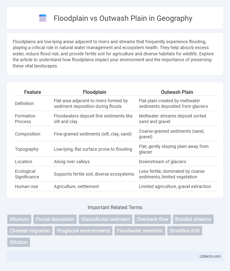
| Feature | Floodplain | Outwash Plain |
|---|---|---|
| Definition | Flat area adjacent to rivers formed by sediment deposition during floods | Flat plain created by meltwater sediments deposited from glaciers |
| Formation Process | Floodwaters deposit fine sediments like silt and clay | Meltwater streams deposit sorted sand and gravel |
| Composition | Fine-grained sediments (silt, clay, sand) | Coarse-grained sediments (sand, gravel) |
| Topography | Low-lying, flat surface prone to flooding | Flat, gently sloping plain away from glacier |
| Location | Along river valleys | Downstream of glaciers |
| Ecological Significance | Supports fertile soil, diverse ecosystems | Less fertile, dominated by coarse sediments, limited vegetation |
| Human Use | Agriculture, settlement | Limited agriculture, gravel extraction |
Introduction to Floodplains and Outwash Plains
Floodplains are flat areas adjacent to rivers formed by the periodic deposition of sediment during flooding, creating fertile soil ideal for agriculture. Outwash plains are expansive landforms composed of sorted sediments deposited by meltwater streams flowing from glaciers, characterized by stratified sand and gravel. Both features reflect distinct depositional processes critical to understanding landscape development and sediment distribution in fluvial and glacial environments.
Formation Processes of Floodplains
Floodplains form through the deposition of sediment during periodic river flooding, where water overflows its banks and spreads across the adjacent flat land, allowing fine particles like silt and clay to settle. This cyclic flooding deposits alluvium, gradually building fertile soil layers that support diverse ecosystems and agriculture. Unlike outwash plains formed by glacial meltwater distributing coarser materials, floodplains result from fluvial processes driven by river dynamics and seasonal hydrological changes.
How Outwash Plains Develop
Outwash plains develop through the deposition of sediments carried by meltwater streams flowing from glaciers, spreading out large amounts of sand, gravel, and finer particles across broad, flat areas. These plains are typically found beyond the terminal moraine of a glacier, where the retreating ice releases meltwater that sorts and layers the sediments. Unlike floodplains, which form from river flooding in valleys, outwash plains are primarily shaped by glacial meltwater processes and are characterized by well-sorted sediments and braided stream channels.
Key Geological Differences
Floodplains are flat areas adjacent to rivers formed by sediment deposits during periodic flooding, composed mainly of silt, sand, and clay, supporting fertile soils. Outwash plains develop beyond glacial termini, consisting of stratified sand and gravel deposited by meltwater streams, characterized by well-sorted sediments and braided drainage patterns. Key geological differences include formation processes--fluvial flooding for floodplains versus glacial meltwater deposition for outwash plains--and sediment texture variations influencing soil drainage and landscape morphology.
Soil Composition and Sediment Characteristics
Floodplains consist of fine-grained, nutrient-rich alluvial soils primarily composed of silts and clays deposited by recurring river floods, promoting fertile agricultural land. Outwash plains feature well-sorted, coarse-grained sediments such as sands and gravels transported and deposited by glacial meltwater, resulting in highly permeable soils with poor nutrient retention. The contrasting sediment characteristics influence drainage patterns and soil fertility between these depositional environments.
Hydrology and Water Flow Patterns
Floodplains form adjacent to rivers and are characterized by periodic flooding that deposits fine sediments, creating fertile soil and influencing groundwater recharge through slow infiltration. Outwash plains develop from glacial meltwater streams, featuring well-sorted sands and gravels with high permeability that facilitate rapid groundwater flow and efficient drainage. Hydrologically, floodplains exhibit intermittent surface water retention and lateral water movement, while outwash plains promote primarily vertical water percolation and extensive subsurface flow.
Ecological Significance and Biodiversity
Floodplains support diverse ecosystems due to nutrient-rich sediments deposited during regular flooding, fostering habitats for amphibians, fish, and various bird species. Outwash plains, formed by glacial meltwater deposits, feature well-drained soils and sparse vegetation but serve as critical habitats for specialized plant species and ground-nesting birds adapted to harsh, dynamic environments. Both landforms play essential roles in sustaining regional biodiversity and ecological resilience through their distinct hydrological and soil characteristics.
Human Impact and Land Use
Floodplains often support intensive agriculture due to their fertile soils and flat terrain, but human settlements on these lands face high flood risks, requiring extensive flood management infrastructure. Outwash plains, formed by glacial meltwater deposits, typically exhibit coarse sediments and poor natural drainage, limiting their agricultural potential and favoring uses such as grazing, quarrying, or urban development where soil engineering is applied. Urban expansion on both landforms increases impervious surfaces, altering natural hydrology and exacerbating flood hazards downstream.
Floodplain vs Outwash Plain: Environmental Risks
Floodplains are susceptible to frequent flooding, leading to soil erosion, nutrient loss, and water contamination, which can disrupt ecosystems and human settlements. Outwash plains, formed by glacial meltwater deposits, face risks such as sediment overload and rapid drainage changes, increasing the potential for flash floods and habitat alteration. Both landforms require careful management to mitigate environmental hazards associated with water flow and sediment dynamics.
Summary Table: Comparing Floodplain and Outwash Plain
Floodplains and outwash plains differ primarily in their formation and sediment characteristics; floodplains develop alongside rivers from periodic flooding and consist mostly of fine silts and clays, while outwash plains form from glacial meltwater deposits, dominated by stratified sands and gravels. Floodplains exhibit rich, fertile soils suitable for agriculture, experiencing frequent flooding, whereas outwash plains are generally well-drained with coarser sediments and less vegetation cover. Key distinctions include their depositional environment, sediment grain size, and typical land use, making these geomorphological features important for understanding landscape evolution and flood risk management.
Floodplain Infographic