Floodplains are flat areas adjacent to rivers and streams that frequently experience flooding, playing a crucial role in natural water management and ecosystem support. These zones absorb excess water during heavy rains, reducing flood risks downstream while providing fertile soil for agriculture and habitats for diverse wildlife. Explore the rest of this article to understand how managing your floodplain can protect communities and preserve environmental health.
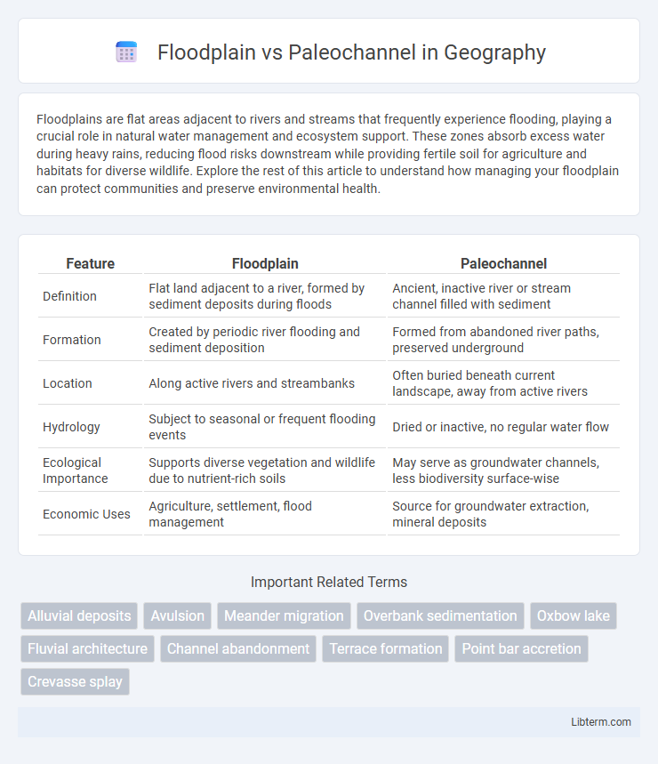
Table of Comparison
| Feature | Floodplain | Paleochannel |
|---|---|---|
| Definition | Flat land adjacent to a river, formed by sediment deposits during floods | Ancient, inactive river or stream channel filled with sediment |
| Formation | Created by periodic river flooding and sediment deposition | Formed from abandoned river paths, preserved underground |
| Location | Along active rivers and streambanks | Often buried beneath current landscape, away from active rivers |
| Hydrology | Subject to seasonal or frequent flooding events | Dried or inactive, no regular water flow |
| Ecological Importance | Supports diverse vegetation and wildlife due to nutrient-rich soils | May serve as groundwater channels, less biodiversity surface-wise |
| Economic Uses | Agriculture, settlement, flood management | Source for groundwater extraction, mineral deposits |
Understanding Floodplains: Definition and Characteristics
Floodplains are low-lying areas adjacent to rivers and streams, characterized by periodic flooding that deposits nutrient-rich sediments, fostering fertile soil and diverse ecosystems. These regions exhibit geomorphological features such as levees, natural levees, backswamps, and meander scars, which influence water flow and habitat distribution. Floodplains play a crucial role in hydrological processes, groundwater recharge, and flood mitigation, differentiating them from paleochannels, which are ancient, inactive river channels preserved in geological strata.
What Are Paleochannels? Key Features Explained
Paleochannels are ancient river or stream channels that have been filled or buried by sediment over time, often preserving evidence of past hydrological activity. Key features of paleochannels include distinct sedimentary deposits such as coarse-grained sands and gravels, well-defined meandering patterns, and geomorphological signatures detectable through remote sensing or subsurface investigations. These channels provide valuable insights into historical drainage systems, paleoclimate conditions, and can influence modern groundwater flow and resource exploration.
Geological Formation: Floodplain vs Paleochannel
Floodplains form through the deposition of alluvial sediments during periodic river overflows, creating fertile and flat landscapes adjacent to active river channels. Paleochannels are ancient, now inactive riverbeds filled with sediments that reveal past fluvial processes and shifts in river courses over geological time. Both features provide critical insights into sedimentary environments, hydrological dynamics, and landscape evolution in geological formations.
Hydrological Processes in Floodplains and Paleochannels
Floodplains act as natural reservoirs, absorbing excess water during floods and facilitating groundwater recharge through infiltration, while paleochannels represent ancient river channels that retain subsurface flow pathways influencing modern hydrological connectivity. Floodplain hydrology is characterized by periodic inundation and sediment deposition, which regulate nutrient cycling and water storage, whereas paleochannels influence current flow by directing subsurface water movement along relict channels with distinct permeability. Understanding these processes aids in flood risk management, groundwater resource assessment, and ecological restoration by highlighting the contrasting roles of active floodplains and inactive paleochannels in hydrological dynamics.
Sediment Deposits: Comparing Floodplains and Paleochannels
Floodplains accumulate fine-grained alluvial sediments through periodic flooding, creating fertile soils rich in silt, clay, and organic matter that support diverse ecosystems. Paleochannels contain coarser sediments like sand and gravel deposited by ancient river flows, preserving evidence of past hydrological conditions and channel migration. These differing sediment types influence soil permeability, nutrient availability, and groundwater recharge in their respective fluvial environments.
Ecological Importance of Floodplains and Paleochannels
Floodplains serve as critical ecological zones that support diverse habitats, promote nutrient cycling, and sustain wetland ecosystems by regulating water flow and storing floodwaters. Paleochannels, remnants of ancient river paths, preserve unique sedimentary environments that offer valuable insights into historical hydrology and provide refuge for specialized flora and fauna. Both floodplains and paleochannels contribute significantly to biodiversity conservation, groundwater recharge, and the maintenance of aquatic ecosystems.
Human Impact: Influence on Floodplains and Paleochannels
Human activities such as urbanization, agriculture, and dam construction significantly alter floodplains by disrupting natural water flow, sediment deposition, and nutrient cycling, leading to increased flood risks and habitat loss. Paleochannels, ancient river channels often buried or inactive, are affected by groundwater extraction and land development, which can change subsurface water paths and impact archaeological and geological research. Understanding these influences is crucial for sustainable land management and mitigating adverse environmental and societal effects.
Floodplain and Paleochannel Identification Techniques
Floodplain identification techniques primarily involve remote sensing methods such as satellite imagery analysis and LiDAR topographic mapping, which reveal characteristic flat, low-lying areas adjacent to rivers prone to flooding. Paleochannel identification relies on geophysical surveys like ground-penetrating radar and seismic reflection profiles to detect ancient river courses buried beneath sediments. Combining these techniques enhances the accuracy of distinguishing active floodplains from relict paleochannels, critical for flood risk assessment and groundwater resource management.
Land Use Planning: Floodplain vs Paleochannel Considerations
Floodplains are low-lying areas adjacent to rivers prone to flooding, requiring strict land use planning to minimize flood risks and preserve ecological functions. Paleochannels, ancient riverbeds now often buried, can influence subsurface hydrology and soil stability, necessitating careful assessment for construction and groundwater management. Effective land use planning incorporates floodplain zoning restrictions and paleochannel mapping to optimize development safety and environmental sustainability.
Floodplain vs Paleochannel: Key Differences and Similarities
Floodplains are flat areas adjacent to rivers formed by sediment deposition during floods, while paleochannels are ancient, inactive river channels preserved in the geological record. Both features indicate past river activity but differ in their current hydrological function, with floodplains actively shaping landscapes and supporting ecosystems, whereas paleochannels serve as indicators of historical fluvial processes. Floodplains generally exhibit fertile soils and dynamic water flow, contrasting with the often buried and fossilized nature of paleochannels used in hydrogeology and resource exploration.
Floodplain Infographic