Plate tectonics explains the movement of Earth's lithospheric plates and the resulting geological activity such as earthquakes, volcanic eruptions, and mountain building. Understanding these processes helps you grasp how continents drift and shape the planet's surface over millions of years. Explore the detailed mechanisms behind plate interactions and their impact in the rest of this article.
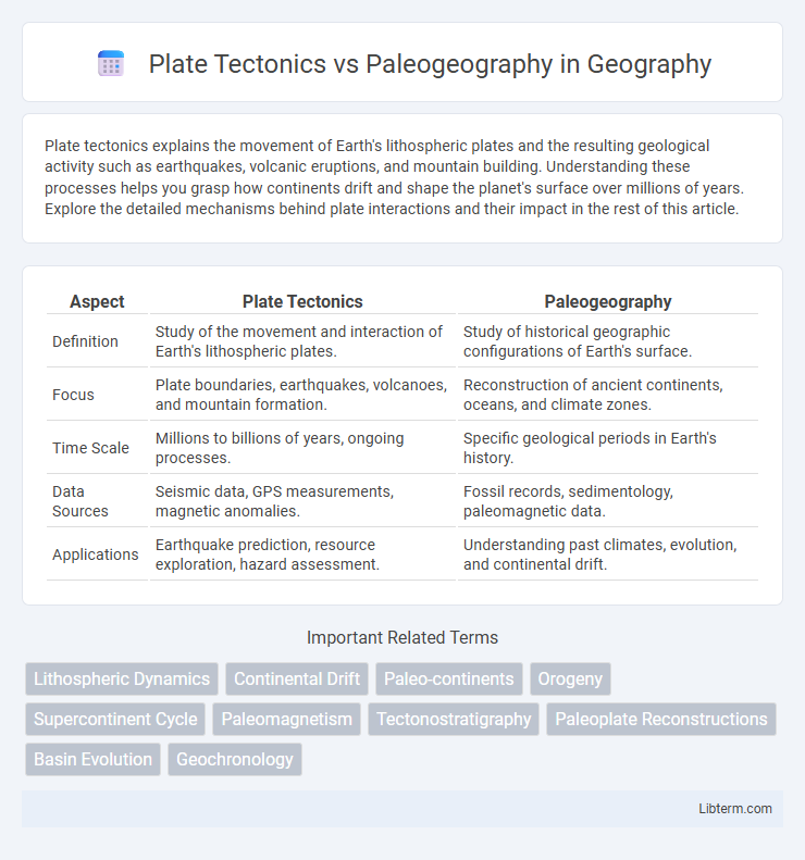
Table of Comparison
| Aspect | Plate Tectonics | Paleogeography |
|---|---|---|
| Definition | Study of the movement and interaction of Earth's lithospheric plates. | Study of historical geographic configurations of Earth's surface. |
| Focus | Plate boundaries, earthquakes, volcanoes, and mountain formation. | Reconstruction of ancient continents, oceans, and climate zones. |
| Time Scale | Millions to billions of years, ongoing processes. | Specific geological periods in Earth's history. |
| Data Sources | Seismic data, GPS measurements, magnetic anomalies. | Fossil records, sedimentology, paleomagnetic data. |
| Applications | Earthquake prediction, resource exploration, hazard assessment. | Understanding past climates, evolution, and continental drift. |
Introduction to Plate Tectonics and Paleogeography
Plate tectonics explains the movement of Earth's lithospheric plates, driving the formation of continents, mountains, and ocean basins. Paleogeography reconstructs past geographic landscapes and environmental conditions by analyzing fossil records, sediment deposits, and tectonic activity. Together, these fields provide insights into Earth's dynamic history and the shifting positions of landmasses over geological time.
Defining Plate Tectonics: The Science of Moving Plates
Plate tectonics is the scientific study of Earth's lithosphere divided into rigid plates that move over the asthenosphere, driving continental drift, earthquake activity, and volcanic eruptions. This theory explains the mechanisms behind plate boundaries, including divergent, convergent, and transform faults, and their role in shaping Earth's surface features. Understanding plate tectonics is essential for reconstructing paleogeographic maps that depict past continental positions and oceanic configurations through geological time.
Understanding Paleogeography: Mapping Ancient Earth
Mapping ancient Earth through paleogeography involves reconstructing historical landmasses, ocean basins, and climate zones by analyzing fossil distributions, sedimentary records, and tectonic plate movements. Plate tectonics provides the framework for these reconstructions by explaining the shifts and interactions of Earth's lithospheric plates over geological time. Integrating geological, paleontological, and geophysical data enables accurate modeling of Earth's past geography, crucial for understanding climate evolution and biodiversity patterns.
Key Concepts: Differences Between Plate Tectonics and Paleogeography
Plate tectonics explains the movement and interaction of Earth's lithospheric plates, driving processes like continental drift, earthquakes, and volcanic activity. Paleogeography reconstructs past physical landscapes, including landmass distribution, ocean basins, and climate zones, based on geological and fossil records. The key difference lies in plate tectonics focusing on dynamic, ongoing geophysical processes, while paleogeography emphasizes the historical spatial configuration of Earth's surface through geological time.
How Plate Tectonics Shapes Paleogeographic Reconstructions
Plate tectonics provides the foundational framework for paleogeographic reconstructions by explaining the historical movement of Earth's lithospheric plates, which shapes continental positions and ocean basin configurations over geological time. Paleogeographic maps integrate plate tectonic data such as plate boundaries, spreading rates, and subduction zones to visualize past landscapes, climate zones, and biogeographic distributions. The dynamic interactions at plate boundaries, including rifting, collision, and subduction, directly influence sedimentary basins, mountain formation, and ocean circulation patterns critical for accurate paleogeographic modeling.
Major Events Influenced by Plate Movements
Major events influenced by plate movements include the formation of mountain ranges such as the Himalayas due to the collision of the Indian and Eurasian plates. The breakup of the supercontinent Pangaea triggered significant shifts in ocean currents and climate patterns, shaping paleogeographic configurations. Volcanic activity and the creation of ocean basins, like the Mid-Atlantic Ridge, illustrate the dynamic processes driving both plate tectonics and paleogeographic evolution.
Tools and Methods Used in Plate Tectonics Studies
Plate tectonics studies primarily utilize GPS measurements, seismic tomography, and ocean floor mapping to analyze crustal movements and plate boundaries with high precision. Paleomagnetic data from rock samples and radiometric dating techniques provide temporal and directional information on past plate positions and motions. Advanced computational models integrate geological, geophysical, and geochemical datasets to simulate plate interactions and reconstruct tectonic histories.
Techniques for Paleogeographic Reconstruction
Techniques for paleogeographic reconstruction rely heavily on plate tectonics principles, incorporating data such as paleomagnetic records, fossil distribution, and sedimentary facies analysis to map ancient continental configurations and ocean basins. Geophysical methods, including seismic tomography and gravity anomalies, complement these techniques by revealing subsurface structures that inform tectonic history and past plate movements. Integrating GIS databases with stratigraphic and paleoenvironmental data enhances the precision of reconstructing Earth's paleogeography through geological time.
The Importance of Integrating Plate Tectonics and Paleogeography
Integrating plate tectonics and paleogeography is crucial for reconstructing Earth's historical landscapes and understanding continental drift's impact on climate and biodiversity. Plate tectonics provides the dynamic framework of moving lithospheric plates, while paleogeography maps past landforms and ocean distributions, allowing scientists to correlate tectonic events with paleoclimatic and paleoenvironmental changes. This integration enhances predictive models of Earth's geological evolution and helps decipher the spatial and temporal patterns of ancient ecosystems.
Future Directions in Earth Science Research
Future directions in Earth science research emphasize integrating high-resolution plate tectonics models with advanced paleogeographic reconstructions to enhance understanding of Earth's dynamic history. Innovations in geospatial data analysis and machine learning are expected to improve the accuracy of past continental configurations and tectonic plate movements. This integrated approach aims to refine predictions of future geological processes and their impacts on climate and biodiversity.
Plate Tectonics Infographic