Mesa formations are flat-topped hills with steep sides, often found in arid and semi-arid regions, shaped by erosion over time. Understanding the unique geological processes behind mesas can enhance your appreciation of natural landscapes and their ecological significance. Explore the rest of the article to discover fascinating facts and tips for visiting these striking landforms.
Table of Comparison
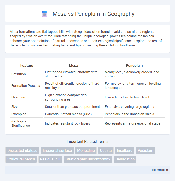
| Feature | Mesa | Peneplain |
|---|---|---|
| Definition | Flat-topped elevated landform with steep sides | Nearly level, extensively eroded land surface |
| Formation Process | Result of differential erosion of hard rock layers | Formed by long-term erosion leveling landscapes |
| Elevation | High elevation compared to surrounding area | Low relief, close to base level |
| Size | Smaller than plateaus but prominent | Extensive, covering large regions |
| Examples | Colorado Plateau mesas (USA) | Peneplain in the Canadian Shield |
| Geological Significance | Indicates resistant rock layers | Represents a mature erosional stage |
Introduction to Mesa and Peneplain
A mesa is a flat-topped hill with steep sides, commonly found in arid environments, formed by erosion-resistant rock layers that protect the underlying softer strata. In contrast, a peneplain is an extensive, nearly level land surface created by prolonged erosion, representing the final stage of landscape evolution before uplift. Both landforms illustrate the dynamic processes of weathering and erosion shaping Earth's surface over geological timescales.
Geological Definitions of Mesa and Peneplain
A mesa is a flat-topped, steep-sided landform commonly found in arid regions, formed by erosion-resistant rock layers that cap softer strata beneath, preventing rapid weathering. A peneplain is an extensive, nearly level land surface produced by prolonged erosion and denudation that reduces the terrain to a low-relief plain near sea level. While mesas represent youthful, differential erosion features, peneplains indicate the final stage of landscape evolution marked by minimal topographic relief.
Formation Processes: Mesa vs Peneplain
Mesas form primarily through differential erosion, where resistant rock layers cap the flat-topped hills, protecting underlying softer strata from weathering and erosion, resulting in steep, cliff-like edges. Peneplains develop over geological timescales via extensive weathering and erosion, wearing down elevated areas into nearly level surfaces close to base level with minimal relief. The key difference lies in mesas being isolated, elevated landforms preserved by harder rock, while peneplains represent vast, low-relief landscapes formed from prolonged denudation.
Key Morphological Features
A mesa is characterized by a flat-topped hill or mountain with steep, often vertical sides, formed due to differential erosion of resistant rock layers above softer substrates. A peneplain represents an extensive, nearly level land surface resulting from prolonged erosion and denudation over geological timescales, showing minimal relief and gentle slopes. Key morphological differences include the pronounced elevation and steep escarpments of mesas compared to the expansive, subdued topography of peneplains.
Global Distribution and Notable Examples
Mesas are flat-topped hills with steep sides, commonly found in arid regions like the southwestern United States, particularly the Colorado Plateau, and parts of Australia and East Africa. Peneplains are extensive, nearly level land surfaces representing the final stage of fluvial erosion, with notable examples including the African surface in Southern Africa and the Canadian Shield in North America. Both landforms illustrate diverse geological processes shaping Earth's surface across different climatic zones globally.
Erosion and Weathering: Influences on Landforms
Mesas form through differential erosion where resistant rock layers protect underlying softer strata, resulting in flat-topped hills with steep sides. Peneplains represent highly eroded landscapes characterized by extensive weathering and low relief, indicating prolonged erosion under stable tectonic conditions. The contrast in erosion rates between hard cap rocks and underlying materials shapes mesas, whereas uniform weathering and sediment removal contribute to the development of peneplains.
Ecological and Environmental Significance
Mesas, characterized by their flat-topped elevations and steep sides, create unique microhabitats that support diverse plant and animal species adapted to arid, exposed conditions, playing a crucial role in preserving regional biodiversity. Peneplains represent extensive, nearly level landforms formed through long-term erosion, providing stable soil environments that enhance groundwater recharge and support broad ecosystems with rich vegetation cover. Both landforms influence local climate regulation and watershed dynamics, contributing significantly to ecological resilience and environmental sustainability in their respective regions.
Mesa and Peneplain in Geological Timescales
Mesas and peneplains represent distinct landforms shaped over geological timescales, where mesas are isolated flat-topped hills with steep cliffs formed by differential erosion in arid environments, often preserving resistant rock layers from older sedimentary sequences. Peneplains are extensive, nearly level surfaces formed by prolonged erosion and denudation, indicating a mature stage of landscape evolution that can span hundreds of millions of years since the Precambrian era. The contrast between the relatively young, sharply defined mesas and the ancient, gently undulating peneplains reflects varying geological processes and timescales influencing Earth's surface morphology.
Human Impact and Land Use
Mesas, characterized by their steep sides and flat tops, often limit extensive human development due to their rugged terrain and soil constraints, resulting in specialized land use such as grazing or conservation areas. Peneplains, with their gently undulating surfaces, provide more favorable conditions for agriculture, urban expansion, and infrastructure development, promoting denser human settlements. Land use on peneplains typically involves intensive farming and residential projects, whereas mesas frequently preserve natural habitats due to less accessibility and lower agricultural potential.
Mesa vs Peneplain: Comparative Summary
Mesa and peneplain differ significantly in geomorphology and formation processes. A mesa is a flat-topped hill with steep sides formed by resistant rock layers, typically found in arid environments, while a peneplain is an extensive, nearly level land surface produced by prolonged erosion and denudation. The key distinction lies in their scale and development stage: mesas represent localized, relatively young erosional remnants, whereas peneplains indicate mature landscapes nearing base level equilibrium.
Mesa Infographic