Field observation provides direct insight into real-world environments, allowing researchers to collect authentic data on behaviors and interactions. This method is crucial for understanding contexts that laboratory settings cannot replicate, enhancing the accuracy of your findings. Explore the article further to discover effective techniques and best practices for conducting impactful field observations.
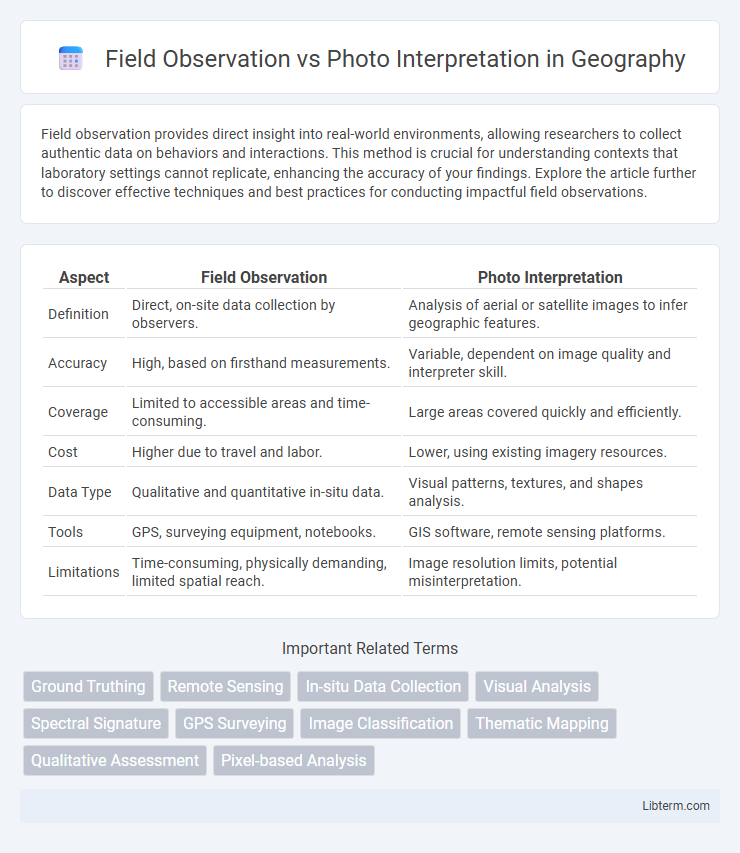
Table of Comparison
| Aspect | Field Observation | Photo Interpretation |
|---|---|---|
| Definition | Direct, on-site data collection by observers. | Analysis of aerial or satellite images to infer geographic features. |
| Accuracy | High, based on firsthand measurements. | Variable, dependent on image quality and interpreter skill. |
| Coverage | Limited to accessible areas and time-consuming. | Large areas covered quickly and efficiently. |
| Cost | Higher due to travel and labor. | Lower, using existing imagery resources. |
| Data Type | Qualitative and quantitative in-situ data. | Visual patterns, textures, and shapes analysis. |
| Tools | GPS, surveying equipment, notebooks. | GIS software, remote sensing platforms. |
| Limitations | Time-consuming, physically demanding, limited spatial reach. | Image resolution limits, potential misinterpretation. |
Introduction to Field Observation and Photo Interpretation
Field observation involves direct, on-site data collection to capture accurate environmental and physical details, essential for validating remote sensing data. Photo interpretation analyzes aerial or satellite images to identify landscape features, providing a broad overview without physical presence. Combining both methods enhances accuracy by integrating ground truth data with spatial imagery analysis.
Defining Field Observation
Field observation involves the direct and systematic collection of data by physically visiting a site to observe and record environmental, social, or geological conditions. This method provides real-time, detailed insights that capture nuances and dynamic changes which remote techniques may overlook. Accurate field observation is essential for validating and calibrating data obtained through photo interpretation and other remote sensing methods.
Understanding Photo Interpretation
Photo interpretation involves analyzing aerial or satellite images to extract information about the Earth's surface, allowing for the identification of land use, vegetation, and geological features without physical presence. Understanding photo interpretation requires recognizing patterns, textures, shadows, and spectral signatures that differentiate objects and materials in the imagery. This method complements field observation by providing a broad spatial context and enabling the monitoring of large or inaccessible areas efficiently.
Key Differences Between Field Observation and Photo Interpretation
Field observation involves direct, on-site data collection, offering real-time, detailed insights into environmental and physical conditions, whereas photo interpretation analyzes aerial or satellite images to infer characteristics from a distance. Field observation provides tactile, ground-truth evidence crucial for validating remote sensing data, while photo interpretation covers larger areas quickly, enabling broad spatial analysis. Key differences include the immediacy of data acquisition, scale of analysis, and dependence on subjectivity in interpreting visual cues versus objective measurement.
Advantages of Field Observation
Field observation provides direct, real-time data collection, allowing researchers to identify subtle environmental changes and verify ground truth with high accuracy. This method enhances the understanding of spatial relationships and ecological context that might be missed in photo interpretation due to image resolution limits or seasonal variations. Field observation also enables the documentation of dynamic processes and immediate human activity impacts, which are critical for precise resource management and environmental assessments.
Benefits of Photo Interpretation
Photo interpretation enhances spatial analysis by providing detailed visual information that is often inaccessible through field observation alone. It enables rapid assessment over large and remote areas, significantly reducing time and resource costs while improving data accuracy. Advanced technologies like multispectral and hyperspectral imaging further increase the precision and scope of environmental monitoring, land use planning, and disaster management.
Limitations of Field Observation
Field observation is limited by accessibility challenges, time constraints, and potential observer bias, which can hinder comprehensive data collection over large or remote areas. Weather conditions and terrain obstacles may restrict visibility and data accuracy, reducing the reliability of field observations for extensive spatial analysis. Unlike photo interpretation, field observation often lacks the ability to rapidly cover vast regions, making it less efficient for monitoring environmental changes or land-use patterns over time.
Challenges in Photo Interpretation
Photo interpretation faces challenges such as misidentification of features due to shadows, seasonal changes, and resolution limitations in aerial or satellite imagery. Variability in image quality and the complexity of terrain can lead to errors in classification and analysis. Interpretation often requires extensive experience and ground-truthing to validate findings and reduce uncertainty.
Integrating Field Observation and Photo Interpretation
Integrating field observation and photo interpretation enhances accuracy in environmental assessments by combining on-ground data with aerial imagery analysis. Field observations provide detailed, context-specific information that validates and complements photo interpretation's broader spatial coverage, enabling precise mapping and monitoring of land use and vegetation changes. This synergy optimizes resource management by leveraging real-time insights and remote sensing data for comprehensive landscape evaluation.
Choosing the Right Approach for Your Research
Field observation provides direct, real-time data collection essential for detailed ecological and sociological studies, ensuring accuracy in behavior and environment analysis. Photo interpretation offers rapid, cost-effective analysis of large geographic areas through aerial or satellite imagery, ideal for land use, vegetation mapping, and environmental monitoring. Selecting between these methods depends on research objectives, spatial scale, budget constraints, and the required level of detail.
Field Observation Infographic