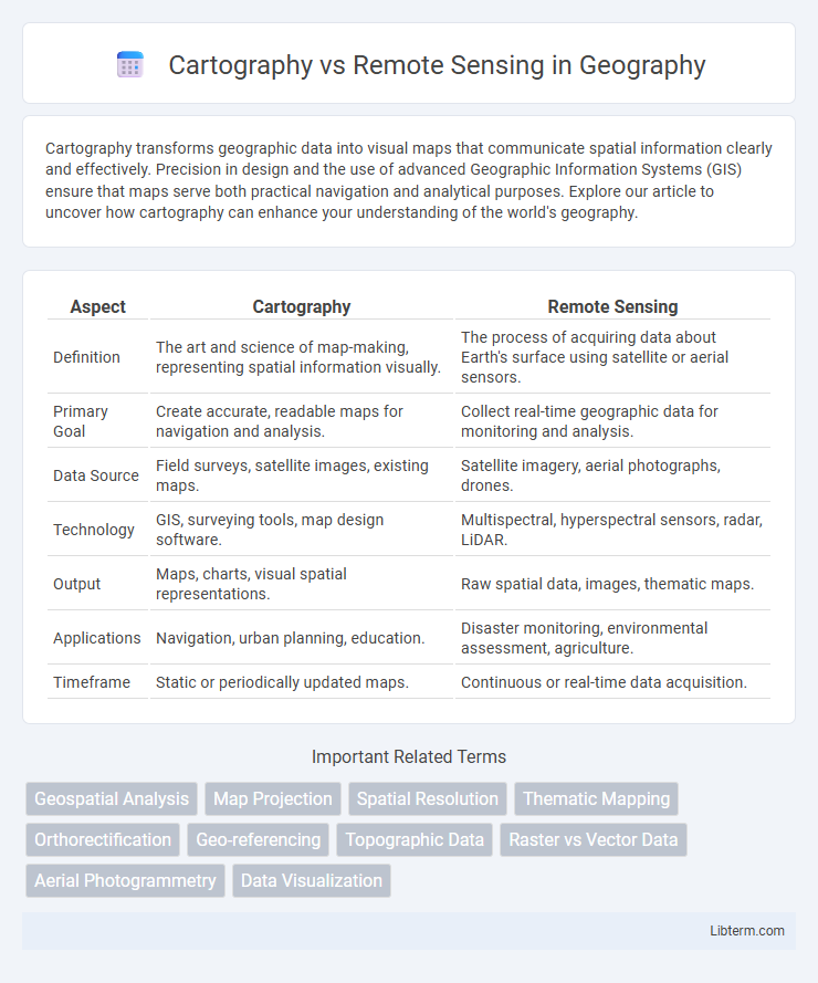
Cartography transforms geographic data into visual maps that communicate spatial information clearly and effectively. Precision in design and the use of advanced Geographic Information Systems (GIS) ensure that maps serve both practical navigation and analytical purposes. Explore our article to uncover how cartography can enhance your understanding of the world's geography.
Table of Comparison
| Aspect | Cartography | Remote Sensing |
|---|---|---|
| Definition | The art and science of map-making, representing spatial information visually. | The process of acquiring data about Earth's surface using satellite or aerial sensors. |
| Primary Goal | Create accurate, readable maps for navigation and analysis. | Collect real-time geographic data for monitoring and analysis. |
| Data Source | Field surveys, satellite images, existing maps. | Satellite imagery, aerial photographs, drones. |
| Technology | GIS, surveying tools, map design software. | Multispectral, hyperspectral sensors, radar, LiDAR. |
| Output | Maps, charts, visual spatial representations. | Raw spatial data, images, thematic maps. |
| Applications | Navigation, urban planning, education. | Disaster monitoring, environmental assessment, agriculture. |
| Timeframe | Static or periodically updated maps. | Continuous or real-time data acquisition. |
Introduction to Cartography and Remote Sensing
Cartography involves the science and art of creating maps that visually represent spatial information, emphasizing accurate geographic data interpretation and design. Remote sensing employs satellite or aerial sensor technologies to collect data about the Earth's surface without direct contact, providing dynamic and large-scale environmental observations. Both fields integrate geospatial technologies but differ in data acquisition methods and applications, with cartography focusing on map creation and remote sensing on data collection and analysis.
Defining Cartography: The Art and Science of Mapmaking
Cartography merges artistic design and scientific principles to create accurate and visually engaging maps. It involves the systematic representation of spatial data, emphasizing scale, projection, and symbolization to convey geographic information effectively. Advances in technology have enhanced cartographic precision, integrating Geographic Information Systems (GIS) for dynamic and interactive map production.
Understanding Remote Sensing: Principles and Applications
Remote sensing involves acquiring information about Earth's surface without direct contact, using sensors on satellites or aircraft to detect electromagnetic radiation reflected or emitted from objects. Key principles include sensor types (passive and active), spectral imaging, and data processing techniques that transform raw data into meaningful spatial information. Applications span environmental monitoring, urban planning, agriculture, and disaster management, providing critical insights for mapping and decision-making beyond traditional cartography methods.
Key Technologies in Cartography and Remote Sensing
Cartography leverages Geographic Information Systems (GIS), Global Positioning System (GPS), and computer-aided design (CAD) software to create detailed, accurate maps through spatial data visualization and analysis. Remote sensing employs satellite sensors, LiDAR (Light Detection and Ranging), hyperspectral imaging, and radar technology to capture high-resolution images and environmental data from a distance. Both fields integrate advanced geospatial technologies, but cartography focuses on data representation, while remote sensing emphasizes data acquisition and interpretation.
Data Sources: Ground Observations vs. Satellite Imagery
Ground observations in cartography provide highly accurate, localized data collected through field surveys and GPS measurements, essential for detailed map creation and verification. Satellite imagery in remote sensing offers extensive, real-time coverage across large geographic areas, enabling the analysis of environmental changes, land use, and natural resource management. Combining both data sources enhances spatial accuracy and temporal monitoring, leveraging the strengths of precise ground truthing and broad-scale observation.
Accuracy and Precision in Cartography vs. Remote Sensing
Cartography emphasizes accuracy in map representation through precise spatial measurements and manual refinements, ensuring detailed and reliable visualizations. Remote sensing achieves high precision by capturing extensive geospatial data using satellite or aerial sensors, allowing for consistent and repeatable observations across broad areas. The integration of remote sensing data enhances cartographic accuracy by providing up-to-date and comprehensive information while maintaining spatial detail.
Major Applications in Mapping and Spatial Analysis
Cartography excels in creating detailed, accurate maps through data visualization and spatial representation, supporting urban planning, navigation, and thematic map production. Remote sensing provides real-time, multispectral data capture from satellites and aerial sensors, enabling applications in environmental monitoring, land use classification, and disaster management. Combining cartography with remote sensing enhances spatial analysis by integrating precise mapping with dynamic data acquisition for comprehensive geographic information systems (GIS).
Advantages and Limitations of Cartography
Cartography excels in visualizing spatial information through detailed maps, allowing for intuitive interpretation of geographic data and facilitating navigation and planning. Its key advantages include the ability to represent complex spatial relationships clearly and provide a tangible, user-friendly interface for various applications such as urban development, environmental management, and disaster response. Limitations of cartography arise from its dependence on static data, potential for outdated information, and challenges in capturing real-time environmental changes compared to dynamic remote sensing techniques.
Strengths and Challenges of Remote Sensing
Remote sensing excels in capturing large-scale, real-time data across diverse terrains, enabling precise environmental monitoring and disaster management without ground contact. Its challenges include dependency on weather conditions, sensor calibration complexities, and high costs associated with data acquisition and processing. Despite these hurdles, remote sensing remains crucial for timely, accurate spatial analysis when integrated with traditional cartographic methods.
Future Trends: Integrating Cartography and Remote Sensing
Emerging trends in cartography emphasize the integration of high-resolution remote sensing data to create dynamic, interactive maps with real-time updates and enhanced spatial accuracy. Advances in machine learning and AI enable the automated interpretation of remote sensing imagery, facilitating the seamless fusion of multispectral, LiDAR, and SAR datasets for comprehensive geospatial analysis. The future of geospatial technology prioritizes augmented reality and cloud-based platforms, allowing users to visualize and manipulate integrated cartographic and remote sensing information for smarter decision-making across diverse sectors.
Cartography Infographic

 libterm.com