Topography shapes the natural and built environment by detailing the elevations, slopes, and contours of the land surface. Understanding topography is essential for fields like urban planning, architecture, and environmental management to make informed decisions about construction, drainage, and land use. Explore the rest of this article to discover how topography influences diverse aspects of your surroundings.
Table of Comparison
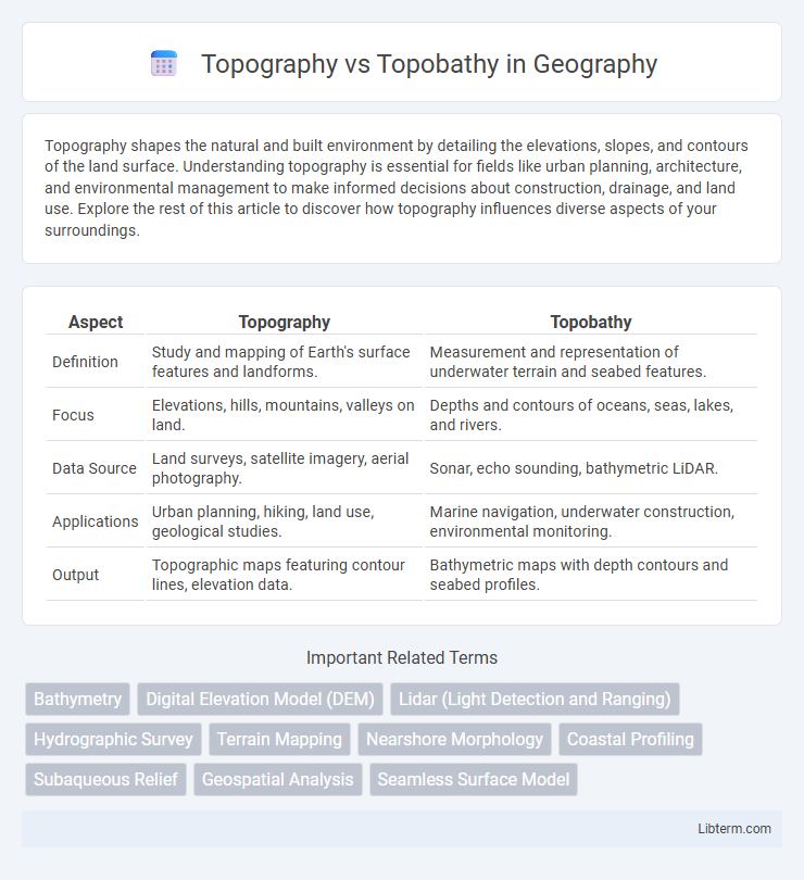
| Aspect | Topography | Topobathy |
|---|---|---|
| Definition | Study and mapping of Earth's surface features and landforms. | Measurement and representation of underwater terrain and seabed features. |
| Focus | Elevations, hills, mountains, valleys on land. | Depths and contours of oceans, seas, lakes, and rivers. |
| Data Source | Land surveys, satellite imagery, aerial photography. | Sonar, echo sounding, bathymetric LiDAR. |
| Applications | Urban planning, hiking, land use, geological studies. | Marine navigation, underwater construction, environmental monitoring. |
| Output | Topographic maps featuring contour lines, elevation data. | Bathymetric maps with depth contours and seabed profiles. |
Introduction to Topography and Topobathy
Topography refers to the detailed mapping and description of the Earth's surface features, including mountains, valleys, and plains, emphasizing elevation and landforms above sea level. Topobathy combines topography with bathymetry, integrating terrestrial and underwater terrain data to create comprehensive models of coastal and underwater landscapes. Understanding topography and topobathy is crucial for environmental studies, urban planning, and marine navigation by providing precise elevation and depth information.
Defining Topography: Scope and Features
Topography refers to the detailed mapping and description of the Earth's surface features, including mountains, valleys, plains, and man-made structures. It focuses on the three-dimensional arrangement of terrain elements above sea level, emphasizing elevation, slope, and landform shapes. Unlike topobathy, which incorporates underwater terrain, topography strictly covers terrestrial landscapes and their physical characteristics.
Understanding Topobathy: What Sets It Apart
Topobathy refers to the measurement and mapping of underwater terrain, distinguishing it from traditional topography, which focuses on land elevations. Understanding topobathy involves analyzing data collected through sonar, LiDAR, or satellite technologies to create detailed bathymetric maps of seabed features. This distinction highlights its critical role in marine navigation, environmental monitoring, and coastal management.
Key Differences Between Topography and Topobathy
Topography refers to the study and mapping of the Earth's surface features, including elevation, terrain shapes, and landforms above sea level, while topobathy combines topographic data with bathymetric measurements to represent both land elevations and underwater depths. The primary difference lies in the scope: topography focuses exclusively on terrestrial landscapes, whereas topobathy integrates land topography with underwater topography, essential for coastal and marine studies. Data sources for topography typically include aerial surveys and LiDAR, while topobathy relies on sonar and satellite altimetry to capture seafloor elevations alongside terrestrial elevations.
Tools and Technologies Used in Topography
Topography involves detailed mapping of the Earth's surface using tools such as total stations, GPS receivers, and LiDAR scanners, which capture precise elevation and contour data. Advanced software like GIS and CAD systems process this spatial information for accurate terrain modeling and analysis. Unlike topography, topobathy integrates bathymetric technologies, including sonar and echo sounders, to map underwater landscape features.
Methods and Equipment in Topobathymetric Surveys
Topobathymetric surveys combine topographic and bathymetric data collection using integrated methods such as LiDAR for terrestrial elevation and sonar systems like multibeam echosounders for underwater mapping. Advanced GPS and inertial measurement units ensure precise positioning and motion compensation during data acquisition. Specialized equipment platforms include UAVs equipped with LiDAR sensors for terrain and small vessels equipped with echo sounders for submerged features, enhancing accuracy and efficiency in coastal and inland waterway studies.
Applications of Topographic Mapping
Topographic mapping provides detailed representations of land surface features, essential for urban planning, environmental management, and infrastructure development. These maps capture elevation, terrain variation, and natural landmarks, enabling accurate site assessments and disaster risk analysis. Unlike topobathy, which maps underwater terrains, topographic mapping focuses on terrestrial landscapes critical for land navigation and construction projects.
Uses of Topobathymetric Data in Environmental Studies
Topobathymetric data integrates terrestrial elevation and underwater depth measurements, providing comprehensive insights crucial for environmental studies. This data supports coastal erosion analysis, habitat mapping, and flood risk assessment by capturing the interface between land and water. Utilizing topobathymetric models enhances precision in ecosystem monitoring and informs sustainable resource management in dynamic coastal environments.
Challenges in Topography vs Topobathy Mapping
Topography mapping primarily deals with representing land surface features, while topobathy mapping involves combining terrestrial topography with underwater bathymetric data, posing challenges in integrating diverse datasets with differing scales and resolutions. Accurate alignment between aerial and sonar-based measurements requires advanced geospatial processing techniques to mitigate discrepancies caused by variable water clarity, sediment types, and depth variations. Data fusion complexity and the need for sophisticated correction algorithms increase costs and time, impacting the precision of coastal and riverine mapping essential for environmental monitoring and infrastructure development.
Future Trends in Topography and Topobathy Analysis
Advancements in remote sensing technologies and AI-driven data processing are revolutionizing future trends in topography and topobathy analysis, enabling ultra-high-resolution mapping of terrestrial and underwater surfaces. Integration of UAV-based photogrammetry and LiDAR with autonomous underwater vehicles (AUVs) enhances real-time data acquisition, supporting dynamic environmental monitoring and coastal management. Machine learning algorithms optimize terrain classification and predictive modeling, essential for disaster risk assessment and climate change adaptation strategies.
Topography Infographic