Remote sensing uses satellite or aerial sensor technologies to collect data about the Earth's surface without direct contact, enabling detailed analysis of environmental, agricultural, and urban areas. This technology provides critical insights for monitoring climate change, natural disasters, and land-use patterns. Discover how remote sensing can enhance your understanding of our planet by exploring the rest of this article.
Table of Comparison
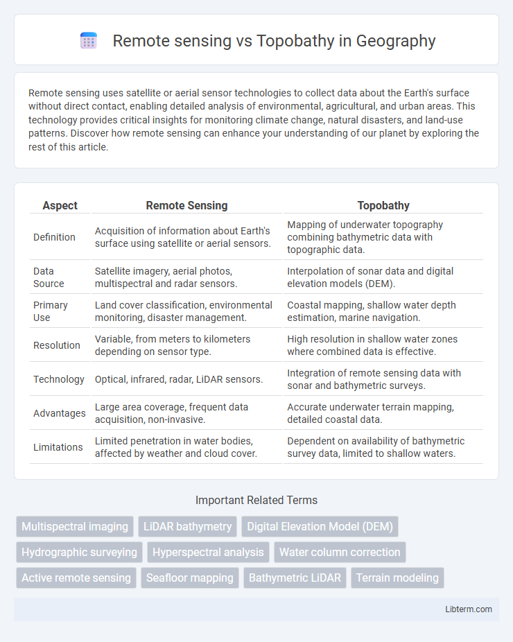
| Aspect | Remote Sensing | Topobathy |
|---|---|---|
| Definition | Acquisition of information about Earth's surface using satellite or aerial sensors. | Mapping of underwater topography combining bathymetric data with topographic data. |
| Data Source | Satellite imagery, aerial photos, multispectral and radar sensors. | Interpolation of sonar data and digital elevation models (DEM). |
| Primary Use | Land cover classification, environmental monitoring, disaster management. | Coastal mapping, shallow water depth estimation, marine navigation. |
| Resolution | Variable, from meters to kilometers depending on sensor type. | High resolution in shallow water zones where combined data is effective. |
| Technology | Optical, infrared, radar, LiDAR sensors. | Integration of remote sensing data with sonar and bathymetric surveys. |
| Advantages | Large area coverage, frequent data acquisition, non-invasive. | Accurate underwater terrain mapping, detailed coastal data. |
| Limitations | Limited penetration in water bodies, affected by weather and cloud cover. | Dependent on availability of bathymetric survey data, limited to shallow waters. |
Introduction to Remote Sensing and Topobathy
Remote sensing utilizes satellite or aerial sensor technologies to collect data about the Earth's surface, enabling detailed analysis of land cover, vegetation, and environmental changes. Topobathy combines topographic and bathymetric data to create comprehensive 3D models of coastal zones, integrating land elevation with underwater terrain. Both techniques enhance geographic information systems (GIS) by providing critical spatial data for environmental monitoring, coastal management, and disaster response.
Core Principles of Remote Sensing
Remote sensing relies on the detection and measurement of electromagnetic radiation reflected or emitted from surfaces to capture data about the Earth's features, including land, water, and vegetation. Topobathy integrates bathymetric and topographic data to map underwater and terrain elevations, often derived through remote sensing methods like LiDAR and satellite imagery. Core principles of remote sensing encompass sensor-target interactions, energy source characteristics, and signal reception, which enable accurate surface characterization and environmental monitoring.
Fundamentals of Topobathymetric Mapping
Topobathymetric mapping integrates remote sensing technologies with bathymetric data to create detailed representations of coastal and underwater terrain. Utilizing LiDAR (Light Detection and Ranging) and high-resolution multispectral imagery, this approach captures both topographic and bathymetric features essential for flood modeling, habitat mapping, and navigation safety. The fundamental principle involves combining airborne or satellite remote sensing data with sonar or echo sounding measurements to accurately model water bodies alongside terrestrial landscapes.
Technological Tools Used in Remote Sensing
Remote sensing utilizes advanced technological tools such as satellites, multispectral and hyperspectral sensors, LiDAR, and drones equipped with high-resolution cameras to capture data from distant objects or surfaces. These tools enable the collection of extensive spatial and spectral information without physical contact, allowing for detailed analysis of land, vegetation, water bodies, and atmospheric conditions. In contrast, topobathy primarily relies on bathymetric sonar systems and GPS technology to map underwater topography, focusing on depth measurements rather than the multispectral data commonly obtained through remote sensing instruments.
Equipment and Techniques in Topobathy
Topobathy utilizes specialized equipment such as LiDAR sensors and multibeam echo sounders to capture detailed elevation and bathymetric data in coastal and riverine environments. Techniques in topobathy involve integrating airborne LiDAR bathymetry (ALB) with digital elevation models (DEMs) to accurately measure underwater topography and shoreline changes. Advanced data processing algorithms enhance the precision of topobathymetric maps by combining remote sensing inputs with hydrodynamic modeling for coastal management applications.
Key Differences: Remote Sensing vs Topobathy
Remote sensing involves collecting data from satellites or aircraft to analyze land, water, and atmospheric conditions, providing broad-scale environmental monitoring. Topobathy, a specialized form of remote sensing, integrates topographic and bathymetric data to map submerged and terrestrial landscapes, crucial for coastal and underwater studies. The key difference lies in topobathy's focus on nearshore and underwater terrain mapping, whereas general remote sensing covers diverse environmental parameters over larger areas.
Applications of Remote Sensing in Environmental Studies
Remote sensing technology plays a crucial role in environmental studies by enabling large-scale monitoring of land use, vegetation health, and water quality through satellite and aerial imagery. Unlike topobathy, which integrates topographic and bathymetric data primarily for coastal mapping and underwater terrain analysis, remote sensing provides diverse environmental applications such as deforestation tracking, climate change impact assessment, and disaster management. High-resolution multispectral and hyperspectral sensors detect changes in ecosystems and pollution levels, supporting effective conservation strategies and sustainable resource management.
Uses of Topobathy in Water Body Analysis
Topobathy combines topographic and bathymetric data to provide detailed elevation and underwater terrain information for water bodies, enhancing flood risk assessment and coastal management. It enables accurate mapping of shallow water depths, critical for navigation safety and habitat monitoring in rivers, lakes, and estuaries. Remote sensing techniques, such as LiDAR and satellite imagery, facilitate the collection of topobathymetric data, improving the precision of hydrological modeling and sediment transport analysis.
Challenges and Limitations of Both Methods
Remote sensing faces challenges such as cloud cover interference, limited spatial resolution, and difficulty penetrating water surfaces for accurate underwater mapping. Topobathy methods encounter limitations including high costs, labor-intensive data collection, and restricted coverage in turbid or deep waters. Both techniques require calibration and integration to overcome individual inaccuracies and improve overall bathymetric mapping precision.
Future Trends in Remote Sensing and Topobathy
Future trends in remote sensing and topobathy emphasize the integration of high-resolution multispectral and hyperspectral imaging with advanced machine learning algorithms to enhance data accuracy and depth mapping. The development of real-time remote sensing platforms using UAVs and satellite constellations promises more frequent and detailed topobathymetric surveys, supporting coastal monitoring and environmental management. Innovations in AI-driven data fusion are enabling the synthesis of diverse sensor inputs for comprehensive terrain and underwater landscape modeling.
Remote sensing Infographic