A drumlin is an elongated hill formed by glacial ice acting over sediment or till, typically shaped like an inverted spoon or a teardrop. These landforms provide valuable insights into past glacial movement and sediment deposition patterns. Explore the rest of the article to understand how drumlins reveal clues about Earth's glacial history and landscape evolution.
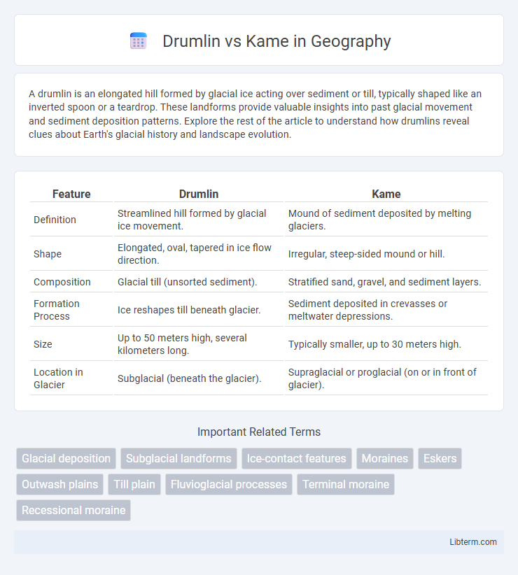
Table of Comparison
| Feature | Drumlin | Kame |
|---|---|---|
| Definition | Streamlined hill formed by glacial ice movement. | Mound of sediment deposited by melting glaciers. |
| Shape | Elongated, oval, tapered in ice flow direction. | Irregular, steep-sided mound or hill. |
| Composition | Glacial till (unsorted sediment). | Stratified sand, gravel, and sediment layers. |
| Formation Process | Ice reshapes till beneath glacier. | Sediment deposited in crevasses or meltwater depressions. |
| Size | Up to 50 meters high, several kilometers long. | Typically smaller, up to 30 meters high. |
| Location in Glacier | Subglacial (beneath the glacier). | Supraglacial or proglacial (on or in front of glacier). |
Introduction to Drumlins and Kames
Drumlins are streamlined, elongated hills formed by glacial ice, composed mainly of till, and shaped in the direction of ice movement. Kames are irregularly shaped mounds or hills made up of sand, gravel, and till deposited by melting glaciers in depressions or openings. Both landforms are key indicators of past glacial activity, with drumlins reflecting ice flow dynamics and kames representing sediment deposition patterns.
Defining Drumlins: Characteristics and Formation
Drumlins are streamlined, elongated hills composed primarily of glacial till, formed beneath moving ice sheets during the last Ice Age. These teardrop-shaped landforms typically measure 1 to 2 kilometers in length and exhibit a steep stoss side facing the direction of ice advance, with a tapered lee side indicating flow direction. Their formation involves the reshaping of sediment by subglacial deformation processes, distinguishing drumlins from kames, which are irregularly shaped mounds of stratified sand and gravel deposited in ice-marginal environments.
Understanding Kames: Features and Origins
Kames are irregularly shaped mounds of sand, gravel, and sediment formed by glacial meltwater depositing materials in crevasses or depressions. Unlike drumlins, which have streamlined, elongated shapes formed beneath moving ice, kames exhibit a more chaotic structure resulting from melting glaciers' sediment drops. Their formation provides key insights into glacial dynamics, sediment transport, and meltwater activity during the retreat of ice sheets.
Geological Processes Behind Drumlins
Drumlins form through the reshaping of glacial till beneath moving ice sheets, where subglacial deformation and sediment deposition create streamlined, elongated hills aligned with ice flow. In contrast, kames develop from meltwater sediment deposited in depressions or crevasses on glacial surfaces, resulting in irregularly shaped mounds composed of sorted sand and gravel. Understanding these distinct geological processes clarifies differences in morphology and sediment composition between drumlins and kames.
Formation of Kames: Glacial Deposition Explained
Kames are irregularly shaped mounds of sand and gravel formed by glacial deposition during the melting phase of glaciers, as sediments accumulate in crevasses or meltwater channels. Unlike drumlins, which are streamlined hills shaped by glacial ice movement, kames result from the stratified sediment left behind when meltwater deposits gravel and sand. The distinct stratification and random appearance of kames reflect their formation through water-borne sediments rather than direct ice sculpting.
Key Differences Between Drumlins and Kames
Drumlins are streamlined, elongated hills formed by glacial ice reshaping underlying till, typically oriented parallel to ice movement, whereas kames are irregularly shaped mounds composed of stratified sand and gravel deposited by meltwater. Drumlins consist primarily of compacted glacial till, indicating subglacial formation, while kames represent sediment accumulation in depressions or ice crevasses. The distinct morphologies and sediment compositions of drumlins and kames reflect different depositional processes within glacial environments.
Visual Identification: Drumlins vs Kames in the Landscape
Drumlins appear as smooth, elongated hills with a streamlined shape oriented in the direction of ice flow, typically featuring a steep stoss side and a gentle lee side. Kames are irregularly shaped mounds or hills composed of sand and gravel, often with a more chaotic and uneven surface due to sediment deposition from melting glaciers. Visual identification relies on recognizing the drumlin's uniform, teardrop-like form compared to the kame's irregular, hummocky appearance in glacial landscapes.
Ecological and Geographical Significance
Drumlins and kames are glacial landforms with distinct ecological and geographical significance, where drumlins form streamlined hills of glacial till shaped by ice movement, impacting drainage patterns and creating habitats for diverse plant species. Kames, composed of sand and gravel deposited by melting glaciers, contribute to varied topography that supports niche ecosystems and influences groundwater recharge. Both formations play crucial roles in shaping post-glacial landscapes and fostering regional biodiversity.
Famous Drumlin and Kame Sites Worldwide
Famous drumlin sites include the Boston Harbor Islands in the United States and the Oulu region in Finland, where elongated hills formed by glacial ice reveal classic streamlined shapes. Notable kame deposits are found in the Niagara Escarpment of Canada and Scotland's Isle of Skye, characterized by irregular, mounded gravel and sand formations left behind by retreating glaciers. These globally recognized landforms serve as key evidence of past glacial dynamics and are critical for studying ice age geomorphology.
Conclusion: Comparing Drumlins and Kames
Drumlins are streamlined, elongated hills formed by glacial ice reshaping underlying sediment, typically composed of compacted till, whereas kames are irregularly shaped mounds of stratified sand and gravel deposited by meltwater streams. Drumlins indicate ice flow direction through their tapered shape, contrasting with kames that reflect sediment accumulation in ice crevasses or depressions. Understanding these geomorphological differences aids in reconstructing past glacial dynamics and sedimentary environments.
Drumlin Infographic