Floodplains are low-lying areas adjacent to rivers and streams that periodically experience flooding, playing a crucial role in natural water management and ecosystem health. Understanding floodplain dynamics helps you better prepare for potential flood risks while preserving wildlife habitats and water quality. Explore the rest of this article to learn how floodplains impact communities and the environment.
Table of Comparison
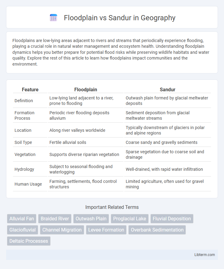
| Feature | Floodplain | Sandur |
|---|---|---|
| Definition | Low-lying land adjacent to a river, prone to flooding | Outwash plain formed by glacial meltwater deposits |
| Formation Process | Periodic river flooding deposits alluvium | Sediment deposition from glacial meltwater streams |
| Location | Along river valleys worldwide | Typically downstream of glaciers in polar and alpine regions |
| Soil Type | Fertile alluvial soils | Coarse sandy and gravelly sediments |
| Vegetation | Supports diverse riparian vegetation | Sparse vegetation due to coarse soil and drainage |
| Hydrology | Subject to seasonal flooding and waterlogging | Well-drained, with rapid water infiltration |
| Human Usage | Farming, settlements, flood control structures | Limited agriculture, often used for gravel mining |
Introduction to Floodplain and Sandur
A floodplain is a flat or nearly flat land area adjacent to a river or stream that experiences periodic flooding, playing a crucial role in sediment deposition and nutrient distribution. In contrast, a sandur is a glacial outwash plain formed by meltwater streams depositing sands and gravels beyond a glacier's terminus, characterized by braided channels and stratified sediments. Both landforms influence hydrology and sediment dynamics but differ significantly in origin and depositional processes.
Formation Processes of Floodplains
Floodplains form through the regular overflow of rivers depositing fine sediments along their banks, creating fertile, flat areas that expand during seasonal flooding. In contrast, sandurs are formed by glacial meltwater streams depositing coarse sediments like sand and gravel, creating broad outwash plains beyond glacier termini. Floodplains result primarily from fluvial processes involving sediment deposition during overbank flooding, whereas sandurs are shaped by glaciofluvial processes linked to glacier meltwater dynamics.
Formation Processes of Sandurs
Sandurs form through the deposition of sediments by glacial meltwater streams as they spread out beyond the glacier terminus, resulting in broad, gently sloping outwash plains. These sediments include sand, gravel, and finer materials carried by braided streams that lose velocity when exiting the confined glacial valleys. In contrast, floodplains develop mainly through periodic river flooding and sediment deposition over time, typically in non-glacial environments.
Geological Characteristics
Floodplains consist of flat, fertile areas adjacent to rivers, formed by periodic sediment deposition during flooding events, characterized by fine-grained alluvial soils. Sandurs, or outwash plains, develop from glacial meltwater, featuring well-sorted sands and gravels deposited in braided stream systems, exhibiting coarser sediments and stratified layering. The primary geological distinction lies in sediment composition and depositional processes: floodplains have finer alluvium from fluvial deposits, while sandurs comprise glaciofluvial sediments with higher permeability and larger grain size.
Hydrological Dynamics
Floodplains exhibit dynamic hydrological processes characterized by periodic inundation, which promotes nutrient-rich sediment deposition and groundwater recharge essential for ecosystem productivity. Sandurs, formed by glacial meltwater, display braided river channels with high sediment transport rates and fluctuating flow regimes, influencing sediment sorting and aquifer connectivity. The contrasting hydrological dynamics between floodplains' slow, widespread flooding and sandurs' swift, variable flows shape distinct ecological and geomorphological landscapes.
Sediment Composition and Distribution
Floodplains consist primarily of fine-grained sediments such as silts, clays, and fine sands, distributed in layered, horizontally extensive deposits due to periodic overbank flooding. Sandurs feature coarser sediment composition dominated by well-sorted sands and gravels, deposited by glacial meltwater streams spreading out in a braided pattern. The sediment distribution in floodplains tends to be more uniform and fine-textured, while sandurs exhibit a heterogeneous mix of coarse sediments sorted by variable flow velocities.
Ecological Importance
Floodplains serve as critical habitats for diverse aquatic and terrestrial species, facilitating nutrient cycling and groundwater recharge through periodic flooding. Sandurs, formed by glacial outwash plains, support unique ecosystems adapted to well-drained, nutrient-poor sediments, contributing to biodiversity in glacial environments. Both landforms play essential roles in maintaining ecological balance by regulating water flow and providing specialized habitats for flora and fauna.
Land Use and Human Impact
Floodplains, characterized by nutrient-rich soils, support agriculture, urban development, and infrastructure but face risks from seasonal flooding that can alter land use patterns and cause economic losses. Sandurs, formed by glacial outwash sediments, have less fertile soils and are primarily used for pasture, conservation, and low-intensity recreation, with limited urbanization due to their unstable sediment composition and groundwater fluctuations. Human activities like dam construction, drainage, and land reclamation significantly modify floodplain dynamics, while sandurs experience comparatively lower anthropogenic impact, preserving their natural hydrological functions.
Floodplain vs Sandur: Key Differences
Floodplains are flat areas adjacent to rivers formed by sediment deposits during flooding, characterized by nutrient-rich soils supporting diverse ecosystems and agriculture. Sandurs, also known as outwash plains, are broad, flat regions created by glacial meltwater depositing coarse sediments like sand and gravel, resulting in well-drained but less fertile soils. Key differences include their origin--floodplains from river overflow and sandurs from glacial meltwater--and sediment composition, influencing land use and ecological characteristics.
Summary and Conclusion
Floodplains are low-lying areas adjacent to rivers prone to periodic flooding, characterized by nutrient-rich sediments that support diverse ecosystems and agriculture. Sandurs, or outwash plains, form from glacial meltwater depositing stratified sediments, exhibiting coarser textures and less vegetation compared to floodplains. Both landforms influence hydrology and sediment dynamics, but floodplains primarily support fertile flood-dependent environments, whereas sandurs reflect glacial depositional processes with distinct geomorphological features.
Floodplain Infographic