Meander wavelength refers to the distance between successive bends or curves in a river or stream, reflecting the natural oscillation of the watercourse as it flows across a landscape. This measure is essential for understanding river dynamics, sediment transport, and floodplain development. Discover how grasping the concept of meander wavelength can enhance your knowledge of river behavior in the detailed article ahead.
Table of Comparison
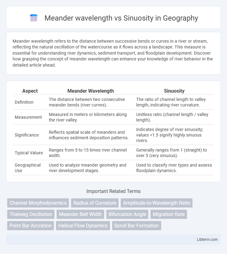
| Aspect | Meander Wavelength | Sinuosity |
|---|---|---|
| Definition | The distance between two consecutive meander bends (river curves). | The ratio of channel length to valley length, indicating river curvature. |
| Measurement | Measured in meters or kilometers along the river valley. | Unitless ratio (channel length / valley length). |
| Significance | Reflects spatial scale of meanders and influences sediment deposition patterns. | Indicates degree of river sinuosity; values >1.5 signify highly sinuous rivers. |
| Typical Values | Ranges from 5 to 15 times river channel width. | Generally ranges from 1 (straight) to over 3 (very sinuous). |
| Geographical Use | Used to analyze meander geometry and river development stages. | Used to classify river types and assess floodplain dynamics. |
Understanding Meander Wavelength and Sinuosity
Meander wavelength refers to the distance between two consecutive bends or curves in a river, typically measured from crest to crest, and is crucial for analyzing river dynamics and sediment transport. Sinuosity is the ratio of the channel length to the valley length, quantifying how much a river meanders compared to a straight line, with values greater than 1 indicating increased curvature and complexity. Understanding the relationship between meander wavelength and sinuosity helps in predicting river behavior, floodplain development, and erosion patterns within meandering river systems.
Defining Meander Wavelength in River Systems
Meander wavelength in river systems refers to the distance between two successive meander bends along the river course, typically measured from crest to crest or trough to trough of a sinuous river pattern. It directly influences the sinuosity, which is the ratio of channel length to valley length, indicating how much a river meanders. Understanding meander wavelength helps predict river behavior, sediment transport, and floodplain development, critical for effective river management and ecological studies.
What is Sinuosity?
Sinuosity measures the degree of curvature or deviation of a river channel from a straight path, expressed as the ratio of channel length to valley length. It quantifies how much a river meanders, with values greater than 1 indicating increased channel complexity and bending. Understanding sinuosity is essential for analyzing meander wavelength, as higher sinuosity corresponds to longer meander wavelengths and more pronounced bends in the river course.
Key Differences Between Meander Wavelength and Sinuosity
Meander wavelength refers to the distance between two successive bends or meander crests in a river, typically measured along the channel centerline. Sinuosity quantifies the degree of river curvature by comparing the actual channel length to the straight-line valley length, expressed as a ratio. Key differences lie in their measurement focus: wavelength captures spatial scale of bends, while sinuosity indicates overall channel complexity and curvature intensity.
Geological Factors Influencing Meander Wavelength
Meander wavelength is strongly influenced by geological factors such as substrate composition, valley slope, and sediment supply, which impact river channel resistance and erosion patterns. High erodibility of sedimentary rocks often leads to shorter meander wavelengths, while resistant bedrock promotes longer, more stable bends. Variations in slope and discharge modulate sinuosity, where gentle gradients and abundant sediments typically enhance curvature and increase sinuosity values in meandering rivers.
Environmental Impacts on Sinuosity
Meander wavelength, the distance between successive bends in a river, increases with sinuosity, which measures the river's curvature relative to channel length. Environmental factors such as sediment load, bank vegetation, and flow velocity directly influence sinuosity by affecting erosion and deposition patterns along the riverbanks. Changes in land use and climate can alter hydrological regimes, thereby modifying sinuosity and impacting floodplain ecosystems and habitat connectivity.
Methods to Measure Meander Wavelength and Sinuosity
Meander wavelength is commonly measured by identifying consecutive meander bends along a river channel using aerial imagery or GIS tools, calculating the distance between corresponding points such as meander crests or inflection points. Sinuosity is quantified by dividing the channel length by the valley length between the same points, often derived from topographic maps or digital elevation models (DEMs) to capture precise channel curvature. Advanced methods utilize remote sensing data combined with automated algorithms to improve accuracy and efficiency in characterizing river meanders.
The Relationship Between Meander Wavelength and Sinuosity
Meander wavelength and sinuosity are key metrics used to characterize river meanders, where wavelength refers to the length of one complete meander bend and sinuosity measures the channel's deviation from a straight path. The relationship between meander wavelength and sinuosity reveals that longer wavelengths typically correspond to increased sinuosity, reflecting greater channel curvature and complexity. Studies indicate that as sinuosity values rise beyond 1.5, meander wavelengths tend to expand proportionally, influenced by factors such as flow velocity, sediment size, and bank material cohesiveness.
Practical Applications in Fluvial Geomorphology
Meander wavelength and sinuosity are critical parameters in fluvial geomorphology that influence river channel stability, floodplain development, and habitat diversity. Accurately measuring meander wavelength allows for predicting floodplain evolution and sediment transport patterns, while sinuosity values help in assessing river dynamics and potential erosion risks. These metrics are essential for designing effective river management practices, restoring natural flow regimes, and mitigating flood hazards.
Case Studies: Meander Wavelength and Sinuosity in Major Rivers
Case studies of major rivers such as the Mississippi, Amazon, and Mekong reveal a strong correlation between meander wavelength and sinuosity, where longer wavelengths typically correspond to moderate sinuosity values ranging from 1.5 to 2.5. Research shows that the Mississippi River's meander wavelength averages around 10 to 15 times its channel width, with sinuosity values commonly near 2, indicating a balance between lateral migration and flow resistance. Similarly, the Amazon River exhibits wavelengths scaling with channel width and sinuosity values influenced by sediment load and floodplain characteristics, highlighting the dynamic interplay between hydraulic forces and valley geometry in shaping river meanders.
Meander wavelength Infographic