Bathymetry is the study and mapping of underwater topography, revealing the depths and shapes of ocean floors, lakes, and rivers. Accurate bathymetric data plays a crucial role in navigation, marine research, and environmental monitoring. Explore the rest of this article to understand how bathymetry impacts your exploration and safety on the water.
Table of Comparison
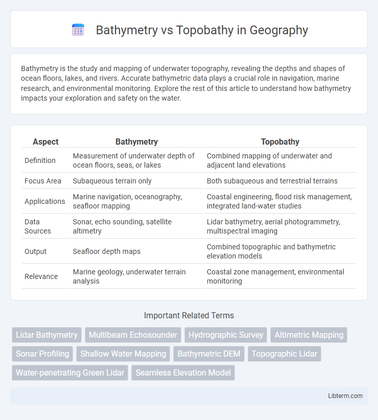
| Aspect | Bathymetry | Topobathy |
|---|---|---|
| Definition | Measurement of underwater depth of ocean floors, seas, or lakes | Combined mapping of underwater and adjacent land elevations |
| Focus Area | Subaqueous terrain only | Both subaqueous and terrestrial terrains |
| Applications | Marine navigation, oceanography, seafloor mapping | Coastal engineering, flood risk management, integrated land-water studies |
| Data Sources | Sonar, echo sounding, satellite altimetry | Lidar bathymetry, aerial photogrammetry, multispectral imaging |
| Output | Seafloor depth maps | Combined topographic and bathymetric elevation models |
| Relevance | Marine geology, underwater terrain analysis | Coastal zone management, environmental monitoring |
Introduction to Bathymetry and Topobathy
Bathymetry measures underwater depths and maps seafloor topography using sonar or satellite data to provide detailed ocean floor profiles essential for navigation and marine research. Topobathy combines bathymetric and topographic data to create integrated models of coastal and nearshore environments, offering comprehensive insights into both land elevation and underwater features. This approach enhances coastal management, environmental studies, and flood risk assessment by bridging terrestrial and marine mapping techniques.
Defining Bathymetry: Mapping the Underwater Terrain
Bathymetry is the scientific measurement and mapping of underwater terrain, detailing the depth and shape of ocean floors, lakes, and riverbeds using sonar, satellite, and LiDAR technologies. Topobathy extends traditional bathymetry by integrating topographic data from adjacent land areas, creating comprehensive coastal and riverine models. Accurate bathymetric data aids in navigation, marine habitat research, and coastal management.
Understanding Topobathy: Integrating Land and Water Elevation Data
Topobathy combines bathymetric data, which measures underwater depths, with topographic data of land elevations to create a seamless elevation model that spans aquatic and terrestrial environments. This integration supports more accurate flood risk assessments, coastal management, and habitat mapping by providing a continuous surface representing both land and underwater terrain. Utilizing high-resolution LIDAR and sonar surveys enhances the precision of topobathic models, enabling improved environmental planning and disaster response strategies.
Key Differences Between Bathymetry and Topobathy
Bathymetry measures underwater depth of ocean or lake floors using sonar or satellite technology, providing detailed profiles of underwater terrain. Topobathy combines topographic and bathymetric data to create continuous elevation models that include both land surface and underwater features. Key differences include bathymetry's exclusive focus on underwater depth versus topobathy's integrated mapping of land and underwater elevations for coastal and marine planning.
Measurement Techniques for Bathymetric Mapping
Bathymetric mapping primarily employs sonar systems, including multibeam and single-beam echosounders, to measure underwater depths by emitting sound pulses and recording their return times, enabling high-resolution seafloor topography. Satellite altimetry contributes to bathymetry by detecting sea surface height variations caused by seafloor features, though with less precision than direct sonar methods. In contrast, topobathy integrates LiDAR technology, especially airborne bathymetric LiDAR, which captures both terrestrial and shallow water elevation data using laser pulses, facilitating detailed mapping in coastal zones where bathymetry and topography converge.
Tools and Technologies Used in Topobathy Surveys
Topobathy surveys use a combination of LiDAR technology and multispectral bathymetric sensors to collect accurate elevation data across both land and shallow water areas. Airborne LiDAR systems equipped with green lasers penetrate water surfaces, enabling high-resolution mapping of underwater terrains and coastal zones. Integration of GPS and advanced processing software enhances positional accuracy and data quality, supporting precise topobathymetric models for environmental and engineering applications.
Applications of Bathymetry in Marine Science
Bathymetry measures the underwater depth of ocean floors, playing a crucial role in marine science by mapping seafloor topography to support habitat characterization, submarine navigation, and geological studies. Topobathy combines bathymetric and topographic data, integrating land elevation with underwater terrain for comprehensive coastal zone management and flood risk assessment. Bathymetric data supports ecosystem monitoring, tsunami modeling, and benthic habitat mapping, facilitating sustainable ocean resource management and marine biodiversity conservation.
Topobathy in Coastal and Floodplain Management
Topobathy integrates bathymetric and topographic data to provide detailed elevation models essential for coastal and floodplain management. This hybrid approach improves the accuracy of flood risk assessments, shoreline mapping, and habitat restoration projects by capturing underwater and terrestrial terrain variations. High-resolution topobathy datasets enable more effective planning and mitigation strategies against sea-level rise and extreme weather events in vulnerable coastal zones.
Challenges in Collecting and Integrating Bathymetric and Topobathymetric Data
Collecting bathymetric data involves challenges such as limited accessibility in deep or turbulent waters, sensor accuracy affected by water conditions, and the need for high-resolution sonar equipment. Topobathymetric data integration requires precise alignment of terrestrial elevation and underwater depth datasets, often complicated by varying data formats, scales, and datum inconsistencies. Addressing these challenges demands advanced sensor calibration, robust geospatial data processing techniques, and comprehensive validation to ensure seamless, accurate representations of combined land and underwater terrains.
Future Trends in Bathymetry and Topobathy Mapping
Future trends in bathymetry and topobathy mapping include the integration of high-resolution LiDAR and multispectral sensor data to enhance underwater and hybrid coastal terrain models. Advances in machine learning algorithms enable more accurate interpolation and anomaly detection in complex seafloor and shoreline environments, improving resource management and hazard assessment. The increasing use of autonomous underwater vehicles (AUVs) and unmanned aerial systems (UAS) facilitates real-time data acquisition with greater spatial coverage and cost efficiency.
Bathymetry Infographic