Hypsometry measures the distribution of land elevation relative to sea level, providing crucial insights into the Earth's surface variations and topography. Understanding hypsometric data aids in geological studies, environmental planning, and predicting erosion or flood risks. Explore the article to learn how hypsometry influences your interpretation of terrain and landscape features.
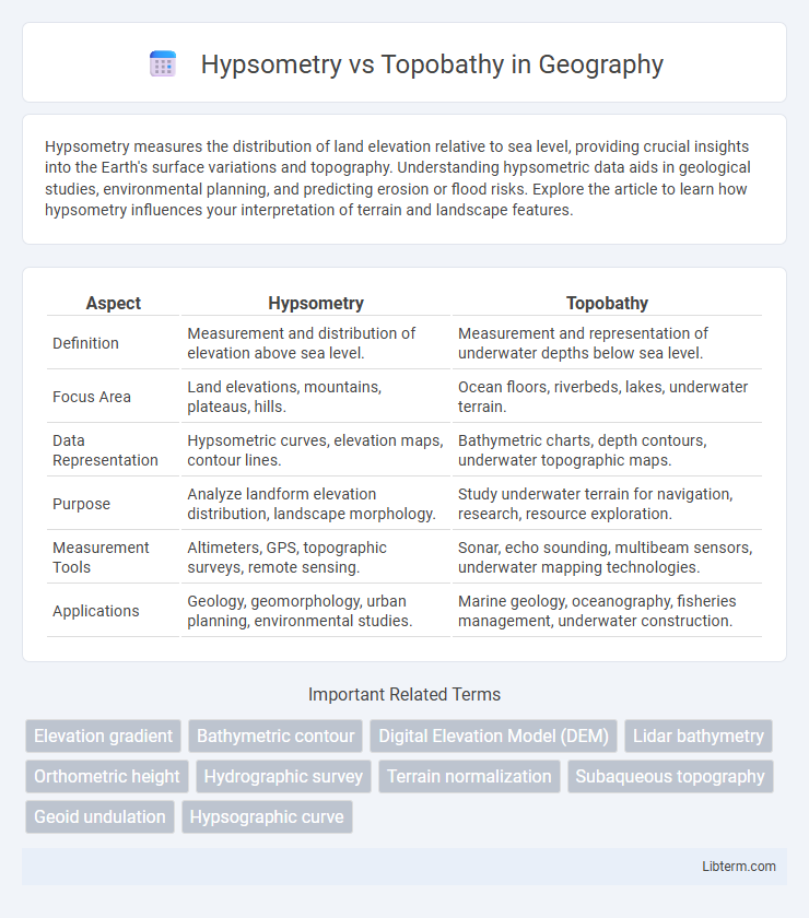
Table of Comparison
| Aspect | Hypsometry | Topobathy |
|---|---|---|
| Definition | Measurement and distribution of elevation above sea level. | Measurement and representation of underwater depths below sea level. |
| Focus Area | Land elevations, mountains, plateaus, hills. | Ocean floors, riverbeds, lakes, underwater terrain. |
| Data Representation | Hypsometric curves, elevation maps, contour lines. | Bathymetric charts, depth contours, underwater topographic maps. |
| Purpose | Analyze landform elevation distribution, landscape morphology. | Study underwater terrain for navigation, research, resource exploration. |
| Measurement Tools | Altimeters, GPS, topographic surveys, remote sensing. | Sonar, echo sounding, multibeam sensors, underwater mapping technologies. |
| Applications | Geology, geomorphology, urban planning, environmental studies. | Marine geology, oceanography, fisheries management, underwater construction. |
Introduction to Hypsometry and Topobathy
Hypsometry refers to the measurement of land elevation relative to sea level, often represented through contour lines or digital elevation models to analyze terrain and landscape features. Topobathy combines topographic and bathymetric data to provide comprehensive maps of both land surfaces and underwater bathymetry, essential for coastal engineering and marine navigation. Understanding hypsometry and topobathy enables precise modeling of elevation changes above and below sea level for environmental planning and geospatial analysis.
Defining Hypsometry: Concepts and Applications
Hypsometry involves the measurement and analysis of land elevation relative to sea level to understand terrain variability and altitude distribution. It is commonly used in geographic information systems (GIS), environmental studies, and landform evolution assessments to map elevation data for slope analysis and watershed management. Topobathy complements this by combining topographic and bathymetric data to provide a comprehensive representation of both land and underwater features.
Understanding Topobathy: Scope and Methods
Topobathy integrates topographic data with bathymetric measurements to accurately model both land and underwater terrain, offering a comprehensive perspective on elevation changes across coastal and aquatic environments. Techniques such as LiDAR combined with sonar mapping facilitate precise data collection, enabling detailed analysis of seabed contours alongside terrestrial features. This method supports applications in coastal management, flood risk assessment, and habitat mapping by providing high-resolution digital elevation models that encompass subaqueous landscapes.
Key Differences Between Hypsometry and Topobathy
Hypsometry measures the elevation of land surfaces relative to sea level, providing data on terrain heights and landform distribution, while topobathy integrates topographic and bathymetric information to map both land elevations and underwater depths. Hypsometric analyses typically focus on continental and terrestrial elevation profiles, whereas topobathymetric studies encompass coastal zones, riverbeds, and ocean floors for comprehensive surface mapping. Key differences include the scope of measurement--hypsometry addresses above-sea-level elevations, and topobathy covers elevations above and below sea level--making topobathy essential for coastal and marine spatial analysis.
Data Sources for Hypsometry and Topobathy Analyses
Hypsometry relies primarily on terrestrial elevation data obtained from satellite-based LiDAR, aerial photogrammetry, and ground surveys such as GPS and total stations. Topobathy analysis integrates bathymetric data sourced from sonar mapping, multibeam echo sounders, and satellite altimetry, combined with terrestrial elevation models for nearshore areas. Accurate integration of these data sources enables comprehensive terrain and underwater topographic mapping essential for environmental monitoring and coastal management.
Tools and Techniques in Hypsometric Mapping
Hypsometric mapping uses tools such as Digital Elevation Models (DEMs), remote sensing technologies like LiDAR and satellite imagery, and Geographic Information Systems (GIS) for precise elevation data collection and analysis. Techniques in hypsometry involve contour line generation, color gradation to represent elevation intervals, and 3D terrain modeling to visualize topographic variations accurately. These advanced tools enable detailed assessments of landforms and elevation changes, distinguishing hypsometry from topobathy, which focuses on both land elevation and underwater topography.
Technologies Used in Topobathymetric Surveys
Topobathymetric surveys integrate LiDAR (Light Detection and Ranging) and sonar technologies to capture both terrestrial and underwater elevation data, enabling precise mapping of coastal and riverine environments. Airborne LiDAR systems equipped with green wavelengths penetrate water surfaces, while multibeam and singlebeam echosounders provide detailed bathymetric measurements. These advanced technologies facilitate the creation of accurate digital elevation models (DEMs) that support flood risk assessment, habitat mapping, and coastal engineering projects.
Real-world Applications of Hypsometry
Hypsometry measures land elevation relative to sea level, providing critical data for geological mapping, environmental monitoring, and urban planning. These measurements support flood risk assessment, watershed management, and infrastructure development by accurately modeling terrain elevations. In contrast, topobathy combines topographic and bathymetric data to analyze shorelines and underwater features, primarily aiding coastal and marine studies.
Practical Uses of Topobathy in Modern Science
Topobathy integrates topographic and bathymetric data to create detailed maps of land elevation and underwater terrain, essential for coastal management, flood risk assessment, and environmental monitoring. Its application in modern science enables precise modeling of shoreline dynamics, habitat mapping, and infrastructure development in coastal and riverine zones. Researchers utilize topobathy for real-time monitoring of sea level changes and sediment transport, improving disaster preparedness and marine resource management.
Future Trends in Terrain and Bathymetric Mapping
Advancements in remote sensing technologies and machine learning are revolutionizing hypsometry and topobathy, enabling more accurate and high-resolution terrain and bathymetric mapping. Emerging trends include the integration of multispectral satellite data with LiDAR and sonar systems, improving the precision of elevation and underwater depth models crucial for environmental monitoring and coastal management. Future developments will emphasize real-time data processing and autonomous surveying platforms, enhancing decision-making in climate resilience and marine navigation.
Hypsometry Infographic