A sphere is a perfectly round three-dimensional shape where every point on its surface is equidistant from the center. Understanding its properties, such as volume and surface area calculations, is essential in fields ranging from geometry to physics. Explore the rest of the article to deepen your knowledge about spheres and their applications.
Table of Comparison
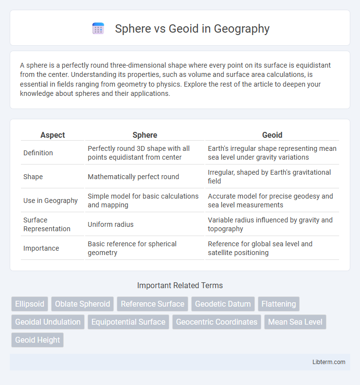
| Aspect | Sphere | Geoid |
|---|---|---|
| Definition | Perfectly round 3D shape with all points equidistant from center | Earth's irregular shape representing mean sea level under gravity variations |
| Shape | Mathematically perfect round | Irregular, shaped by Earth's gravitational field |
| Use in Geography | Simple model for basic calculations and mapping | Accurate model for precise geodesy and sea level measurements |
| Surface Representation | Uniform radius | Variable radius influenced by gravity and topography |
| Importance | Basic reference for spherical geometry | Reference for global sea level and satellite positioning |
Introduction to Sphere and Geoid
A sphere is a perfectly symmetrical three-dimensional shape where every point on the surface is equidistant from the center, commonly used as a simplified model of Earth in basic geography and physics. The geoid represents Earth's shape more accurately by reflecting variations in gravitational force, resulting in an irregular but precise surface corresponding to mean sea level. Understanding the distinction enables more accurate geospatial measurements and navigation systems.
Defining a Sphere
A sphere is a perfectly symmetrical three-dimensional shape where all points on its surface are equidistant from its center, making it the ideal geometric model for celestial bodies in basic calculations. Unlike the geoid, which represents Earth's irregular gravitational shape, the sphere simplifies complex measurements by assuming uniform curvature. This abstraction is essential in fields like astronomy and physics for modeling and calculating planetary motions and distances.
Understanding the Geoid
The geoid represents the Earth's mean sea level extended continuously under the continents, reflecting variations in gravitational force caused by Earth's uneven mass distribution. Unlike a perfect sphere, the geoid surface undulates to account for local discrepancies in gravity, making it the most accurate model for measuring precise elevations. Understanding the geoid is crucial for geodesy, satellite navigation, and oceanography, as it serves as the reference for determining true vertical positions and sea level changes.
Key Differences Between Sphere and Geoid
The key differences between a sphere and a geoid lie in their shapes and definitions; a sphere is a perfectly symmetrical three-dimensional object with all points equidistant from its center, whereas the geoid represents the Earth's irregular shape, influenced by gravitational variations and surface topography. Unlike a smooth sphere, the geoid surface undulates to reflect gravitational differences caused by factors such as mountain ranges and ocean trenches. Geoid modeling is essential for accurate measurements in geodesy, oceanography, and satellite navigation, providing a more precise representation of Earth's mean sea level compared to a simple spherical approximation.
Mathematical Representations
The sphere is mathematically represented by a simple equation \( x^2 + y^2 + z^2 = r^2 \), where \( r \) is the radius, providing a perfect symmetrical shape ideal for basic geodetic models. The geoid, however, is defined by a more complex mathematical surface that corresponds to the Earth's mean sea level, incorporating gravitational potential variations and requiring spherical harmonics and geopotential models such as EGM96 for accurate representation. These mathematical differences make the sphere suitable for simplified calculations, while the geoid provides precise Earth shape modeling essential for high-accuracy navigation and geodesy.
Importance in Earth Sciences
The geoid represents Earth's true shape by modeling gravitational variations and sea level, making it essential for accurate measurements in geodesy, oceanography, and climate studies. Unlike a perfect sphere, the geoid accounts for gravitational anomalies caused by mountain ranges, ocean trenches, and density variations within the Earth's mantle, crucial for precise satellite navigation and mapping. Understanding the differences between a sphere and the geoid allows scientists to predict sea-level rise, tectonic movement, and Earth's internal structure with greater accuracy.
Applications in Mapping and Navigation
The geoid provides a more accurate representation of Earth's true shape by reflecting variations in gravitational pull, essential for precise elevation measurements and sea level calculations in mapping. Sphere models simplify calculations for global navigation systems, enabling efficient route planning and spatial referencing despite their less accurate shape portrayal. Combining geoid data with spherical models enhances GPS accuracy, improving navigation in aviation, maritime, and land-based applications.
Advantages and Limitations
The sphere model offers simplicity and ease of calculation, making it ideal for quick approximations in global mapping, while its uniform curvature lacks the precision to represent Earth's true shape. The geoid provides a more accurate representation of Earth's irregular gravitational field by reflecting sea level variations, crucial for precise geospatial measurements and satellite navigation. However, the geoid's complexity requires extensive data and sophisticated modeling, limiting its use in basic applications compared to the sphere.
Real-World Implications
The geoid represents Earth's true shape, accounting for gravitational variations, making it essential for precise satellite positioning, sea-level measurements, and geophysical studies. In contrast, using a perfect sphere as a model simplifies calculations but introduces errors in navigation and mapping, impacting aviation and maritime industries. Understanding the geoid improves accuracy in GPS technology, climate monitoring, and engineering projects that rely on exact elevation data.
Conclusion: Choosing the Right Model
Selecting between a sphere and a geoid model depends on the required precision and application context. A sphere offers simplicity and ease of calculation for general purposes, while the geoid provides a more accurate representation of Earth's gravitational variations and surface irregularities essential for precise geospatial and geophysical analyses. Geoid models are preferred in advanced navigation, surveying, and oceanography to ensure accuracy in elevation and positional data.
Sphere Infographic