Mooring is a critical process in maritime operations involving securing a vessel to a fixed or floating object to prevent drifting. Effective mooring ensures safety, stability, and operational efficiency during loading, unloading, or docking procedures. Explore the rest of the article to understand various mooring techniques and how they can benefit your maritime activities.
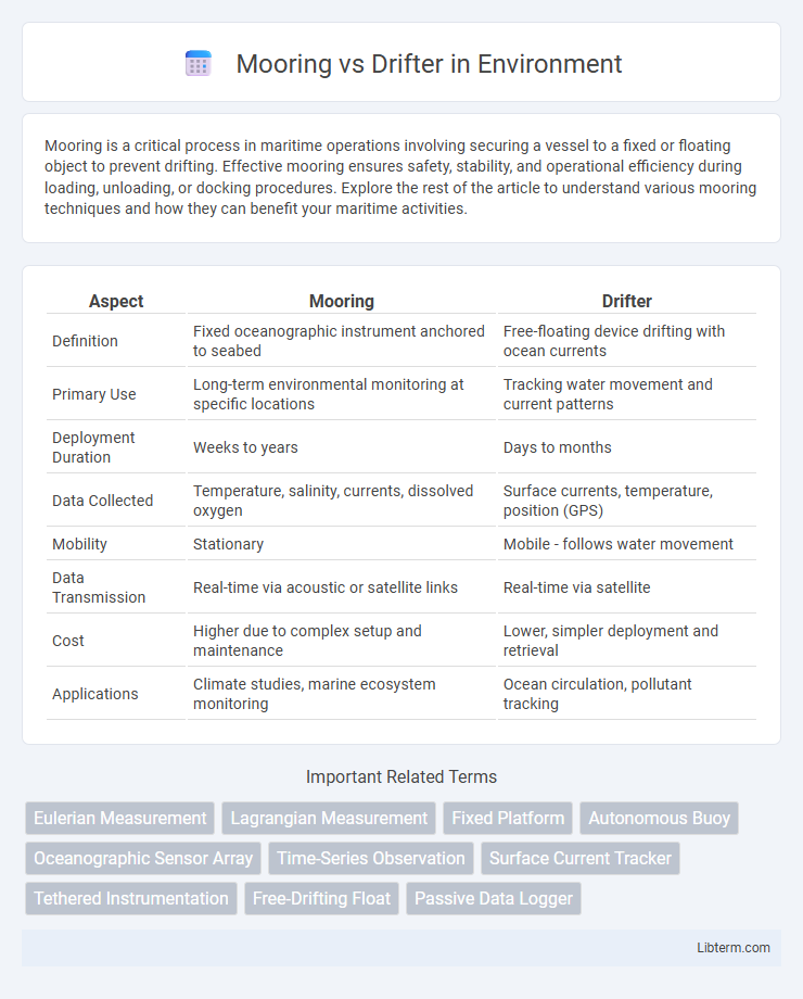
Table of Comparison
| Aspect | Mooring | Drifter |
|---|---|---|
| Definition | Fixed oceanographic instrument anchored to seabed | Free-floating device drifting with ocean currents |
| Primary Use | Long-term environmental monitoring at specific locations | Tracking water movement and current patterns |
| Deployment Duration | Weeks to years | Days to months |
| Data Collected | Temperature, salinity, currents, dissolved oxygen | Surface currents, temperature, position (GPS) |
| Mobility | Stationary | Mobile - follows water movement |
| Data Transmission | Real-time via acoustic or satellite links | Real-time via satellite |
| Cost | Higher due to complex setup and maintenance | Lower, simpler deployment and retrieval |
| Applications | Climate studies, marine ecosystem monitoring | Ocean circulation, pollutant tracking |
Introduction to Oceanographic Monitoring
Moorings and drifters are essential oceanographic instruments used for monitoring dynamic marine environments. Moorings consist of anchored sensor arrays fixed to the seabed, enabling continuous collection of data such as temperature, salinity, and current velocity at specific locations. Drifters are free-floating devices that track surface currents and collect real-time data on oceanic conditions by moving with water masses, providing valuable insights into ocean circulation and dispersion patterns.
What is a Mooring?
A mooring is a fixed oceanographic instrument platform anchored to the seabed that continuously collects data on water temperature, salinity, currents, and other environmental parameters. Unlike drifters, which move freely with ocean currents to track water movement, moorings provide long-term, stationary observations crucial for monitoring seasonal and climate-related changes. Moorings typically consist of a buoy or float connected to instruments suspended at various depths, enabling detailed vertical profiling in a specific location.
What is a Drifter?
A drifter is an oceanographic instrument designed to float freely with currents, collecting data on surface water temperature, salinity, and flow patterns. Unlike moorings that are anchored to the seabed, drifters provide real-time information on ocean circulation by transmitting GPS positions and environmental parameters via satellite. These devices are essential for studying large-scale ocean dynamics, weather forecasting, and climate research.
Design and Deployment Differences
Moorings are fixed oceanographic instruments anchored to the seafloor, designed for long-term, stationary data collection with components such as anchors, buoys, and sensor arrays. Drifters are free-floating devices equipped with surface or subsurface drogues, deployed to move with currents and capture spatial-temporal variations in oceanographic parameters. While moorings require precise anchor placement and robust tethering systems for stability, drifters emphasize streamlined design for minimal drag and efficient tracking via satellite telemetry.
Data Collection Capabilities
Mooring systems provide continuous, fixed-point data collection with high temporal resolution, ideal for monitoring specific oceanographic variables such as temperature, salinity, and current speed over extended periods. Drifters offer spatially extensive data by moving with ocean currents, enabling the mapping of surface circulation patterns and variability in real time. Combining both platforms enhances comprehensive marine environment analysis by integrating stationary time series with dynamic spatial observations.
Applications and Research Use Cases
Moorings provide fixed-point data collection for long-term monitoring of oceanographic parameters such as temperature, salinity, and current profiles, making them ideal for studying climate change impacts and marine ecosystem health. Drifters are used to track surface currents and dispersal patterns in real-time, essential for research in pollutant transport, biological connectivity, and ocean circulation models. Both technologies complement each other by offering spatially fixed datasets (moorings) and dynamic spatial coverage (drifters) critical for comprehensive marine and climate research.
Advantages of Moorings
Moorings provide continuous, long-term data collection in fixed ocean locations, allowing for detailed monitoring of environmental changes over time. Their stability ensures accurate measurements of variables such as temperature, salinity, and current speed, which are essential for climate research and marine ecosystem assessment. Compared to drifters, moorings offer reliable data unaffected by drifting, making them vital for sustained oceanographic studies.
Advantages of Drifters
Drifters offer cost-effective deployment and require minimal maintenance compared to moorings, making them ideal for large-scale oceanographic data collection. Their ability to move with currents provides valuable insights into ocean surface circulation patterns and real-time monitoring of environmental changes. Drifters also enable flexible, widespread spatial data acquisition, capturing dynamic ocean conditions that stationary moorings cannot.
Limitations and Challenges
Moorings face limitations such as fixed spatial coverage and vulnerability to storm damage, which can compromise long-term data collection in harsh marine environments. Drifters encounter challenges including limited control over trajectory, leading to variable spatial sampling and potential data gaps in targeted study areas. Both platforms require integration with remote sensing and modeling to overcome their respective spatial and temporal constraints in oceanographic research.
Choosing Between Moorings and Drifters
Selecting between moorings and drifters depends on research objectives and oceanographic conditions. Moorings provide fixed, continuous data at specific depths ideal for studying temporal changes and long-term monitoring, while drifters offer spatial data by tracking water movement and surface currents dynamically. Opt for moorings for stationary measurements and drifters for mapping large-scale circulation and surface flow patterns.
Mooring Infographic