Geomorphology analyzes the formation and evolution of Earth's landforms through processes like erosion, sedimentation, and tectonic activity. Understanding these dynamics is essential for predicting natural hazards and managing natural resources effectively. Discover more about how geomorphology shapes your environment and impacts daily life in the rest of this article.
Table of Comparison
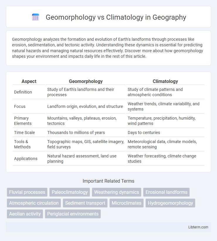
| Aspect | Geomorphology | Climatology |
|---|---|---|
| Definition | Study of Earth's landforms and their processes | Study of climate patterns and atmospheric conditions |
| Focus | Landform origin, evolution, and structure | Weather trends, climate variability, and systems |
| Primary Elements | Mountains, valleys, plateaus, erosion, tectonics | Temperature, precipitation, humidity, wind patterns |
| Time Scale | Thousands to millions of years | Days to centuries |
| Tools & Methods | Topographic maps, GIS, satellite imagery, field surveys | Meteorological data, climate models, remote sensing |
| Applications | Natural hazard assessment, land use planning | Weather forecasting, climate change studies |
Introduction to Geomorphology and Climatology
Geomorphology studies the Earth's landforms and the processes shaping them, analyzing terrain features such as mountains, valleys, and plateaus through geological and hydrological processes. Climatology examines long-term atmospheric patterns, focusing on temperature, precipitation, and wind systems to understand climate variability and trends. Both disciplines interconnect as geomorphic processes are influenced by climate factors, emphasizing the dynamic interaction between landforms and climatic conditions.
Defining Geomorphology: Scope and Significance
Geomorphology studies the formation, evolution, and classification of landforms, analyzing processes such as erosion, sedimentation, and tectonic activity. Its scope includes understanding the Earth's surface dynamics to predict geological hazards and manage natural resources. The significance of geomorphology lies in its role in environmental planning, disaster risk reduction, and informing climate change impact assessments.
Understanding Climatology: Key Concepts and Focus
Climatology examines long-term atmospheric patterns and their effects on weather systems, temperature, precipitation, and humidity across various regions. It analyzes climate variability and change, emphasizing factors such as solar radiation, air pressure, and greenhouse gases. This discipline plays a crucial role in predicting climate trends, assessing environmental impacts, and informing sustainable practices.
Core Differences Between Geomorphology and Climatology
Geomorphology studies the Earth's landforms, their processes, and the history of terrain development, emphasizing physical features like mountains, valleys, and rivers. Climatology focuses on climate patterns, atmospheric conditions, and long-term weather trends, analyzing factors such as temperature, precipitation, and wind. The core difference lies in geomorphology's concern with solid Earth surface dynamics, whereas climatology centers on atmospheric phenomena and climate systems.
Intersections and Interactions: Landforms and Climate
Landforms shaped by geomorphological processes influence local climate patterns by altering atmospheric circulation, temperature, and precipitation distribution. Climate affects geomorphological dynamics through weathering, erosion, and sediment transport, which reshape landscapes over time. The interaction between geomorphology and climatology is critical for understanding environmental changes, natural hazard mitigation, and ecosystem dynamics.
Methods and Tools Used in Geomorphology
Geomorphology employs methods such as remote sensing, Geographic Information Systems (GIS), and field surveying to analyze landforms and processes shaping the Earth's surface. Techniques like aerial photography, LiDAR, and digital elevation models (DEMs) facilitate detailed topographic mapping and terrain analysis. These tools enable the assessment of erosion rates, sediment transport, and landscape evolution, distinguishing geomorphology's spatially-focused approach from climatology's atmospheric data modeling and weather pattern analysis.
Research Techniques in Climatology
Research techniques in climatology primarily involve the collection and analysis of atmospheric data through remote sensing, climate models, and field observations. Advanced technologies like satellite imaging and global climate models (GCMs) enable detailed monitoring of temperature, precipitation, and wind patterns over time. These methods provide critical insights into climate variability and change, distinguishing climatology's focus on atmospheric processes from geomorphology's emphasis on landform development.
Real-World Applications: From Landscape Evolution to Weather Forecasting
Geomorphology analyzes landforms and processes shaping the Earth's surface, crucial for urban planning, natural hazard assessment, and soil conservation. Climatology studies atmospheric patterns and climate systems, enabling accurate weather forecasting, climate change prediction, and disaster preparedness. Integrating geomorphology with climatology enhances understanding of landscape evolution influenced by climate dynamics, improving resource management and environmental resilience.
Challenges and Advancements in Both Fields
Geomorphology faces challenges in accurately modeling landscape evolution due to complex interactions between tectonics, erosion, and sedimentation, while advancements in remote sensing and GIS technology have significantly improved terrain analysis and prediction models. Climatology struggles with the uncertainty of climate variability and extreme weather forecasting, yet progress in high-resolution climate models and satellite observations has enhanced understanding of atmospheric processes and climate change impacts. Both fields increasingly integrate interdisciplinary data and computational techniques to address spatial-temporal complexities and improve predictive capabilities.
Future Trends in Geomorphology and Climatology
Future trends in geomorphology emphasize the integration of advanced remote sensing technologies and machine learning to model landscape evolution and predict geomorphic hazards with higher accuracy. In climatology, evolving climate models harness increased computational power and extensive satellite data to improve forecasting of extreme weather events and assess climate change impacts on regional and global scales. Interdisciplinary approaches linking geomorphic processes and climate dynamics drive innovations in environmental management and disaster risk reduction strategies.
Geomorphology Infographic