Landform classification organizes Earth's surface features into categories based on their shape, origin, and formation processes. Understanding these distinctions helps you better interpret natural landscapes and their ecological impacts. Explore the full article to uncover detailed classifications and their significance.
Table of Comparison
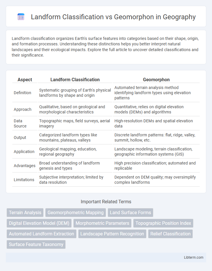
| Aspect | Landform Classification | Geomorphon |
|---|---|---|
| Definition | Systematic grouping of Earth's physical landforms by shape and origin | Automated terrain analysis method identifying landform types using elevation patterns |
| Approach | Qualitative, based on geological and morphological characteristics | Quantitative, relies on digital elevation models (DEMs) and algorithms |
| Data Source | Topographic maps, field surveys, aerial imagery | High-resolution DEMs and spatial elevation data |
| Output | Categorized landform types like mountains, plateaus, valleys | Discrete landform patterns: flat, ridge, valley, summit, hollow, etc. |
| Application | Geological mapping, education, regional geography | Landscape modeling, terrain classification, geographic information systems (GIS) |
| Advantages | Broad understanding of landform genesis and types | High precision classification; automated and replicable |
| Limitations | Subjective interpretation; limited by data resolution | Dependent on DEM quality; may oversimplify complex landforms |
Introduction to Landform Classification
Landform classification is a systematic approach to categorizing the Earth's surface based on shape, elevation, slope, and geological processes, providing essential insight into terrain analysis and environmental studies. It uses metrics such as relief, slope gradient, and curvature to distinguish features like valleys, ridges, plains, and plateaus. Geomorphon classification builds on this by automating landform mapping through pattern recognition of digital elevation models (DEMs) to identify subtle landform elements at multiple scales.
Understanding Geomorphons
Geomorphons offer a precise method for classifying landforms by analyzing local terrain patterns based on elevation and slope curvature, capturing micro-topographic features often missed in traditional landform classification. This approach uses a fixed-scale, pattern-recognition algorithm that identifies ten distinct landform types, enabling detailed landscape mapping and improved geomorphological interpretation. Understanding geomorphons enhances spatial analysis in environmental modeling, natural hazard assessment, and land-use planning by providing consistent and objective terrain classification.
Traditional Methods in Landform Classification
Traditional methods in landform classification primarily rely on qualitative observations of terrain features, using parameters such as slope angle, elevation, and shape to categorize landscapes into types like valleys, plateaus, and hills. These conventional approaches involve manual map interpretation and field surveys to assess geomorphic characteristics based on visual and topographic cues. Compared to geomorphon techniques, which automate landform classification through pattern analysis of digital elevation models, traditional methods emphasize expert judgment and physical terrain analysis for accurate landform delineation.
Key Principles of Geomorphon Analysis
Geomorphon analysis classifies landforms based on local terrain morphology by examining patterns of elevation at multiple scales, identifying fundamental landform elements like ridges, valleys, and slopes. This method relies on a moving window algorithm that compares a central cell with its surrounding terrain to detect geomorphic signatures, enabling precise, automated landform classification. Unlike traditional landform classification, which often depends on subjective criteria or broad geomorphological categories, geomorphon analysis provides detailed, objective mapping of micro and meso-scale landforms.
Differences Between Landform Classification and Geomorphon
Landform classification systems categorize terrain based on broad geomorphic features such as hills, valleys, and plateaus identified through landform types and elevation data. Geomorphon focuses on fine-scale terrain morphology by analyzing local topographic patterns derived from digital elevation models, offering a more detailed and context-specific representation of landforms. The key difference lies in scale and methodology: traditional landform classification relies on generalized categories, whereas geomorphon extraction uses a rule-based algorithm to identify micro-landforms independent of predefined classes.
Advantages of Geomorphon Over Conventional Methods
Geomorphon classification offers distinct advantages over traditional landform classification methods by providing a more precise and objective analysis of terrain shapes using local morphological patterns. It enables automated, scale-independent mapping of landforms, reducing subjectivity linked to manual interpretation and enhancing reproducibility across different geographic scales. This method efficiently captures subtle micro-topographic features often overlooked by conventional approaches, improving applications in geomorphology, ecological modeling, and hazard assessment.
Challenges in Landform Mapping
Landform classification faces challenges such as variability in scale, subjective interpretation of landform boundaries, and limited consistency across different datasets. Geomorphon methods improve objectivity by using local topographic patterns extracted from digital elevation models, but they still struggle with distinguishing subtle terrain features and require high-resolution data. Integrating geomorphons with traditional classification can enhance accuracy but demands computational resources and expertise in data processing.
Applications of Geomorphon in Geospatial Science
Geomorphon-based landform classification enables precise identification of terrain features by analyzing local geometric patterns, enhancing applications in geospatial science such as flood risk assessment, habitat mapping, and urban planning. This method leverages digital elevation models (DEMs) to provide automated, scale-adaptive landform categorization, supporting detailed landscape analysis and environmental monitoring. Integrating geomorphon classification with geographic information systems (GIS) improves spatial data interpretation for natural resource management and geological hazard prediction.
Case Studies: Landform Classification vs Geomorphon
Case studies comparing landform classification and geomorphon methods reveal distinct advantages in terrain analysis accuracy and computational efficiency. Landform classification typically relies on slope, aspect, and elevation metrics to categorize landscapes, whereas geomorphon techniques identify landforms based on local topographic patterns using terrain derivatives. Empirical research demonstrates that geomorphon approaches provide finer-scale details in complex terrains, enhancing applications in environmental planning and geohazard assessment.
Future Trends in Landform Identification Techniques
Future trends in landform identification techniques prioritize integrating geomorphon analysis with advanced machine learning algorithms to enhance accuracy and automate classification processes. The increasing availability of high-resolution digital elevation models (DEMs) enables more precise detection of microtopographic features, facilitating refined landform classification across diverse terrains. Progress in remote sensing technology, including LiDAR and multispectral imaging, supports real-time monitoring and dynamic updating of landforms, revolutionizing geomorphological studies and environmental management.
Landform Classification Infographic