Bathymetry is the study and measurement of underwater depth of ocean floors, lakes, and rivers, providing detailed maps of the submerged terrain. Accurate bathymetric data is essential for navigation, marine construction, habitat mapping, and environmental monitoring. Explore the rest of this article to understand how bathymetry impacts your maritime and scientific endeavors.
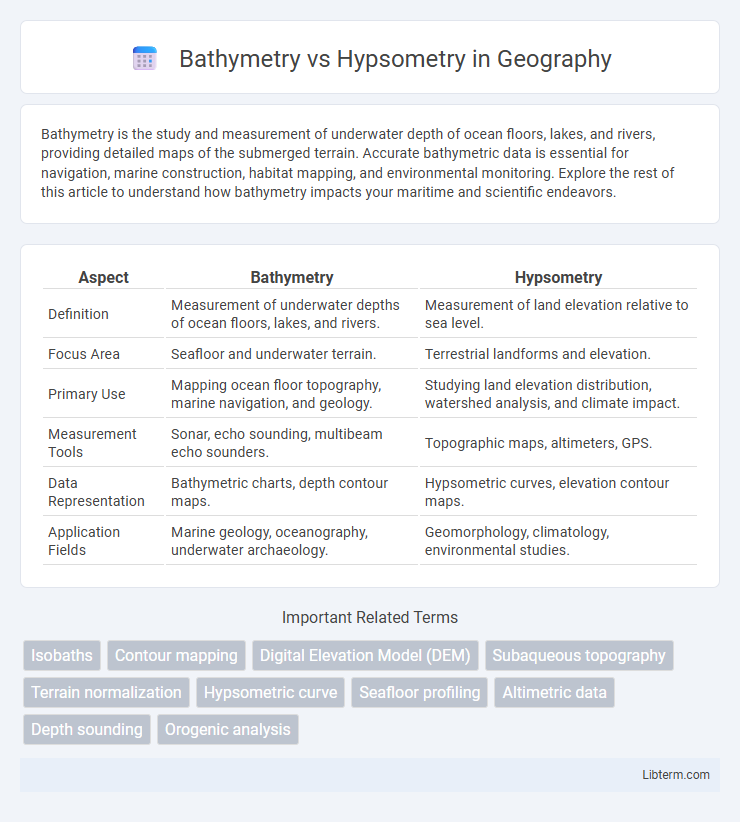
Table of Comparison
| Aspect | Bathymetry | Hypsometry |
|---|---|---|
| Definition | Measurement of underwater depths of ocean floors, lakes, and rivers. | Measurement of land elevation relative to sea level. |
| Focus Area | Seafloor and underwater terrain. | Terrestrial landforms and elevation. |
| Primary Use | Mapping ocean floor topography, marine navigation, and geology. | Studying land elevation distribution, watershed analysis, and climate impact. |
| Measurement Tools | Sonar, echo sounding, multibeam echo sounders. | Topographic maps, altimeters, GPS. |
| Data Representation | Bathymetric charts, depth contour maps. | Hypsometric curves, elevation contour maps. |
| Application Fields | Marine geology, oceanography, underwater archaeology. | Geomorphology, climatology, environmental studies. |
Introduction to Bathymetry and Hypsometry
Bathymetry measures underwater depth of ocean floors, lakes, and rivers using sonar, satellite altimetry, or echo sounding, providing detailed maps of underwater topography. Hypsometry analyzes land elevation relative to sea level, illustrating Earth's surface heights through hypsometric curves and elevation distribution. Both techniques are crucial for studying Earth's surface but focus on underwater and terrestrial relief respectively.
Defining Bathymetry: Mapping Underwater Terrain
Bathymetry involves the precise measurement and mapping of underwater terrain, detailing the depths and shapes of ocean floors, lakes, and riverbeds. This technique uses sonar, lidar, and satellite data to create detailed topographic maps representing the seafloor's contours and features. In contrast, hypsometry focuses on measuring land elevation relative to sea level, primarily mapping terrestrial landscapes rather than submerged environments.
Understanding Hypsometry: Elevation on Land
Hypsometry measures the distribution of Earth's land elevations relative to sea level, providing crucial data for understanding topographic variation and landscape morphology. Unlike bathymetry, which maps underwater terrain, hypsometric analysis helps quantify elevation ranges and informs studies on erosion, watershed management, and landform classification. Elevation profiles derived from hypsometric curves enable geologists and geographers to interpret terrain steepness and stability, essential in environmental planning and hazard assessment.
Key Differences Between Bathymetry and Hypsometry
Bathymetry measures the underwater topography of ocean floors, seas, and lake beds by mapping depths, while hypsometry assesses the distribution of surface elevations above sea level on landmasses. Bathymetric data is crucial for marine navigation, oceanography, and undersea resource exploration, whereas hypsometric analysis supports geomorphology, watershed management, and climate impact studies. The fundamental difference lies in bathymetry's focus on submerged landscapes contrasted with hypsometry's emphasis on terrestrial elevation patterns.
Methods and Tools Used in Bathymetry
Bathymetry involves measuring underwater depths using methods such as sonar mapping, multibeam echo sounders, and satellite altimetry to create detailed seafloor maps, while hypsometry measures terrestrial elevation using topographic surveys and digital elevation models. Tools like LiDAR and GPS are key in bathymetry for precise depth measurements and spatial accuracy. Advances in autonomous underwater vehicles (AUVs) and remote sensing have enhanced data resolution and coverage in bathymetric studies.
Techniques for Measuring Hypsometric Data
Hypsometric data is primarily measured using remote sensing techniques such as satellite imagery and aerial photogrammetry, which analyze elevation changes across landscapes by interpreting reflected light and shadow patterns. Digital Elevation Models (DEMs) generated from LiDAR (Light Detection and Ranging) technology provide high-resolution, accurate elevation data by emitting laser pulses and measuring their return times from the Earth's surface. Traditional ground surveying methods using GPS and total stations remain essential for validating and refining hypsometric measurements in complex terrains.
Applications of Bathymetric Analysis
Bathymetric analysis is crucial for underwater navigation, marine habitat mapping, and geological research by providing detailed sea floor topography. It supports offshore engineering projects such as pipeline routing, seabed mineral exploration, and cable laying operations. Bathymetric data enhance tsunami modeling and coastal management by identifying underwater features that influence wave propagation and sediment transport.
Hypsometric Curves and Their Uses
Hypsometric curves represent the distribution of land elevation relative to sea level, providing critical insights into the geomorphology and landscape evolution of an area. These curves help in understanding erosion rates, sediment deposition, and watershed characteristics by illustrating the proportion of land at various elevations. Hypsometric analysis is widely used in hydrology, environmental management, and geomorphological studies to assess terrain maturity and predict flood risks.
Challenges in Bathymetric and Hypsometric Studies
Challenges in bathymetric studies include obtaining high-resolution underwater topography due to limitations of sonar and satellite mapping in deep or turbid waters, as well as the need for costly and time-consuming data collection campaigns. Hypsometric studies face difficulties in accurately representing elevation distribution because of varying terrain complexity, errors in digital elevation models (DEMs), and inconsistent data resolution across different landscapes. Both disciplines require advanced geospatial analysis techniques and integration of multi-source datasets to overcome inaccuracies and improve spatial representation of Earth's surface and underwater features.
Future Trends in Terrain and Depth Measurement
Future trends in bathymetry and hypsometry emphasize the integration of advanced remote sensing technologies, such as LiDAR and multibeam sonar, with AI-driven data processing to enhance accuracy and resolution in terrain and depth measurement. Autonomous underwater vehicles (AUVs) and drones are increasingly employed for real-time mapping in inaccessible aquatic and terrestrial environments, facilitating detailed digital elevation models (DEMs) and seafloor topography. Enhanced data fusion from satellite altimetry, satellite gravimetry, and in-situ measurements will propel predictive modeling and environmental monitoring, supporting climate change research and resource management.
Bathymetry Infographic