Geodesy is the scientific discipline that studies the Earth's shape, gravity field, and spatial orientation to accurately measure and represent our planet. Advanced technologies like GPS, satellite observations, and remote sensing play a crucial role in geodetic measurements and mapping. Explore the full article to understand how geodesy impacts navigation, construction, and environmental monitoring essential to your daily life.
Table of Comparison
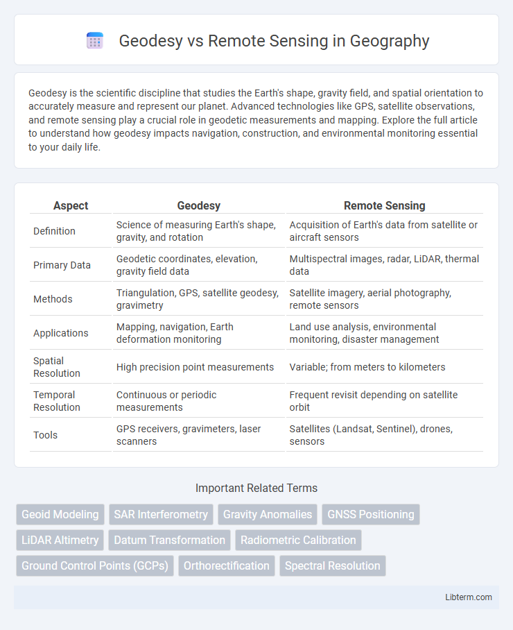
| Aspect | Geodesy | Remote Sensing |
|---|---|---|
| Definition | Science of measuring Earth's shape, gravity, and rotation | Acquisition of Earth's data from satellite or aircraft sensors |
| Primary Data | Geodetic coordinates, elevation, gravity field data | Multispectral images, radar, LiDAR, thermal data |
| Methods | Triangulation, GPS, satellite geodesy, gravimetry | Satellite imagery, aerial photography, remote sensors |
| Applications | Mapping, navigation, Earth deformation monitoring | Land use analysis, environmental monitoring, disaster management |
| Spatial Resolution | High precision point measurements | Variable; from meters to kilometers |
| Temporal Resolution | Continuous or periodic measurements | Frequent revisit depending on satellite orbit |
| Tools | GPS receivers, gravimeters, laser scanners | Satellites (Landsat, Sentinel), drones, sensors |
Introduction to Geodesy and Remote Sensing
Geodesy involves measuring and understanding Earth's geometric shape, orientation in space, and gravity field through precise techniques like GPS, satellite geodesy, and terrestrial surveys. Remote sensing encompasses acquiring information about Earth's surface using satellite or aerial sensors to detect and classify land cover, atmospheric conditions, and environmental changes. Both fields complement each other by integrating geodetic data with remotely sensed imagery for accurate spatial analysis and Earth observation.
Core Principles of Geodesy
Geodesy fundamentally involves measuring and understanding Earth's geometric shape, orientation in space, and gravitational field using techniques like GNSS, terrestrial surveying, and gravimetry. Core principles of geodesy emphasize precise positioning, establishing a global reference frame, and modeling the geoid to understand surface topography and Earth dynamics. In contrast, remote sensing captures Earth's surface information via satellite or aerial sensors, focusing on data acquisition rather than geometric and gravitational modeling.
Fundamental Concepts in Remote Sensing
Remote sensing involves acquiring information about Earth's surface without direct contact through sensors mounted on satellites or aircraft, relying on electromagnetic radiation to detect and measure features. It fundamentally encompasses data capture via passive or active sensors, image processing, and interpretation to analyze land cover, vegetation, and atmospheric conditions. Geodesy complements remote sensing by providing precise measurements of Earth's shape, gravitational field, and spatial referencing essential for accurate geospatial data integration and mapping.
Key Differences Between Geodesy and Remote Sensing
Geodesy primarily focuses on measuring and understanding Earth's geometric shape, gravitational field, and rotational dynamics using ground-based observations and satellite data. Remote sensing involves acquiring information about Earth's surface and atmosphere through satellite or aerial sensor technologies without direct contact. The key differences lie in geodesy's emphasis on precise Earth measurements and gravitational models, while remote sensing centers on capturing and analyzing electromagnetic data to monitor environmental and land-use changes.
Tools and Technologies in Geodesy
Geodesy utilizes tools such as Global Navigation Satellite Systems (GNSS), total stations, and leveling instruments to measure and map the Earth's geometric shape, orientation in space, and gravity field. Advanced technologies include satellite geodesy techniques like Very Long Baseline Interferometry (VLBI) and Gravity Recovery and Climate Experiment (GRACE) satellites, which enhance precision in Earth observation. These instruments and technologies provide critical data for geospatial referencing, tectonic movement analysis, and Earth's dynamic system monitoring, distinguishing geodesy from remote sensing methods that primarily capture surface imagery through aerial or satellite sensors.
Instrumentation and Sensors in Remote Sensing
Remote sensing relies on advanced instrumentation such as multispectral scanners, LiDAR sensors, and synthetic aperture radar (SAR) to capture detailed data from satellite and airborne platforms. These sensors detect and measure electromagnetic radiation across various wavelengths, enabling precise analysis of Earth's surface features and environmental changes. In contrast, geodesy primarily employs ground-based instruments like GNSS receivers, total stations, and gravimeters to measure Earth's geometric shape, gravitational field, and spatial orientation.
Applications of Geodesy in Modern Science
Geodesy plays a critical role in modern science by providing precise measurements of Earth's shape, gravity field, and spatial positioning, which are essential for satellite navigation systems, earthquake monitoring, and sea-level rise studies. Remote sensing complements geodesy by capturing large-scale environmental data through satellite imagery and aerial sensors, facilitating land-use mapping, climate change analysis, and natural disaster assessment. Together, these technologies enhance geospatial data accuracy and enable advanced Earth observation for scientific research and resource management.
Remote Sensing Applications Across Industries
Remote sensing technology plays a crucial role in various industries such as agriculture, forestry, environmental monitoring, and urban planning by enabling precise data collection through satellite and aerial imagery. It allows for real-time monitoring of crop health, deforestation rates, disaster impact assessment, and land-use changes, enhancing decision-making and resource management. In contrast to geodesy, which focuses on measuring Earth's shape and gravitational field, remote sensing provides dynamic spatial data essential for analyzing and predicting environmental and industrial processes.
Integration of Geodesy and Remote Sensing
The integration of geodesy and remote sensing enhances spatial data accuracy by combining precise Earth measurements with satellite imagery. Geodesy provides essential reference frames and ground control points, improving the calibration and validation of remote sensing products. This synergy supports advanced applications in environmental monitoring, geophysical studies, and infrastructure management.
Future Trends in Geospatial Science
Advancements in geospatial science are increasingly integrating geodesy and remote sensing through real-time satellite data and high-precision GNSS measurements, enhancing Earth surface monitoring accuracy. Emerging trends emphasize the fusion of multispectral remote sensing imagery with geodetic data to improve 3D terrain modeling and climate change analysis. Future developments target AI-driven data processing and cloud-based geospatial platforms to enable scalable, near-instantaneous analysis for disaster management and urban planning.
Geodesy Infographic