Alluvial deposits consist of sediments such as sand, silt, and clay transported and deposited by flowing water, typically in riverbeds and floodplains. These fertile soils play a crucial role in agriculture and landscape formation due to their nutrient-rich composition and excellent drainage properties. Explore the rest of the article to understand how alluvial deposits impact ecosystems and human activities.
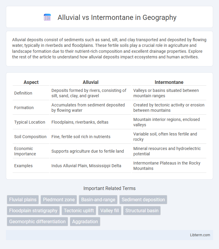
Table of Comparison
| Aspect | Alluvial | Intermontane |
|---|---|---|
| Definition | Deposits formed by rivers, consisting of silt, sand, clay, and gravel | Valleys or basins situated between mountain ranges |
| Formation | Accumulates from sediment deposited by flowing water | Created by tectonic activity or erosion between mountains |
| Typical Location | Floodplains, riverbanks, deltas | Mountain interior regions, enclosed valleys |
| Soil Composition | Fine, fertile soil rich in nutrients | Variable soil, often less fertile and rocky |
| Economic Importance | Supports agriculture due to fertile land | Mineral resources and hydroelectric potential |
| Examples | Indus Alluvial Plain, Mississippi Delta | Intermontane Plateaus in the Rocky Mountains |
Introduction to Alluvial and Intermontane Valleys
Alluvial valleys are low-lying areas formed by the deposition of sediments from rivers, characterized by fertile soil and often used for agriculture due to their rich nutrient content. Intermontane valleys lie between mountain ranges, shaped by tectonic activity or erosion, and typically exhibit a more rugged terrain with less fertile ground. These valleys differ significantly in their geological formation, soil composition, and suitability for human settlement and cultivation.
Defining Alluvial Valleys
Alluvial valleys are characterized by fertile soil deposits formed from sediment carried and laid down by rivers, creating flat, expansive floodplains ideal for agriculture. In contrast, intermontane valleys are located between mountain ranges and often feature narrow, rugged terrain shaped by tectonic activity and erosion rather than sedimentation. The distinct formation processes of alluvial valleys result in rich, nutrient-dense soils, making them critical for sustaining diverse ecosystems and human settlements.
Characteristics of Intermontane Valleys
Intermontane valleys are characterized by their formation between mountain ranges, often shaped by tectonic activity and erosion, creating steep and rugged terrain. These valleys typically feature narrow, elongated basins with limited sediment deposits compared to alluvial valleys, which accumulate extensive fertile soils from river sediments. The hydrographic network in intermontane valleys is generally less dense, with streams and rivers confined by the surrounding highlands, influencing local climate and biodiversity.
Formation Processes: Alluvial vs Intermontane
Alluvial formations arise from sediment deposition by flowing water, typically in river valleys, floodplains, and deltas, where materials such as sand, silt, and clay accumulate over time. Intermontane formations develop between mountain ranges, formed through tectonic uplifts and subsidence creating basins that collect sediments from surrounding highlands. The primary distinction lies in alluvial deposits being primarily water-driven sedimentary accumulations, whereas intermontane basins result from tectonic plate interactions and structural geology processes.
Geological Features and Soil Types
Alluvial regions are characterized by sediments deposited by rivers, consisting mainly of silt, sand, clay, and gravel, creating fertile soils ideal for agriculture. Intermontane areas lie between mountain ranges and feature complex geological formations including sedimentary basins, volcanic deposits, and metamorphic rocks, resulting in varied soil types often less nutrient-rich and more acidic than alluvial soils. The geological features of alluvial plains typically promote rich, well-drained soils, whereas intermontane zones exhibit diverse soil profiles influenced by tectonic activity and elevation gradients.
Climate Influences on Valley Development
Alluvial valleys develop predominantly in regions with ample water flow, where sediment from rivers shapes broad, fertile plains influenced by consistent precipitation and moderate temperatures. In contrast, intermontane valleys occur between mountain ranges and experience more variable climates, often with reduced precipitation and temperature extremes that limit sediment transport and influence the valley's narrow, rugged morphology. Climate factors such as rainfall patterns, temperature fluctuations, and seasonal snowmelt directly impact the erosion and deposition processes critical to the formation and evolution of both alluvial and intermontane valleys.
Ecological Diversity in Both Valley Types
Alluvial valleys, characterized by fertile soils deposited by rivers, support rich ecological diversity with thriving wetland ecosystems, diverse plant species, and abundant wildlife adapted to periodic flooding. Intermontane valleys, situated between mountain ranges, exhibit unique microclimates that foster specialized flora and fauna, often including endemic species adapted to drier, elevated conditions. The contrast in soil composition, moisture availability, and elevation between alluvial and intermontane valleys results in distinct biodiversity profiles crucial for regional ecological balance.
Human Settlement Patterns: Alluvial vs Intermontane
Alluvial regions, characterized by fertile soil deposited by rivers and frequent water availability, support dense human settlements and intensive agriculture due to easier access to resources and transportation. Intermontane areas, situated between mountain ranges, tend to have sparser populations because of rugged terrain, limited arable land, and more challenging infrastructure development. Human settlement patterns thus reflect the contrasting environmental conditions, with alluvial plains fostering urbanization and farming communities, while intermontane zones support smaller, often isolated settlements reliant on specialized subsistence strategies.
Economic Importance and Land Use
Alluvial plains, characterized by fertile soil deposited by rivers, are crucial for intensive agriculture, supporting high crop yields and sustaining local economies through farming and irrigation-based activities. Intermontane regions, situated between mountain ranges, often feature mineral resources and diverse ecosystems, enabling mining, forestry, and limited agriculture adapted to varied terrains and climates. Economic importance in alluvial areas centers on agro-based industries and settlement density, whereas intermontane zones contribute through resource extraction and niche agricultural practices, influencing land use planning and regional development strategies.
Key Differences and Conclusion
Alluvial plains are flat, fertile lands formed by sediment deposited over time by rivers, often characterized by rich soil ideal for agriculture, whereas intermontane regions are valleys or basins situated between mountain ranges, typically featuring more rugged terrain and diverse ecosystems. The key difference lies in their formation processes: alluvial plains result from sedimentation in river floodplains, while intermontane areas are shaped by tectonic activity and erosion between mountains. Understanding these distinctions highlights the influence of geological and hydrological factors on landscape development and land use potential.
Alluvial Infographic