Map projections transform the earth's three-dimensional surface onto a two-dimensional plane, balancing distortions in area, shape, distance, and direction. Choosing the right projection depends on your specific geographic needs, whether for navigation, education, or spatial analysis. Explore the rest of the article to understand various map projections and how to select the best one for your project.
Table of Comparison
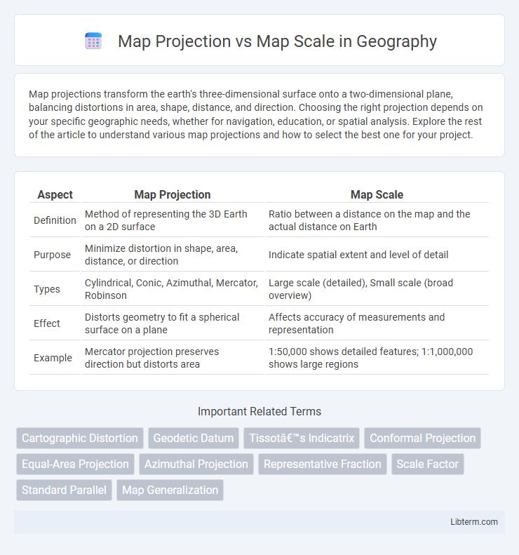
| Aspect | Map Projection | Map Scale |
|---|---|---|
| Definition | Method of representing the 3D Earth on a 2D surface | Ratio between a distance on the map and the actual distance on Earth |
| Purpose | Minimize distortion in shape, area, distance, or direction | Indicate spatial extent and level of detail |
| Types | Cylindrical, Conic, Azimuthal, Mercator, Robinson | Large scale (detailed), Small scale (broad overview) |
| Effect | Distorts geometry to fit a spherical surface on a plane | Affects accuracy of measurements and representation |
| Example | Mercator projection preserves direction but distorts area | 1:50,000 shows detailed features; 1:1,000,000 shows large regions |
Introduction to Map Projections and Map Scales
Map projections are methods used to represent the curved surface of the Earth on a flat map, involving different techniques to preserve properties such as area, shape, distance, or direction. Map scale indicates the relationship between a distance on the map and the corresponding distance on the ground, usually expressed as a ratio or fraction (e.g., 1:50,000). Understanding the distinctions between projection distortions and scale variations is essential for accurate spatial analysis and effective cartographic representation.
What is a Map Projection?
A map projection is a systematic transformation of the Earth's curved surface onto a flat plane, enabling the creation of two-dimensional maps. It involves mathematical formulas that convert geographic coordinates (latitude and longitude) into planar coordinates, balancing distortions in area, shape, distance, or direction depending on the projection type. Common projections include Mercator, Robinson, and Lambert Conformal Conic, each optimized for specific mapping purposes and regions.
Common Types of Map Projections
Common types of map projections include Mercator, Robinson, and Lambert Conformal Conic, each designed to represent the Earth's curved surface on a flat map with varying degrees of distortion. Mercator projection preserves direction, making it ideal for navigation, while Robinson balances size and shape for visually appealing world maps. The choice of projection affects how scale is represented, influencing the accuracy of distance and area measurements on the map.
Understanding Map Scale
Map scale represents the ratio between distances on a map and the actual distances on the Earth's surface, crucial for accurately interpreting geographical information. Understanding map scale involves recognizing different types such as verbal scale, graphic scale, and representative fraction, each providing essential tools for measuring real-world distances. Accurate use of map scale enables effective decision-making in navigation, urban planning, and resource management.
Types of Map Scales Explained
Map scales are categorized into three main types: verbal, graphic, and representative fraction (RF) scales, each serving a unique function in spatial representation. Verbal scales describe the ratio of map distance to ground distance using words, such as "one inch equals one mile," while graphic scales display a bar line marked with ground distances that can be physically measured on the map. Representative fraction scales express the scale as a ratio or fraction, like 1:50,000, indicating one unit on the map equals 50,000 units on the ground, and are vital for precise calculations and understanding the extent of map features.
Key Differences Between Map Projection and Map Scale
Map projection involves transforming the three-dimensional surface of the Earth onto a two-dimensional map, affecting the representation of area, shape, distance, and direction. Map scale refers to the ratio between a distance on the map and the corresponding distance on the ground, determining the level of detail and extent covered by the map. While map projection addresses spatial distortion and geometric representation, map scale emphasizes measurement and the proportionate relation between map features and real-world distances.
Impacts of Map Projection on Spatial Accuracy
Map projection significantly impacts spatial accuracy by distorting areas, shapes, distances, or directions depending on the chosen method, such as Mercator or Robinson projections. Each projection alters the geographic representation, causing variations in scale that affect measurements and spatial analysis. Accurate spatial data interpretation requires selecting a projection that minimizes distortion for the intended geographic region and purpose.
How Map Scale Influences Map Detail
Map scale directly impacts the level of detail displayed on a map, with larger scales (e.g., 1:10,000) providing more detailed and precise representations of geographic features than smaller scales (e.g., 1:1,000,000). Large-scale maps enable accurate depiction of individual buildings, roads, and landforms, critical for urban planning and detailed navigation. Conversely, small-scale maps prioritize broader geographic context, sacrificing fine details to cover larger areas efficiently, influencing how users interpret spatial relationships and geographic data.
Choosing the Right Projection and Scale for Your Map
Selecting the right map projection and scale is crucial for accurate spatial representation and effective data communication. Projections like Mercator preserve direction but distort area, suitable for navigation, while Equal-Area projections maintain area accuracy, ideal for thematic mapping. Choosing an appropriate scale depends on the map's purpose, balancing detail and coverage; large-scale maps provide detailed views for local analyses, whereas small-scale maps offer broader geographic context.
Conclusion: Balancing Projection and Scale in Cartography
Balancing map projection and scale is crucial for accurate cartographic representation, as each element influences spatial distortion and detail. Choosing the appropriate projection minimizes shape, area, distance, or direction errors, while selecting the correct scale ensures the map's usability for its intended purpose. Effective cartography requires integrating projection and scale decisions to optimize geographic accuracy and readability.
Map Projection Infographic