The Mollweide projection is a pseudocylindrical map projection used primarily for representing global data with equal-area properties, preserving the proportional sizes of landmasses and oceans. This projection distorts shapes but allows for accurate area comparisons across the entire map, making it invaluable for analyzing global distributions such as climate zones or demographic data. Explore the rest of this article to discover how the Mollweide projection can enhance your geographic visualizations.
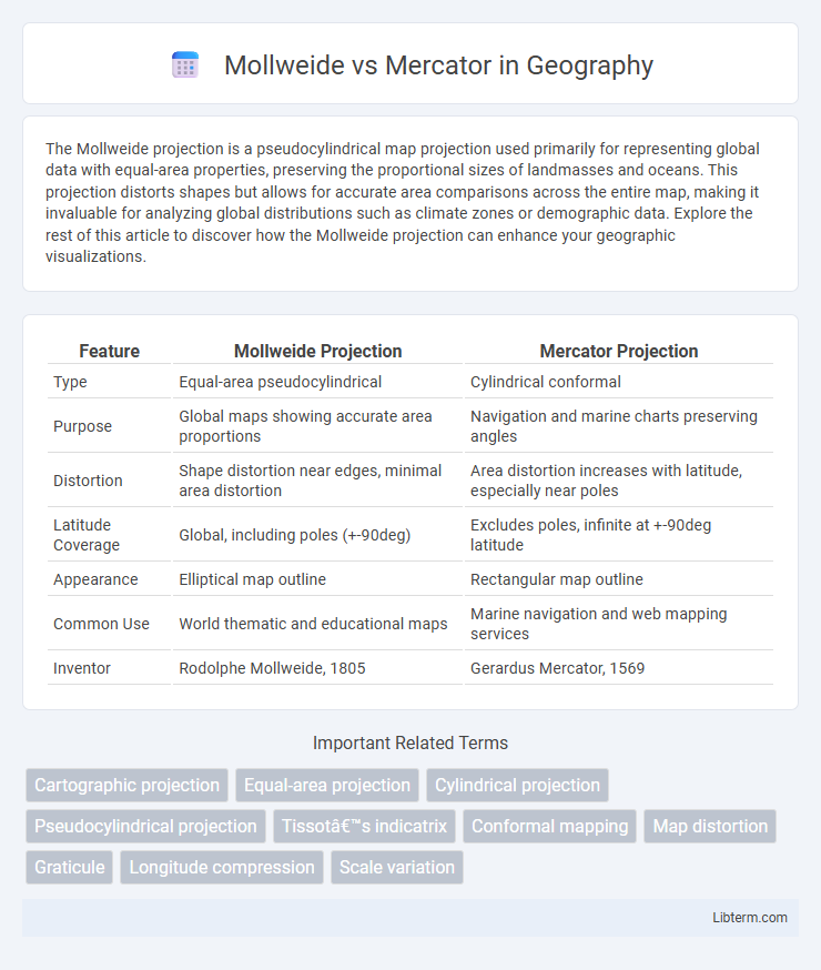
Table of Comparison
| Feature | Mollweide Projection | Mercator Projection |
|---|---|---|
| Type | Equal-area pseudocylindrical | Cylindrical conformal |
| Purpose | Global maps showing accurate area proportions | Navigation and marine charts preserving angles |
| Distortion | Shape distortion near edges, minimal area distortion | Area distortion increases with latitude, especially near poles |
| Latitude Coverage | Global, including poles (+-90deg) | Excludes poles, infinite at +-90deg latitude |
| Appearance | Elliptical map outline | Rectangular map outline |
| Common Use | World thematic and educational maps | Marine navigation and web mapping services |
| Inventor | Rodolphe Mollweide, 1805 | Gerardus Mercator, 1569 |
Introduction to Map Projections
Mollweide and Mercator are two distinct map projections used to represent the Earth's surface. Mollweide projection is an equal-area projection that accurately preserves area relationships, making it ideal for thematic and global distribution maps. Mercator projection, designed for navigation, preserves angles and shapes but distorts area, especially near the poles, resulting in enlarged landmasses at high latitudes.
Overview of Mollweide Projection
The Mollweide projection is an equal-area map representation designed to accurately depict global distributions by preserving area proportions, making it particularly valuable for thematic and climate maps. Unlike the Mercator projection, which distorts size near the poles, the Mollweide offers a more balanced view of landmasses, especially in high-latitude regions. Its elliptical shape and mathematical transformation minimize area distortion, enhancing the visualization of spatial phenomena across the entire globe.
Overview of Mercator Projection
The Mercator projection, developed by Gerardus Mercator in 1569, is a cylindrical map projection widely used for navigation due to its ability to represent lines of constant compass bearing as straight segments. It distorts size, particularly near the poles, where landmasses appear disproportionately large compared to equatorial regions. This projection is favored for maritime charts but less suitable for representing global spatial relationships accurately, unlike equal-area projections such as Mollweide.
Historical Context and Development
The Mollweide projection, developed by Karl Mollweide in 1805, was designed to display global distributions with accurate area representation, making it valuable for thematic and statistical maps. In contrast, the Mercator projection, created by Gerardus Mercator in 1569, was originally intended for navigational purposes, preserving angles and directions but distorting size, especially near the poles. The historical development of these projections reflects evolving needs in cartography, from practical navigation to accurate data visualization.
Key Differences in Design
The Mollweide projection is an equal-area map that preserves area proportions, making it ideal for thematic and global distribution maps, while the Mercator projection is conformal, preserving angles and shapes locally but greatly distorting area, especially near the poles. Mollweide features an elliptical shape that compresses the poles into straight lines, efficiently displaying the entire Earth on an oval grid, whereas Mercator uses a cylindrical grid expanding infinitely at the poles, resulting in exaggerated landmasses like Greenland and Antarctica. These design differences define their primary uses: Mollweide is preferred for accurate spatial comparisons, while Mercator excels for navigation due to maintaining accurate compass bearings.
Geometric Distortions Compared
The Mollweide projection minimizes area distortion by representing the entire globe as an ellipse, preserving relative sizes but significantly distorting shapes near the edges. The Mercator projection maintains accurate angles and shapes for navigation but greatly inflates areas near the poles, causing extreme size distortions for high-latitude regions like Greenland. Geographically, Mollweide is preferred for global thematic maps emphasizing spatial area accuracy, while Mercator is optimal for marine navigation due to its conformal properties.
Applications and Use Cases
The Mollweide projection excels in representing global data distributions with accurate area proportions, making it ideal for thematic maps such as climate, population density, and land use. The Mercator projection is widely used for navigation and maritime charts due to its ability to represent rhumb lines as straight lines, simplifying course plotting despite distorting area near the poles. Cartographers select Mollweide for spatial analysis requiring equal-area representation, while Mercator remains preferred for route planning and interactive web maps emphasizing direction over area accuracy.
Advantages of Mollweide vs Mercator
The Mollweide projection offers significant advantages over the Mercator projection by providing an equal-area representation, which preserves the relative size of landmasses, making it ideal for thematic and distribution maps. Unlike the Mercator, which distorts size especially near the poles, the Mollweide projection accurately displays spatial relationships across the entire globe, enhancing analyses in geography and environmental science. This feature ensures users can compare regions more realistically without the exaggerated scale that the Mercator introduces at higher latitudes.
Limitations and Criticisms
The Mollweide projection distorts shape and direction, especially near the edges, making it less suitable for navigation despite its accurate area representation. The Mercator projection, while preserving angles and shapes, significantly exaggerates sizes near the poles, leading to misleading interpretations of geographic scale. Both projections face limitations, with Mollweide criticized for its distortion of polar regions and Mercator for its Eurocentric emphasis and size exaggeration of high-latitude countries.
Choosing the Right Projection for Your Needs
The Mollweide projection preserves area, making it ideal for thematic and global data distribution maps, while the Mercator projection maintains shape and direction, beneficial for navigation and marine charts. Choosing between Mollweide and Mercator depends on whether accurate area representation or angular conformity is more critical for your project. Consider the map's purpose: use Mollweide for proportional data visualization and Mercator for route plotting and directional accuracy.
Mollweide Infographic