An oxbow lake forms when a river meander is cut off from the main channel, creating a crescent-shaped body of water. This natural process results from erosion and deposition, which gradually isolates the bend from the flow of the river. Discover how oxbow lakes influence local ecosystems and their role in shaping the landscape by reading the rest of the article.
Table of Comparison
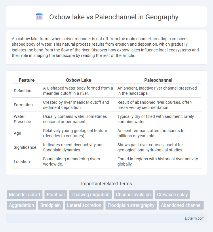
| Feature | Oxbow Lake | Paleochannel |
|---|---|---|
| Definition | A U-shaped water body formed from a meander cutoff in a river. | An ancient, inactive river channel preserved in the landscape. |
| Formation | Created by river meander cutoff and sediment deposition. | Result of abandoned river courses, often preserved by sedimentation. |
| Water Presence | Usually contains water, sometimes seasonal or permanent. | Typically dry or filled with sediment; rarely contains water. |
| Age | Relatively young geological feature (decades to centuries). | Ancient remnant, often thousands to millions of years old. |
| Significance | Indicates recent river activity and floodplain dynamics. | Shows past river courses, useful for geological and hydrological studies. |
| Location | Found along meandering rivers worldwide. | Found in regions with historical river activity globally. |
Introduction to Oxbow Lakes and Paleochannels
Oxbow lakes form when a river creates a meander, which is eventually cut off from the main channel, resulting in a crescent-shaped water body. Paleochannels are ancient, inactive river channels that have been filled or buried by sediment over time, preserving the course of previous water flow. Both features provide insights into historical river dynamics and landscape evolution.
Formation Processes: Oxbow Lakes vs Paleochannels
Oxbow lakes form through the meandering and cutoff processes of river bends, where flowing water erodes banks and deposits sediment, eventually isolating a curved water body from the main channel. Paleochannels are ancient river or stream channels that have been filled or buried by sediment over time due to climatic or geological changes, representing former drainage pathways no longer active. The key distinction lies in oxbow lakes being current water bodies shaped by fluvial dynamics, while paleochannels signify historical river courses preserved in the geological record.
Geographical Distribution and Occurrence
Oxbow lakes predominantly form in meandering river systems across floodplains, commonly found in regions with low gradients such as the Mississippi River Basin in North America and the Brahmaputra River in South Asia. Paleochannels represent ancient, inactive river channels preserved in arid and semi-arid landscapes like the Sahara Desert and parts of Australia, often identified through satellite imagery and geological surveys. The geographical distribution of oxbow lakes is dynamic and recent, whereas paleochannels mark historical fluvial activity, reflecting long-term climatic and tectonic changes.
Morphological Differences
Oxbow lakes are crescent-shaped water bodies formed by the cut-off meanders of active rivers, characterized by their distinct curved morphology and isolated water flow. Paleochannels are ancient, inactive river channels filled with sediments, often displaying a linear or sinuous pattern that reflects previous fluvial paths but lacks active water connection. Morphologically, oxbow lakes exhibit well-defined curved boundaries with stagnant water, while paleochannels appear as buried or surface depressions with sediment infill and do not retain water unless recharged.
Hydrological Characteristics
Oxbow lakes are crescent-shaped water bodies formed by the cutoff of meanders in active river channels, exhibiting stagnant water and seasonal fluctuations influenced by precipitation and groundwater flow. Paleochannels are ancient, abandoned river channels often filled with sediments, showing minimal current hydrological activity but serving as significant groundwater reservoirs or pathways for subsurface flow. The hydrological distinctions highlight oxbow lakes as dynamic surface water features contrasted with paleochannels' role in influencing subsurface water movement and aquifer recharge.
Ecological Significance and Biodiversity
Oxbow lakes and paleochannels both serve as vital ecological habitats supporting diverse aquatic and riparian species. Oxbow lakes, formed by river meandering, create isolated water bodies that foster high biodiversity, including specialized fish, amphibians, and bird species due to their relatively stable water conditions. Paleochannels, representing ancient river courses, contribute to groundwater recharge and provide unique wetland ecosystems that sustain diverse plant communities and act as critical refuges for wildlife during dry periods.
Geological and Historical Insights
Oxbow lakes form through the natural meandering and cutoff of river bends, creating crescent-shaped water bodies that provide vital records of fluvial dynamics and sediment deposition in geological history. Paleochannels represent ancient, buried river channels that reveal past hydrological networks, climatic conditions, and landscape evolution, often identified through remote sensing and subsurface geophysical techniques. Both features offer critical insights into Quaternary geology, sedimentology, and environmental change, aiding in reconstructing paleoenvironments and understanding sedimentary basin development.
Human Impact and Anthropogenic Changes
Oxbow lakes, formed from the cutoff meanders of rivers, are often influenced by urban development and agriculture, which can alter water quality and sedimentation patterns through pollution and land use changes. Paleochannels, ancient riverbeds preserved underground or as surface depressions, are affected by groundwater extraction, mining, and infrastructure projects, leading to modifications in hydrological regimes and landscape stability. Both features reflect significant anthropogenic impacts that reshape fluvial dynamics and ecosystem functions in their respective environments.
Research and Mapping Techniques
Oxbow lakes and paleochannels are studied using advanced geospatial technologies such as remote sensing, aerial photography, and GIS mapping to analyze their morphologies and hydrological dynamics. Researchers employ sediment analysis, ground-penetrating radar, and LiDAR to reconstruct historical river courses and understand fluvial processes influencing oxbow lake formation and paleochannel evolution. High-resolution satellite imagery and hydrological modeling further enhance the precision of mapping and monitoring these geomorphological features in diverse environmental contexts.
Importance in Environmental Studies
Oxbow lakes and paleochannels serve as critical indicators in environmental studies, revealing past and present fluvial dynamics and sedimentary processes. Oxbow lakes, formed from abandoned meanders, support diverse ecosystems and act as natural water reservoirs that enhance biodiversity and water quality. Paleochannels provide valuable information on historical river courses and climatic changes, aiding in groundwater exploration, land use planning, and understanding sediment deposition patterns.
Oxbow lake Infographic