River terraces are elevated landforms formed by the natural erosion and deposition processes of a river, marking previous riverbed levels. These terraces provide valuable insights into geological history, climate changes, and river dynamics over time. Explore the rest of the article to discover how river terraces impact your understanding of landscape evolution and environmental change.
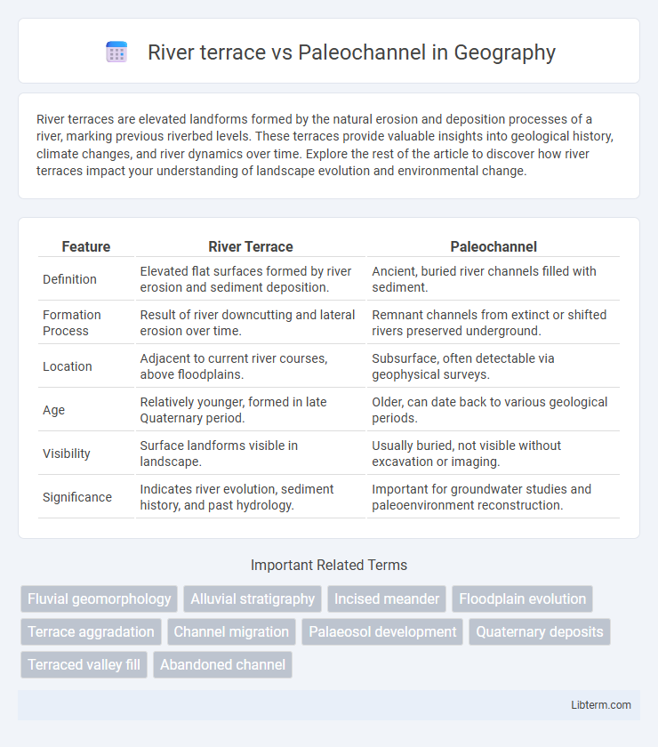
Table of Comparison
| Feature | River Terrace | Paleochannel |
|---|---|---|
| Definition | Elevated flat surfaces formed by river erosion and sediment deposition. | Ancient, buried river channels filled with sediment. |
| Formation Process | Result of river downcutting and lateral erosion over time. | Remnant channels from extinct or shifted rivers preserved underground. |
| Location | Adjacent to current river courses, above floodplains. | Subsurface, often detectable via geophysical surveys. |
| Age | Relatively younger, formed in late Quaternary period. | Older, can date back to various geological periods. |
| Visibility | Surface landforms visible in landscape. | Usually buried, not visible without excavation or imaging. |
| Significance | Indicates river evolution, sediment history, and past hydrology. | Important for groundwater studies and paleoenvironment reconstruction. |
Introduction to River Terraces and Paleochannels
River terraces are step-like landforms formed by the lateral and vertical erosion of river valleys, representing previous riverbed levels that indicate past fluvial processes and climatic changes. Paleochannels are ancient, inactive river channels preserved in the geological record, often filled with sediments that provide crucial information about past hydrological conditions and landscape evolution. Both features are essential in geomorphology and sedimentology for reconstructing paleoenvironmental histories and understanding sediment deposition patterns.
Defining River Terraces
River terraces are elevated landforms composed of fluvial deposits that represent former riverbed surfaces, formed by the downcutting of a river into its floodplain. Paleochannels are ancient, inactive river channels buried beneath newer sediments, often preserving past drainage patterns. Unlike paleochannels, river terraces provide crucial evidence of river incision and landscape evolution through sequential sediment deposition.
Understanding Paleochannels
Paleochannels are ancient, inactive river or stream channels filled with sediments, providing critical insights into past hydrological conditions and landscape evolution. Unlike river terraces, which represent former floodplain levels adjacent to active rivers, paleochannels often indicate buried, preserved pathways of prehistoric waterways. Understanding paleochannels supports groundwater exploration, archaeological studies, and reconstructing paleoenvironments for geological and environmental research.
Formation Processes: River Terrace vs Paleochannel
River terraces form through the episodic cutting and filling of river valleys, where changes in water flow or base level cause the river to abandon former floodplains, leaving elevated flat surfaces. Paleochannels develop as former river channels that have been filled or buried by sediment after the river changed course, preserving the original channel geometry beneath younger deposits. Both features reveal key insights into past fluvial dynamics but differ in formation: terraces result from vertical incision and abandonment, while paleochannels represent preserved older channels beneath alluvial layers.
Geological Significance and Differences
River terraces represent former floodplain levels formed by the vertical incision of rivers, indicating changes in water flow, sediment supply, and climatic conditions over geological timeframes. Paleochannels are ancient, buried river channels preserved in the subsurface, providing critical insights into past fluvial environments, sedimentation processes, and paleohydrology. The primary geological difference lies in river terraces being extant landforms visible on the landscape, while paleochannels are subsurface features detectable through geophysical methods or drilling, both essential for reconstructing landscape evolution and sedimentary history.
Identification Methods and Field Recognition
River terraces are identified through topographic mapping, geomorphological surveys, and sediment analysis, often characterized by flat, step-like landforms parallel to current river valleys, with well-sorted, stratified alluvial deposits. Paleochannels are recognized using remote sensing techniques such as satellite imagery or ground-penetrating radar, revealing buried or inactive ancient river courses with distinct sedimentary structures, often detected by differences in soil moisture or vegetation patterns. Field recognition of river terraces involves observing elevation above the active floodplain and terrace surface morphology, whereas paleochannels are confirmed through subsurface sediment sampling and stratigraphic correlation with past hydrological conditions.
Importance in Fluvial Geomorphology
River terraces serve as crucial indicators of past river dynamics, marking former floodplain levels and aiding in the reconstruction of fluvial history and climate change impacts. Paleochannels provide essential insights into ancient river pathways, sediment transport processes, and landscape evolution, enhancing the understanding of sedimentology and hydrogeology. Both features are fundamental in fluvial geomorphology for interpreting morphological changes, sedimentary environments, and guiding flood risk assessment and land use planning.
Environmental and Archaeological Implications
River terraces represent former floodplain surfaces shaped by fluvial processes and are key to reconstructing paleoclimatic conditions, while paleochannels, as buried ancient river courses, provide critical records of past hydrology and sediment transport. Archaeologically, river terraces often preserve artifacts in stratified contexts ideal for dating human activities, whereas paleochannels can reveal submerged cultural deposits, enhancing understanding of early human-environment interactions. Environmental implications include river terraces indicating landscape stability phases, while paleochannels inform groundwater distribution and resource management strategies.
Case Studies Comparing River Terraces and Paleochannels
Case studies comparing river terraces and paleochannels reveal distinct sedimentary characteristics and formation processes, with river terraces typically representing former floodplain levels shaped by fluvial incision during climatic changes. Paleochannels, identified through geophysical surveys and borehole data, exhibit ancient abandoned river paths often filled with alluvial deposits, providing insights into paleoenvironmental conditions and groundwater reservoirs. Research in regions like the Indo-Gangetic Plain and Australian outback highlights their significance for hydrogeology, archaeological site preservation, and landscape evolution analysis.
Conclusion: Key Differences and Research Perspectives
River terraces are elevated landforms composed of alluvial deposits that mark previous riverbed levels, while paleochannels represent ancient, buried river courses often identified through subsurface investigations. Key differences lie in their formation processes, stratigraphic contexts, and hydrological significance, with terraces indicating episodic river downcutting and paleochannels reflecting preserved paleohydrological pathways. Current research emphasizes integrating geomorphology, sedimentology, and geophysical techniques to better understand fluvial evolution, groundwater resources, and paleoclimate reconstructions.
River terrace Infographic