Paleoclimatology studies Earth's past climates through data from tree rings, ice cores, and sediment layers to understand natural climate variability over millennia. This field helps reveal how ancient climate shifts influenced ecosystems and human civilizations. Discover more about the tools and findings that shape our knowledge of Earth's changing climate in the full article.
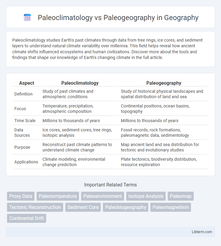
Table of Comparison
| Aspect | Paleoclimatology | Paleogeography |
|---|---|---|
| Definition | Study of past climates and atmospheric conditions | Study of historical physical landscapes and spatial distribution of land and sea |
| Focus | Temperature, precipitation, atmospheric composition | Continental positions, ocean basins, topography |
| Time Scale | Millions to thousands of years | Millions to thousands of years |
| Data Sources | Ice cores, sediment cores, tree rings, isotopic analysis | Fossil records, rock formations, paleomagnetic data, sedimentology |
| Purpose | Reconstruct past climate patterns to understand climate change | Map ancient land and sea distribution for tectonic and evolutionary studies |
| Applications | Climate modeling, environmental change prediction | Plate tectonics, biodiversity distribution, resource exploration |
Introduction to Paleoclimatology and Paleogeography
Paleoclimatology studies Earth's past climates by analyzing proxy data such as ice cores, tree rings, and sediment layers to understand climate patterns and changes over geological time. Paleogeography reconstructs past physical landscapes and continental configurations through fossil records, rock formations, and plate tectonic movements to reveal Earth's historical geographic evolution. Together, these fields provide critical insights into how climatic and geographic shifts have shaped Earth's environment and ecosystems across millions of years.
Defining Paleoclimatology: Study of Ancient Climates
Paleoclimatology examines ancient climates through data sources like ice cores, tree rings, and sediment deposits to reconstruct Earth's climate history over millions of years. It provides insights into temperature variations, atmospheric composition, and climate events such as ice ages and warming periods. Paleogeography, by contrast, maps the historical distribution of continents, oceans, and ecosystems, emphasizing Earth's physical layout rather than climatic conditions.
Understanding Paleogeography: Mapping Ancient Landscapes
Paleogeography reconstructs ancient landscapes by analyzing sedimentary deposits, fossil distributions, and tectonic plate movements to map Earth's surface changes over geological time. Understanding paleogeography reveals the arrangement of continents, oceans, and mountain ranges, providing critical context for interpreting paleoclimatic data and Earth's environmental evolution. Techniques such as paleomagnetic studies and stratigraphic correlation enhance the accuracy of these reconstructions, aiding in the study of ancient ecosystems and climate patterns.
Methods and Tools in Paleoclimatology
Paleoclimatology primarily employs methods such as ice core analysis, sediment core sampling, and dendrochronology to reconstruct past climate conditions by examining proxies like isotopic ratios, pollen records, and trapped gas concentrations. Tools including mass spectrometers, radiometric dating techniques, and climate models facilitate precise temporal and environmental reconstructions. These methodologies enable the quantification of temperature, atmospheric composition, and precipitation patterns critical for understanding Earth's climate history, distinguishing paleoclimatology's focus from paleogeography's emphasis on spatial landscape changes.
Techniques Used in Paleogeographic Reconstructions
Paleogeographic reconstructions primarily utilize sedimentological analysis, fossil assemblages, and stratigraphic correlation to map ancient landforms and environments. Geophysical methods such as seismic reflection and magnetic anomaly detection provide subsurface data critical for reconstructing past tectonic settings. Integration of satellite imagery and Geographic Information Systems (GIS) enhances spatial accuracy and visualization of paleogeographic changes through geologic time.
Key Differences Between Paleoclimatology and Paleogeography
Paleoclimatology studies ancient climate patterns using proxies such as ice cores, tree rings, and sediment layers to reconstruct past temperature, precipitation, and atmospheric conditions. Paleogeography focuses on the historical distribution of continents, oceans, and landscapes by analyzing geological formations, fossil records, and tectonic shifts. The key difference lies in paleoclimatology's emphasis on climate dynamics and atmospheric changes, whereas paleogeography centers on physical Earth's surface changes and spatial configurations over geologic time.
Interconnections: How Climate and Geography Influence Each Other
Paleoclimatology examines ancient climate patterns by analyzing ice cores, sediment layers, and fossil records to understand atmospheric conditions over geological time, while paleogeography reconstructs past landforms, ocean basins, and tectonic shifts that shaped Earth's surface. The interconnection between paleoclimatology and paleogeography is evident as changing continental positions alter ocean currents and atmospheric circulation, which in turn influence climate variability and ecosystem distribution. For example, the formation of mountain ranges affects precipitation patterns and glaciation, demonstrating how geographic evolution drives climatic shifts and feedback mechanisms in Earth's history.
Case Studies: Fossil Evidence in Climate and Geographic Reconstructions
Paleoclimatology uses fossil evidence such as pollen, tree rings, and ice cores to reconstruct Earth's past climates, providing insights into temperature fluctuations and atmospheric composition over millions of years. Paleogeography relies on fossil distributions, including marine organisms and terrestrial plants, to map ancient landmasses, ocean basins, and continental positions during different geologic periods. Case studies like the examination of foraminifera assemblages reveal both climatic conditions and shifting paleogeographic boundaries, illustrating the interconnectedness of past climate and geographic reconstructions.
Applications in Modern Science and Climate Prediction
Paleoclimatology provides critical data on past climate variations through ice cores, tree rings, and sediment analysis, enhancing climate prediction models and informing modern environmental policy. Paleogeography reconstructs ancient landforms and continental positions, aiding in understanding plate tectonics, ocean circulation, and habitat shifts that influence current climate systems. Together, these fields enable accurate simulation of Earth's past climates, improving projections of future climate change and guiding sustainable resource management.
Future Directions in Paleoclimatology and Paleogeography Research
Emerging technologies in paleoclimatology leverage high-resolution climate proxies and advanced climate modeling to improve reconstructions of past atmospheric conditions, enabling more accurate predictions of future climate change. Paleogeography integrates increasingly detailed geospatial data and tectonic plate reconstructions to refine our understanding of ancient landmass configurations and their influence on Earth's climate systems. Interdisciplinary approaches combining paleoclimatic data with paleogeographic mapping are expected to drive breakthroughs in deciphering Earth's environmental history and forecasting long-term ecological shifts.
Paleoclimatology Infographic