Field surveying involves precise measurements and data collection to map and analyze land features for construction, engineering, and land development projects. Utilizing advanced tools like GPS, total stations, and drones ensures accuracy and efficiency in capturing spatial information. Explore the rest of the article to understand how field surveying can support your projects with reliable and detailed terrain data.
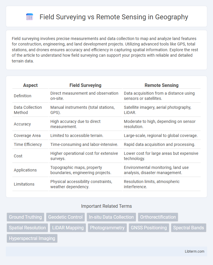
Table of Comparison
| Aspect | Field Surveying | Remote Sensing |
|---|---|---|
| Definition | Direct measurement and observation on-site. | Data acquisition from a distance using sensors or satellites. |
| Data Collection Method | Manual instruments (total stations, GPS). | Satellite imagery, aerial photography, LiDAR. |
| Accuracy | High accuracy due to direct measurement. | Moderate to high, depending on sensor resolution. |
| Coverage Area | Limited to accessible terrain. | Large-scale, regional to global coverage. |
| Time Efficiency | Time-consuming and labor-intensive. | Rapid data acquisition and processing. |
| Cost | Higher operational cost for extensive surveys. | Lower cost for large areas but expensive technology. |
| Applications | Topographic maps, property boundaries, engineering projects. | Environmental monitoring, land use analysis, disaster management. |
| Limitations | Physical accessibility constraints, weather dependency. | Resolution limits, atmospheric interference. |
Introduction to Field Surveying and Remote Sensing
Field surveying involves direct measurement and observation of physical environments using tools like total stations, GPS, and levels, providing highly accurate and localized spatial data. Remote sensing uses satellite or aerial sensors to capture data over large areas, enabling the analysis of landforms, vegetation, and human activities without physical contact. Both methods offer complementary data sets essential for geographic information systems (GIS) and environmental monitoring.
Definition and Key Concepts
Field surveying involves the direct collection of geospatial data using traditional tools like total stations, GPS devices, and measuring tapes to capture precise ground measurements and topographic details. Remote sensing utilizes satellite or aerial sensor technologies to acquire information about Earth's surface without physical contact, relying on electromagnetic spectrum data for mapping and environmental monitoring. Both methods are essential in geospatial analysis, with field surveying offering high accuracy and remote sensing providing broad-area coverage and temporal data.
Historical Evolution of Surveying Methods
Field surveying originated thousands of years ago with basic tools like chains and compasses, evolving significantly through the introduction of the theodolite and total station in the 19th and 20th centuries. Remote sensing emerged in the mid-20th century with satellite imagery and aerial photography, revolutionizing data acquisition by enabling large-scale environmental monitoring and geographic mapping without direct contact. The integration of GPS technology further transformed both methods, enhancing spatial accuracy and enabling real-time data collection across diverse terrains.
Tools and Technologies Used
Field surveying relies on traditional tools such as total stations, GPS receivers, theodolites, and leveling instruments to collect precise ground measurements. Remote sensing utilizes advanced technologies like multispectral and hyperspectral satellite imagery, LiDAR sensors, UAV (drone) platforms, and radar systems to capture extensive spatial data from a distance. Integration of Geographic Information Systems (GIS) enhances the analysis and visualization of data obtained from both field surveys and remote sensing methods.
Accuracy and Precision Comparison
Field surveying achieves high accuracy and precision through direct measurements using tools like total stations and GPS receivers, minimizing errors caused by environmental factors. Remote sensing offers extensive spatial coverage but may experience reduced accuracy and precision due to atmospheric conditions, sensor resolution, and data processing algorithms. Combining field surveying with remote sensing data enhances overall measurement reliability by calibrating and validating sensor outputs.
Cost Analysis and Budget Considerations
Field surveying generally incurs higher labor costs and requires specialized equipment, leading to increased expenses for extensive or difficult terrains. Remote sensing reduces on-ground personnel needs and offers scalable data collection, often resulting in lower overall costs for large-area mapping and monitoring projects. Budget considerations must account for initial technology investment in remote sensing and potential data processing expenses versus the variable costs tied to field survey duration and accessibility challenges.
Applications in Various Industries
Field surveying provides precise, on-site measurements essential for construction, land development, and environmental monitoring, ensuring accurate topographic data and boundary delineation. Remote sensing employs satellite or aerial imagery to efficiently gather large-scale information for agriculture, forestry, urban planning, and disaster management, enabling real-time analysis of land use, crop health, and natural resource distribution. Integrating both methods enhances decision-making by combining detailed ground data with broad spatial coverage across diverse industrial applications.
Advantages and Limitations
Field surveying offers high accuracy and detailed ground-level data essential for precise measurements and land demarcation, but it is often time-consuming, labor-intensive, and limited by terrain accessibility. Remote sensing provides extensive spatial coverage, rapid data acquisition, and the ability to monitor large or inaccessible areas using aerial or satellite imagery, although it may suffer from limitations in resolution, atmospheric interference, and reduced accuracy for fine-scale features. Combining field surveying with remote sensing can optimize data quality and measurement efficiency in geospatial projects.
Integration of Field Surveying with Remote Sensing
Integrating field surveying with remote sensing enhances data accuracy by providing ground-truth validation for satellite imagery and aerial photographs, ensuring precise mapping and environmental monitoring. Field surveys offer detailed, on-site measurements that complement remote sensing's broad spatial coverage, enabling comprehensive analysis for land use planning, agriculture, and natural resource management. This synergy improves decision-making by combining high-resolution spatial data with contextual, real-world observations.
Future Trends in Surveying Technologies
Future trends in surveying technologies emphasize the integration of field surveying with advanced remote sensing methods, leveraging UAVs, LiDAR, and satellite imagery to enhance data accuracy and efficiency. The development of AI-driven data processing algorithms and real-time geospatial analytics is transforming traditional surveying workflows, enabling faster decision-making and predictive modeling. Increased adoption of BIM (Building Information Modeling) and IoT (Internet of Things) integration fosters smarter infrastructure monitoring and maintenance, pushing the boundaries of geospatial technology applications.
Field Surveying Infographic