Meridian represents a key element in geography and timekeeping, defining imaginary lines that run from the North to the South Pole and help establish time zones around the world. Understanding the role of meridians enhances your grasp of global navigation, mapping systems, and the coordination of international time standards. Explore the article to discover how meridians impact daily life and why they remain crucial in modern science.
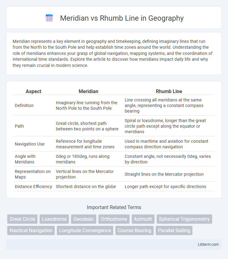
Table of Comparison
| Aspect | Meridian | Rhumb Line |
|---|---|---|
| Definition | Imaginary line running from the North Pole to the South Pole | Line crossing all meridians at the same angle, representing a constant compass bearing |
| Path | Great circle, shortest path between two points on a sphere | Spiral or loxodrome, longer than the great circle path except along the equator or meridians |
| Navigation Use | Reference for longitude measurement and time zones | Used in maritime and aviation for constant compass direction navigation |
| Angle with Meridians | 0deg or 180deg, runs along meridians | Constant angle, not necessarily 0deg, varies by direction |
| Representation on Maps | Vertical lines on the Mercator projection | Straight lines on the Mercator projection |
| Distance Efficiency | Shortest distance on the globe | Longer path except for specific directions |
Introduction to Meridian and Rhumb Line
Meridian lines, also known as lines of longitude, are imaginary lines running from the North Pole to the South Pole, used to measure geographic coordinates and establish time zones. Rhumb lines, or loxodromes, are paths crossing all meridians at a constant angle, representing a constant compass bearing often used in marine navigation. Understanding the distinction between meridians and rhumb lines is essential for accurate map reading and navigation.
Defining Meridian: Concept and Applications
A meridian is a great circle on the Earth's surface that runs from the North Pole to the South Pole, representing lines of constant longitude. It is essential in geographical coordinate systems for determining exact locations and time zones. Meridians are widely used in navigation, cartography, and global positioning systems (GPS) to measure longitudinal positions and support accurate mapping.
Understanding Rhumb Line: Meaning and Usage
A rhumb line, also known as a loxodrome, is a path crossing all meridians at a constant angle, maintaining a fixed compass direction. It is widely used in navigation for plotting courses on nautical charts because it simplifies steering by allowing a constant bearing. Unlike meridians, which converge at the poles, rhumb lines spiral towards the poles on a sphere, resulting in longer distances compared to the shortest great circle routes.
Key Differences Between Meridian and Rhumb Line
Meridians are great circles running from pole to pole, representing the shortest distance between two points on Earth's surface along a north-south direction. Rhumb lines maintain a constant compass bearing by crossing all meridians at the same angle, resulting in a spiral path on a globe rather than the shortest route. The key difference lies in navigation: meridians provide the shortest path but require continuous bearing changes, while rhumb lines allow simpler navigation with a fixed heading but longer travel distances.
Geometric Properties of Meridians
Meridians are great circles that run from the North to the South Pole, intersecting all parallels at right angles, which makes them geodesics on the Earth's ellipsoid. Unlike rhumb lines that maintain a constant compass bearing by crossing meridians at a constant angle, meridians have a varying azimuth except at the poles. The geometric property of meridians as convergence lines is crucial for accurate navigation and map projections, ensuring true north-south directionality across the Earth's surface.
Navigational Importance of Rhumb Lines
Rhumb lines, also known as loxodromes, maintain a constant compass bearing, making them crucial for straightforward navigation across long distances. Unlike meridians that converge at the poles, rhumb lines provide a practical route for sailors by enabling steady, predictable courses without frequent compass adjustments. This navigational importance simplifies chart plotting and ensures safer, more efficient maritime travel.
Meridian Routes in Global Navigation
Meridian routes, also known as great circle routes, follow the shortest path between two points on the Earth's surface by intersecting all meridians at right angles. These routes are crucial in global navigation for minimizing fuel consumption and travel time, especially over long distances. Unlike rhumb lines, which maintain a constant compass bearing but result in longer paths, meridian routes leverage the Earth's spherical geometry for efficient cross-continental and transoceanic travel.
Rhumb Line Paths on Different Map Projections
Rhumb line paths, representing constant compass bearings, appear as straight lines on Mercator projections, making navigation straightforward. On other map projections like the gnomonic or orthographic, rhumb lines curve, distorting their true course and complicating path plotting. Understanding these variations is crucial for accurate maritime and aeronautical navigation across diverse cartographic representations.
Practical Examples: When to Use Meridian vs Rhumb Line
Navigators use meridians for calculating shortest distances on spherical surfaces, especially during long-haul flights or sea voyages where great-circle routes minimize travel time and fuel consumption. Rhumb lines are preferred for marine navigation and aviation when maintaining a constant compass heading is critical, such as coastal piloting or crossing narrow straits. GPS and chart plotting software often assist in switching between meridian and rhumb line navigation based on the specific route requirements for accuracy and ease of steering.
Conclusion: Choosing the Right Path for Navigation
Meridians provide the shortest distance between two points by following a great circle route, essential for efficient long-distance navigation. Rhumb lines maintain a constant compass bearing, simplifying navigation despite covering a longer distance. Selecting the appropriate path depends on balancing accuracy needs and ease of steering, with meridians favored for precision and rhumb lines preferred for straightforward course maintenance.
Meridian Infographic