Topography shapes the physical landscape by detailing the natural and artificial features of an area, including mountains, valleys, and urban infrastructure. Accurate topographic data is essential for urban planning, environmental management, and outdoor activities, influencing how you navigate and interact with the environment. Explore the full article to understand how topography impacts various aspects of our world.
Table of Comparison
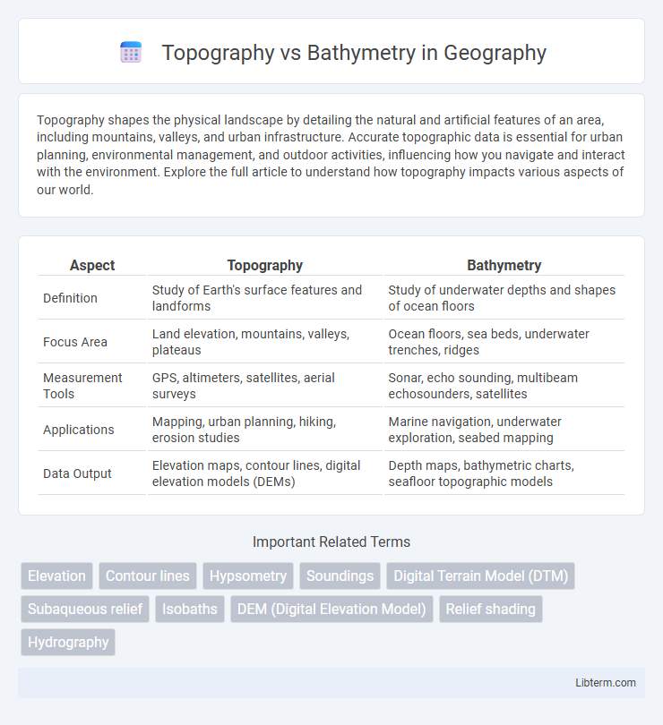
| Aspect | Topography | Bathymetry |
|---|---|---|
| Definition | Study of Earth's surface features and landforms | Study of underwater depths and shapes of ocean floors |
| Focus Area | Land elevation, mountains, valleys, plateaus | Ocean floors, sea beds, underwater trenches, ridges |
| Measurement Tools | GPS, altimeters, satellites, aerial surveys | Sonar, echo sounding, multibeam echosounders, satellites |
| Applications | Mapping, urban planning, hiking, erosion studies | Marine navigation, underwater exploration, seabed mapping |
| Data Output | Elevation maps, contour lines, digital elevation models (DEMs) | Depth maps, bathymetric charts, seafloor topographic models |
Introduction to Topography and Bathymetry
Topography describes the arrangement of natural and artificial physical features of land surfaces, including elevation, slope, and terrain shapes, crucial for mapping and land use planning. Bathymetry involves measuring and charting underwater topography such as ocean floors, lake beds, and riverbeds, playing a key role in marine navigation and geological studies. Both fields utilize remote sensing, GPS, and sonar data to accurately model Earth's surface above and below water bodies.
Defining Topography: Mapping Land Surfaces
Topography refers to the detailed mapping and characterization of Earth's land surfaces, capturing features such as mountains, valleys, plains, and plateaus. It utilizes contour lines, elevation points, and digital elevation models (DEMs) to represent the terrain's shape and elevation accurately. Topographic maps are essential for urban planning, geological studies, and environmental management, providing a precise understanding of land surface variations.
Bathymetry Explained: Charting the Ocean Floor
Bathymetry involves measuring the depth and shape of underwater terrain, crucial for mapping the ocean floor with techniques such as sonar and satellite altimetry. High-resolution bathymetric charts provide detailed representations of underwater features like trenches, seamounts, and continental shelves, aiding navigation, marine research, and resource management. Precise bathymetric data enhances understanding of ocean circulation patterns, habitat distribution, and geological processes beneath the sea surface.
Key Differences Between Topography and Bathymetry
Topography refers to the study and mapping of the Earth's surface features, including mountains, valleys, and plains, while bathymetry focuses on measuring underwater terrain, such as ocean floors and lake beds. Key differences include the medium studied--topography involves land elevations, whereas bathymetry maps underwater depths using sonar and satellite data. Both play crucial roles in geological surveys, environmental studies, and navigation, but their methods and applications differ due to the distinct environments they examine.
Methods Used in Topographic Mapping
Topographic mapping primarily utilizes remote sensing technologies such as LiDAR (Light Detection and Ranging) and photogrammetry, which capture detailed elevation data by measuring light or photographic images. Ground surveying methods, including total stations and GPS (Global Positioning System), complement remote sensing by providing precise geospatial positioning and elevation measurements. These methods collectively generate accurate contour lines and digital elevation models essential for land surface representation.
Bathymetric Survey Techniques and Technologies
Bathymetric survey techniques primarily utilize sonar systems, such as multibeam echosounders and single-beam echosounders, to map underwater terrain with high precision. These technologies enable detailed measurements of water depth and seafloor morphology by emitting sound pulses and analyzing their return time and intensity. Advanced bathymetric data processing incorporates GPS positioning, satellite altimetry, and autonomous underwater vehicles (AUVs) to enhance accuracy and coverage of submerged landscape mapping.
Applications of Topography in Science and Industry
Topography provides detailed information on land surface features, essential for urban planning, environmental management, and geological studies. Scientists use topographic data for flood risk assessment and ecosystem monitoring, while the construction industry relies on precise terrain models for infrastructure development. In agriculture, topographic analysis aids soil conservation and irrigation planning, enhancing crop yield and sustainability.
Bathymetry in Marine Research and Navigation
Bathymetry, the study of underwater depth and topographic features of ocean floors, plays a crucial role in marine research by providing detailed maps essential for understanding seafloor morphology, sediment transport, and marine habitats. In navigation, precise bathymetric data is vital for safe vessel passage, identifying underwater hazards, and optimizing shipping routes, significantly reducing the risk of groundings and collisions. Advanced technologies like multibeam sonar and satellite altimetry enhance bathymetric mapping accuracy, supporting scientific exploration and commercial maritime activities.
Data Visualization: Topographic vs Bathymetric Maps
Topographic maps visualize land elevation using contour lines, colors, and shading to represent slopes, valleys, and peaks, providing detailed insight into terrestrial landscapes. Bathymetric maps depict underwater terrain by illustrating depths and underwater features such as trenches, ridges, and seamounts, often using color gradients to indicate depth variations. Both types of maps utilize Geographic Information System (GIS) technology and remote sensing data to create accurate 3D models, enabling enhanced spatial analysis and visualization for environmental monitoring and navigation.
Future Trends in Surface and Seafloor Mapping
Future trends in surface and seafloor mapping emphasize the integration of high-resolution LiDAR and multibeam sonar technologies, enhancing the accuracy of topography and bathymetry data. Advanced machine learning algorithms facilitate real-time data processing and predictive modeling for geological and environmental applications. Increased deployment of autonomous underwater vehicles (AUVs) and satellite remote sensing supports continuous, large-scale mapping efforts, driving innovations in oceanography and land surveying.
Topography Infographic