A basin is a natural or artificial depression on the Earth's surface that collects and channels water, often forming lakes, rivers, or wetlands. These geological features play a crucial role in managing water resources, supporting ecosystems, and influencing local climate conditions. Explore the rest of the article to discover how basins impact your environment and daily life.
Table of Comparison
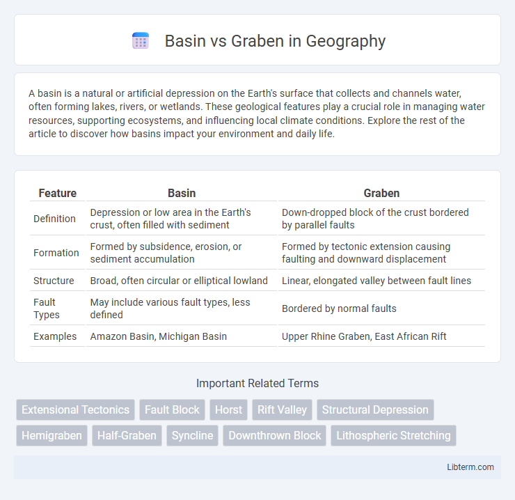
| Feature | Basin | Graben |
|---|---|---|
| Definition | Depression or low area in the Earth's crust, often filled with sediment | Down-dropped block of the crust bordered by parallel faults |
| Formation | Formed by subsidence, erosion, or sediment accumulation | Formed by tectonic extension causing faulting and downward displacement |
| Structure | Broad, often circular or elliptical lowland | Linear, elongated valley between fault lines |
| Fault Types | May include various fault types, less defined | Bordered by normal faults |
| Examples | Amazon Basin, Michigan Basin | Upper Rhine Graben, East African Rift |
Understanding Basins and Grabens: Key Geological Concepts
Basins are structurally depressed regions formed by subsidence often filled with sediment, critical for oil and gas accumulation. Grabens are down-dropped blocks bounded by normal faults, formed through extensional tectonics, representing notable examples of crustal stretching. Understanding the differential formation mechanisms and sedimentary processes in basins versus grabens reveals crucial insights into regional tectonics and resource distribution.
Formation Processes: How Basins and Grabens Develop
Basins form primarily through subsidence caused by sediment accumulation, crustal thinning, or flexural downwarping due to tectonic loading, creating a downward depression that collects sediments over time. Grabens develop through extensional tectonics, where normal faults on opposite sides create a down-dropped block of the crust between them, resulting in a linear valley. Both structures are key indicators of tectonic stresses but differ in their formation mechanisms, with basins often associated with sedimentary processes and grabens directly linked to crustal faulting.
Structural Differences Between Basins and Grabens
Basins are broad, low-lying geological depressions formed primarily by subsidence and sediment accumulation, often exhibiting gentle, outward-dipping strata due to uniform crustal sagging. Grabens are elongated, narrow blocks of the Earth's crust that have dropped down relative to surrounding blocks along parallel normal faults, characterized by steep fault-bounded escarpments and significant tectonic extension. The primary structural difference lies in basins being more uniform and sediment-filled depressions caused by broad crustal downwarping, whereas grabens represent active fault-bounded rift structures formed through crustal stretching and fault displacement.
Tectonic Settings: Where Basins and Grabens Occur
Basins typically develop in tectonic settings characterized by subsidence due to sediment loading, thermal cooling, or flexural response to orogenic loading, commonly found in passive margin zones and intracratonic regions. Grabens form primarily in extensional tectonic environments where crustal stretching causes normal faults, resulting in down-dropped blocks between parallel faults, frequently observed in continental rift zones and divergent plate boundaries. Both structures indicate significant crustal deformation but differ in their formation mechanisms and geological contexts.
Types of Basins and Grabens in Geology
Sedimentary basins, such as forearc, intracratonic, and rift basins, form due to subsidence and sediment accumulation, each characterized by unique tectonic settings and sedimentary processes. Grabens are elongated, down-dropped blocks bounded by normal faults, commonly found in extensional tectonic regimes like rift valleys and continental crust regions experiencing crustal thinning. Both features play critical roles in basin and range topography, controlling patterns of sediment deposition and influencing hydrocarbon reservoir systems.
Notable Global Examples of Basins and Grabens
The Michigan Basin in North America and the Persian Gulf Basin in the Middle East are notable examples of sedimentary basins characterized by their broad, bowl-shaped depressions filled with thick sequences of sedimentary layers. The East African Rift Valley, a prominent graben system, extends over thousands of kilometers and is a classic example of tectonic rifting where crustal extension has created linear troughs bounded by normal faults. The Rhine Graben in Europe highlights a smaller but well-studied graben formed by crustal subsidence and faulting, integral to understanding continental rift dynamics.
Sedimentation Patterns in Basins vs. Grabens
Basins typically exhibit widespread sediment accumulation with thick, continuous layers due to stable subsidence and efficient sediment supply. Grabens, formed by extensional tectonics, present more localized and variable sedimentation patterns characterized by abrupt facies changes and increased coarse-grained deposits from rapid erosion of adjacent uplifted blocks. Sedimentary sequences in grabens often include syntectonic deposits that record active fault movement, contrasting with the more stratified and homogenous sediment layers commonly found in broader basin settings.
Economic Significance: Resources in Basins and Grabens
Basins often contain thick sedimentary deposits rich in hydrocarbons, making them prime targets for oil and natural gas exploration, while grabens, characterized by crustal extension, can also host significant mineral deposits like copper and gold. These geological structures influence groundwater reservoirs and geothermal energy potential, contributing to their economic importance in resource extraction industries. Understanding the distribution of resources in basins and grabens guides investment decisions in energy and mining sectors.
Geophysical Methods for Studying Basins and Grabens
Geophysical methods for studying basins and grabens primarily include seismic reflection and refraction surveys, gravity measurements, and magnetotellurics, which provide detailed subsurface structural imaging and stratigraphic information. Seismic techniques help delineate fault boundaries and sediment thickness within grabens, while gravity surveys detect density variations indicative of basin fill and tectonic activity. Magnetotelluric methods complement these by mapping electrical resistivity contrasts, revealing fluid content and lithology variations crucial for understanding basin and graben formation processes.
Environmental and Seismic Implications of Basins and Grabens
Basins and grabens significantly influence environmental conditions by shaping groundwater flow, sedimentation patterns, and ecosystem distribution due to their subsidence and faulting characteristics. Seismically, grabens are associated with active normal faulting, increasing the risk of earthquakes and ground deformation, while basins may amplify seismic waves due to sediment accumulation, intensifying shaking during seismic events. Understanding the distinct structural and sedimentary properties of basins and grabens is crucial for assessing seismic hazards and managing natural resources in tectonically active regions.
Basin Infographic