Map layers organize geographic data into distinct visual categories, allowing users to analyze information such as roads, terrain, and landmarks with precision. Each layer can be toggled on or off to customize the map's display, enhancing your ability to interpret spatial relationships and patterns effectively. Explore the rest of the article to discover how map layers can transform your mapping experience.
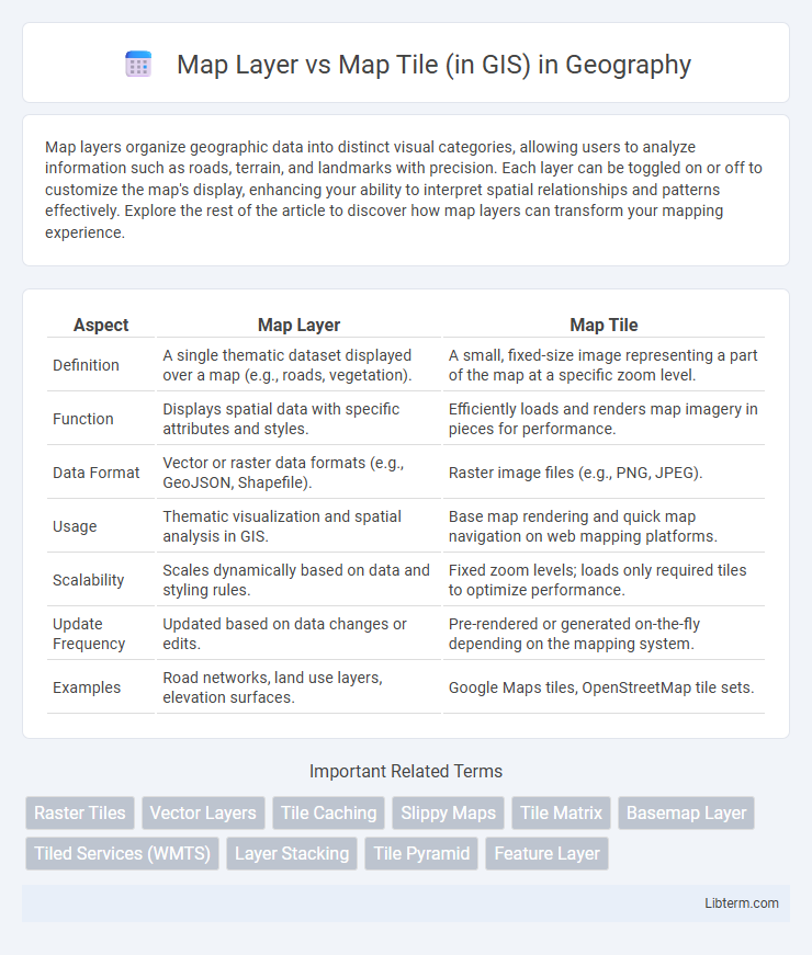
Table of Comparison
| Aspect | Map Layer | Map Tile |
|---|---|---|
| Definition | A single thematic dataset displayed over a map (e.g., roads, vegetation). | A small, fixed-size image representing a part of the map at a specific zoom level. |
| Function | Displays spatial data with specific attributes and styles. | Efficiently loads and renders map imagery in pieces for performance. |
| Data Format | Vector or raster data formats (e.g., GeoJSON, Shapefile). | Raster image files (e.g., PNG, JPEG). |
| Usage | Thematic visualization and spatial analysis in GIS. | Base map rendering and quick map navigation on web mapping platforms. |
| Scalability | Scales dynamically based on data and styling rules. | Fixed zoom levels; loads only required tiles to optimize performance. |
| Update Frequency | Updated based on data changes or edits. | Pre-rendered or generated on-the-fly depending on the mapping system. |
| Examples | Road networks, land use layers, elevation surfaces. | Google Maps tiles, OpenStreetMap tile sets. |
Understanding Map Layers in GIS
Map layers in GIS represent distinct datasets or thematic information such as roads, land use, or elevation, displayed over a geographical base map to provide contextual insight. They are composed of vectors (points, lines, polygons) or raster data, enabling spatial analysis and visualization tailored to specific geographic features. Understanding map layers is essential for effective GIS data management, as they allow users to overlay multiple data types and perform functions like querying, editing, and spatial modeling.
What Are Map Tiles?
Map tiles are small, square images that collectively form a comprehensive map when arranged in a grid, enabling efficient loading and rendering in GIS applications. Each tile corresponds to a specific geographic area and zoom level, allowing for seamless map navigation and faster data retrieval. Utilizing map tiles reduces server load and enhances performance compared to rendering entire map layers dynamically.
Key Differences Between Map Layers and Map Tiles
Map layers in GIS represent thematic data sets such as roads, land use, or elevation, displayed as vector or raster formats, allowing for customizable visualization and analysis. Map tiles are pre-rendered, fixed-size image segments optimized for fast web map loading and seamless panning at multiple zoom levels, usually generated from various map layers. Unlike map layers which are dynamic and editable, map tiles serve as static visual outputs designed to enhance performance and user experience in web mapping applications.
The Role of Map Layers in Spatial Analysis
Map layers serve as fundamental components in spatial analysis by organizing geographic data into distinct thematic categories such as land use, elevation, and hydrology, enabling targeted examination and overlay operations. Each map layer contains spatial features with attribute data, allowing analysts to perform queries, measure relationships, and identify patterns effectively. Unlike map tiles, which are pre-rendered images optimized for fast map display, map layers retain vector or raster data essential for dynamic analysis and decision-making in Geographic Information Systems (GIS).
How Map Tiles Enhance GIS Performance
Map tiles enhance GIS performance by breaking large maps into smaller, pre-rendered image chunks, enabling rapid loading and smooth zooming at various scales. This tiled approach reduces server load and bandwidth usage, allowing efficient data streaming and faster rendering compared to loading entire map layers at once. As a result, users experience seamless interaction with extensive spatial data, improving the overall responsiveness and scalability of GIS applications.
Use Cases: When to Use Map Layers vs Map Tiles
Map layers are ideal for dynamic spatial analysis and thematic mapping where attribute data and real-time updates are essential, such as in environmental monitoring and urban planning. Map tiles offer optimal performance for fast rendering and seamless zooming in large-scale web maps or mobile applications, supporting extensive base maps like OpenStreetMap or satellite imagery. Choosing between map layers and map tiles depends on whether interactive data manipulation or efficient visualization across multiple zoom levels is the primary requirement.
Data Management: Layers vs Tiles
Map layers in GIS organize spatial data into thematic categories such as roads, land use, or elevation, enabling easy management, analysis, and visualization of specific data types. Map tiles are pre-rendered square images that display map data at various zoom levels, optimizing performance by loading only the visible sections. While layers offer detailed, editable vector or raster data for comprehensive analysis, tiles provide fast, scalable map rendering ideal for web mapping applications.
Rendering and Visualization: Comparing Both Approaches
Map layers in GIS represent distinct datasets such as roads, land use, or elevation, rendered dynamically to allow flexible styling and real-time data updates. Map tiles are pre-rendered raster images divided into small, fixed-size squares that enable fast, efficient visualization by loading only relevant tiles during zoom and pan operations. Rendering with map layers offers high customization and interactivity, while map tiles prioritize speed and scalability, making them ideal for large-scale web mapping applications.
Challenges in Integrating Map Layers and Tiles
Integrating map layers and map tiles in GIS presents challenges such as differing resolutions and coordinate systems, which complicate precise alignment and seamless overlay. Variations in data formats and update frequencies create synchronization issues, impacting real-time rendering and user experience. Efficient caching and server performance optimization remain critical for handling large tile sets alongside dynamic layer updates without latency or data inconsistency.
Choosing the Right Approach for Your GIS Project
Map layers in GIS represent distinct datasets such as roads, elevation, or land use, providing detailed attribute information essential for precise spatial analysis. Map tiles are pre-rendered image segments optimized for fast web map visualization, ideal for efficient map display at multiple scales but with limited interactivity. Selecting the right approach depends on project needs: choose map layers for in-depth data manipulation and analysis, or map tiles for rapid, scalable map rendering in user-facing applications.
Map Layer Infographic