Fluvial processes shape landscapes through the movement of rivers and streams, transporting sediment and carving valleys. Understanding fluvial dynamics is crucial for managing water resources, preventing erosion, and mitigating flood risks. Discover how these natural watercourses influence your environment by exploring the full article.
Table of Comparison
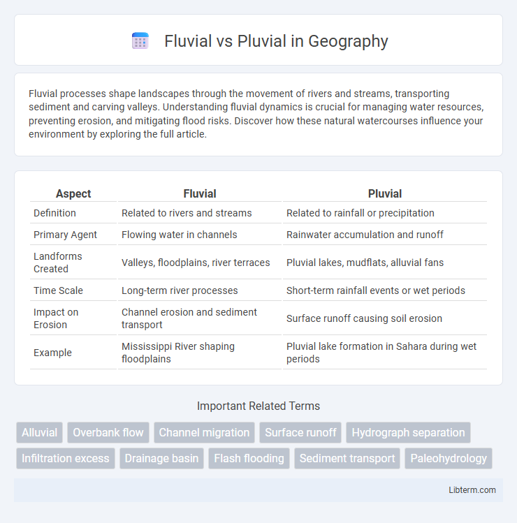
| Aspect | Fluvial | Pluvial |
|---|---|---|
| Definition | Related to rivers and streams | Related to rainfall or precipitation |
| Primary Agent | Flowing water in channels | Rainwater accumulation and runoff |
| Landforms Created | Valleys, floodplains, river terraces | Pluvial lakes, mudflats, alluvial fans |
| Time Scale | Long-term river processes | Short-term rainfall events or wet periods |
| Impact on Erosion | Channel erosion and sediment transport | Surface runoff causing soil erosion |
| Example | Mississippi River shaping floodplains | Pluvial lake formation in Sahara during wet periods |
Understanding Fluvial and Pluvial Flooding
Fluvial flooding occurs when rivers or streams overflow their banks due to excessive rainfall or snowmelt, causing water to spread across adjacent lands. Pluvial flooding results from intense rainfall overwhelming urban drainage systems, leading to surface water accumulation independent of river or stream overflow. Understanding the distinct causes and behaviors of fluvial and pluvial flooding is essential for effective flood risk management and urban planning.
Key Differences Between Fluvial and Pluvial Events
Fluvial events are primarily caused by river or stream overflow due to excessive rainfall or snowmelt, leading to flooding along riverbanks. Pluvial events result from intense rainfall overwhelming surface drainage systems, causing urban or surface flooding without direct involvement of rivers. Key differences include fluvial floods being channel-based with slower onset and potentially longer duration, while pluvial floods occur rapidly on land surfaces, often causing localized and short-term inundation.
Causes of Fluvial Flooding
Fluvial flooding occurs when rivers or streams overflow their banks due to excessive rainfall, rapid snowmelt, or the obstruction of water flow by ice jams or debris accumulation. Intense precipitation upstream or within a watershed increases river discharge beyond channel capacity, causing water to spill onto adjacent floodplains. Land use changes such as deforestation and urbanization reduce soil infiltration, exacerbating runoff and contributing to the likelihood and severity of fluvial floods.
Causes of Pluvial Flooding
Pluvial flooding primarily results from intense rainfall that overwhelms surface drainage systems, causing water to accumulate on land rather than flow into rivers or streams. Urbanization and impermeable surfaces exacerbate pluvial flooding by preventing natural water infiltration into the soil. In contrast, fluvial flooding is caused by rivers and streams exceeding their banks due to sustained heavy rain or snowmelt.
Impacts of Fluvial Floods on Communities
Fluvial floods, caused by river or stream overflow, often result in extensive property damage, disruption of transportation networks, and long-term economic losses for affected communities. These floods increase sediment deposition and pollutant spread, posing significant health risks and damaging infrastructure such as bridges and sewage systems. Emergency response efforts and recovery processes are typically prolonged due to the scale and frequency of fluvial flooding events in floodplain regions.
Pluvial Flooding and Urban Environments
Pluvial flooding occurs when intense rainfall overwhelms urban drainage systems, causing surface water to accumulate rapidly in streets and low-lying areas. Urban environments are particularly vulnerable due to impermeable surfaces like asphalt and concrete that prevent natural infiltration, exacerbating runoff and flood risks. Effective management strategies include enhancing green infrastructure, such as permeable pavements and rain gardens, to improve water absorption and reduce pluvial flood impacts.
Mapping and Monitoring Fluvial vs Pluvial Risks
Mapping and monitoring fluvial versus pluvial risks involve distinct hydrological data and spatial analysis techniques to accurately assess flood hazards from rivers and rainfall-driven surface runoff. Fluvial risk mapping relies on river discharge measurements, floodplain topography, and historical river flood extents, while pluvial risk mapping focuses on urban drainage capacity, rainfall intensity, and surface runoff patterns. Combining satellite imagery, GIS technology, and real-time sensor networks enhances the precision of risk models, enabling targeted flood management strategies for both fluvial and pluvial environments.
Mitigation Strategies for Fluvial and Pluvial Floods
Mitigation strategies for fluvial floods emphasize the construction of levees, river channel modifications, and the restoration of natural floodplains to absorb excess water. Pluvial flood mitigation relies on enhancing urban drainage systems, implementing permeable surfaces, and creating retention basins to manage surface water runoff effectively. Both approaches benefit from integrated watershed management and real-time monitoring systems to reduce flood risks and improve emergency response.
Climate Change Effects on Fluvial and Pluvial Flooding
Climate change intensifies fluvial flooding by increasing river discharge through more frequent heavy rainfall and rapid snowmelt events, leading to higher flood peaks and prolonged inundation. Pluvial flooding escalates as urbanization combines with intense, short-duration rainfall exceeding drainage capacities, causing surface water overflows and localized damage. Both types of flooding are exacerbated by warmer temperatures, which amplify atmospheric moisture content and increase storm intensity, complicating flood risk management strategies.
Future Perspectives in Flood Management
Future perspectives in flood management emphasize integrating fluvial and pluvial flood prediction models using advanced AI and remote sensing technologies to enhance early warning systems. Climate change projections indicate increased frequency of both riverine (fluvial) and surface water (pluvial) flooding, necessitating adaptive infrastructure resilient to extreme hydrological variability. Urban planning increasingly incorporates green infrastructure and permeable surfaces to mitigate pluvial flood risks while reinforcing levees and floodplains addresses fluvial flood challenges effectively.
Fluvial Infographic