The globe symbolizes the interconnectedness of our world, highlighting diverse cultures, environments, and economies shaping global dynamics. Understanding the significance of the globe can enhance your awareness of international relations, trade, and environmental issues affecting humanity. Explore the article to discover how the concept of the globe impacts your daily life and decisions.
Table of Comparison
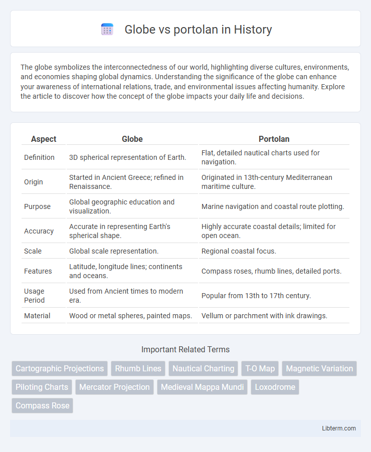
| Aspect | Globe | Portolan |
|---|---|---|
| Definition | 3D spherical representation of Earth. | Flat, detailed nautical charts used for navigation. |
| Origin | Started in Ancient Greece; refined in Renaissance. | Originated in 13th-century Mediterranean maritime culture. |
| Purpose | Global geographic education and visualization. | Marine navigation and coastal route plotting. |
| Accuracy | Accurate in representing Earth's spherical shape. | Highly accurate coastal details; limited for open ocean. |
| Scale | Global scale representation. | Regional coastal focus. |
| Features | Latitude, longitude lines; continents and oceans. | Compass roses, rhumb lines, detailed ports. |
| Usage Period | Used from Ancient times to modern era. | Popular from 13th to 17th century. |
| Material | Wood or metal spheres, painted maps. | Vellum or parchment with ink drawings. |
Introduction to Globes and Portolans
Globes and portolans serve as essential tools in navigation and geography, offering distinct representations of the Earth. Globes provide a three-dimensional, accurate scale model of the world, visually depicting continents, oceans, and latitude-longitude grids for precise spatial orientation. Portolans, originating in the medieval period, are flat, detailed nautical charts marked with compass roses and rhumb lines, designed for practical maritime navigation along coastlines.
Historical Development of Globe Maps
Globe maps originated in ancient Greece, with the earliest known terrestrial globe created by Crates of Mallus in the 2nd century BCE, representing a three-dimensional model of Earth. Portolan charts emerged in the 13th century as highly detailed nautical maps used by Mediterranean mariners, characterized by compass roses and rhumb lines rather than the spherical accuracy of globe maps. The historical development of globe maps evolved through the Renaissance, incorporating advancements in cartography and astronomy, eventually providing a more accurate and holistic visualization of the planet compared to the flat, navigational-focused portolan charts.
The Emergence of Portolan Charts
Portolan charts emerged in the late 13th century as highly detailed navigational maps used by Mediterranean mariners, characterized by their rhumb lines and accurate coastal outlines unlike the spherical representation of globes. These charts provided practical, flat visual guides for sea voyages, enabling precise route plotting along coastlines with pinpointed ports and harbor information, surpassing the less functional globes for maritime navigation. Portolan charts revolutionized nautical cartography by focusing on real-world usability with a network of compass roses and distance scales, directly influencing early modern exploration and trade routes.
Key Differences: Globe vs. Portolan
Globes offer a three-dimensional, accurate representation of Earth's surface, displaying continuous geography and true spatial relationships. Portolans are two-dimensional, detailed navigational maps from the medieval period, featuring compass roses and coastal contours designed for maritime navigation. While globes emphasize global accuracy and scale, portolans prioritize practical route plotting and coastal features for sailors.
Navigational Uses of Globes
Globes serve as accurate three-dimensional models of the Earth, allowing navigators to visualize global positions, distances, and directions in a realistic manner that flat Portolan charts cannot replicate. They facilitate understanding of the curvature of the Earth, aiding in plotting great-circle routes which are the shortest paths between two points on the globe, essential for long-distance navigation. Unlike Portolan charts that emphasize coastal details and compass roses for coastal navigation, globes provide comprehensive spatial orientation crucial for global maritime and aerial navigation.
Maritime Influence of Portolan Charts
Portolan charts, originating in the 13th century, revolutionized maritime navigation with their detailed coastal outlines and accurate placement of ports based on compass directions and distances. Unlike globes, which provided a three-dimensional representation of the world, portolans offered practical, flat maps essential for sailors to plot courses across the Mediterranean and Atlantic with unprecedented precision. These charts significantly influenced the Age of Discovery by enhancing navigational safety and efficiency in sea travel.
Artistic and Scientific Features
Portolan charts exhibit precise coastal details and compass rose markings, reflecting early nautical exploration's practical and scientific focus. Globes present a three-dimensional, artistic representation of the Earth with geographic accuracy enhanced by cartographers' craftsmanship. The globe's spherical form facilitates spatial understanding of global geography, whereas portolans excel in detailed navigational data for maritime routes.
Accuracy and Limitations Compared
Globes offer high accuracy in representing Earth's three-dimensional shape, preserving true scale and spatial relationships without distortion, unlike portolans, which are flat navigational charts based on compass directions and coastal landmarks. Portolan maps provide practical utility for medieval sailors by detailing coastlines and ports but suffer from distortions away from maritime routes and lack precise scale consistency. While globes excel in geographic accuracy, their size and portability limit usability compared to the functional, yet less accurate, portolan charts for navigation.
Impact on Exploration and Trade
Globes provided explorers with a more accurate, three-dimensional representation of the Earth, enhancing navigation by depicting latitude and longitude lines, which improved long-distance sea voyages. Portolan charts, detailed coastal maps with precise compass directions, were indispensable for coastal navigation and trade, facilitating safer and more efficient routes across the Mediterranean and Atlantic. The combination of globes' global perspective and portolans' practical coastal details revolutionized exploration and expanded international trade networks during the Age of Discovery.
Legacy in Modern Cartography
Globes served as three-dimensional representations of Earth, offering a comprehensive view of geographic relationships that influenced early explorers and educators. Portolan charts featured detailed coastal outlines and navigational lines, revolutionizing maritime navigation with their precision during the Age of Discovery. The legacy of both tools endures in modern cartography through digital globes and advanced nautical charts, which blend spatial accuracy with interactive technology to enhance geographic understanding.
Globe Infographic