Glacial landscapes form through the slow movement of ice, sculpting valleys and depositing unique sediments that reveal Earth's climatic history. These massive bodies of ice influence global sea levels and ecosystems, making their patterns essential for environmental studies. Discover how glacial activity continues to shape our planet and why understanding it matters for Your future.
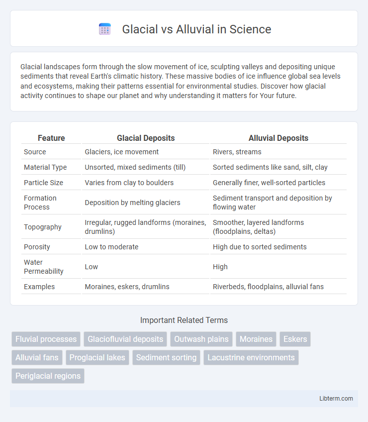
Table of Comparison
| Feature | Glacial Deposits | Alluvial Deposits |
|---|---|---|
| Source | Glaciers, ice movement | Rivers, streams |
| Material Type | Unsorted, mixed sediments (till) | Sorted sediments like sand, silt, clay |
| Particle Size | Varies from clay to boulders | Generally finer, well-sorted particles |
| Formation Process | Deposition by melting glaciers | Sediment transport and deposition by flowing water |
| Topography | Irregular, rugged landforms (moraines, drumlins) | Smoother, layered landforms (floodplains, deltas) |
| Porosity | Low to moderate | High due to sorted sediments |
| Water Permeability | Low | High |
| Examples | Moraines, eskers, drumlins | Riverbeds, floodplains, alluvial fans |
Introduction to Glacial and Alluvial Processes
Glacial processes involve the movement of ice masses that erode, transport, and deposit sediments, shaping landscapes through mechanisms like plucking and abrasion. Alluvial processes refer to the transportation and deposition of sediments by flowing water in rivers and streams, creating landforms such as floodplains and deltas. Understanding these processes is critical for interpreting sedimentary environments and reconstructing past climatic and geomorphological conditions.
Formation of Glacial Landscapes
Glacial landscapes form through the movement and melting of glaciers, which sculpt the earth by erosion, transportation, and deposition of sediment. Glaciers create distinctive landforms such as U-shaped valleys, moraines, drumlins, and fjords by grinding bedrock and depositing till as they advance and retreat. In contrast, alluvial landscapes develop from sediment carried and deposited by river systems, resulting in features like floodplains, deltas, and alluvial fans.
Characteristics of Alluvial Landforms
Alluvial landforms are primarily characterized by the deposition of sediments transported by rivers and streams, resulting in features such as floodplains, levees, and deltas. These landforms typically consist of well-sorted, stratified sediments like sand, silt, and clay, which create fertile soil ideal for agriculture. The dynamic nature of alluvial processes constantly reshapes these landscapes through sediment accumulation and erosion during seasonal floods.
Sediment Types: Glacial vs Alluvial Deposits
Glacial deposits primarily consist of unsorted sediments containing a mixture of clay, silt, sand, gravel, and boulders known as till, which is directly deposited by melting glaciers. Alluvial deposits are well-sorted sediments such as sand, silt, and clay, laid down by flowing water in rivers and streams, often forming layered and stratified structures. The composition and sorting of glacial sediments reflect mechanical weathering and deposition by ice, while alluvial sediments indicate transport and sorting by water flow.
Erosional Features: Glacial and Alluvial Comparison
Glacial erosion sculpts landscapes through processes like plucking and abrasion, creating distinctive U-shaped valleys, fjords, and striations on bedrock surfaces. Alluvial erosion, driven by water flow in rivers and streams, shapes V-shaped valleys, river terraces, and floodplains through sediment transport and deposition. The contrast between glacial and alluvial erosional features highlights the dominance of ice in carving rugged terrain versus water's role in continuously reshaping softer sedimentary environments.
Distribution and Examples Around the World
Glacial deposits are primarily found in regions previously covered by ice sheets, such as Canada's Laurentide Ice Sheet area and parts of Scandinavia, characterized by unsorted till and moraines. Alluvial deposits occur along river valleys and floodplains worldwide, with notable examples including the Nile Delta in Egypt and the Ganges-Brahmaputra basin in India and Bangladesh, where sediments are sorted by water action. Glacial landscapes typically feature drumlins and eskers, while alluvial environments show extensive sediment layering and fertile soils supporting agriculture.
Soil Development in Glacial and Alluvial Areas
Soil development in glacial areas is characterized by poorly sorted, coarse materials deposited directly by ice, leading to shallow, nutrient-poor soils with limited organic matter accumulation. In contrast, alluvial soils form from fine sediments deposited by flowing water, resulting in well-sorted, fertile soils with higher moisture retention and enhanced nutrient cycling. These differences influence vegetation types, agricultural potential, and land management practices in glacial versus alluvial regions.
Ecological Impact of Glacial and Alluvial Systems
Glacial systems create unique habitats through processes like erosion and sediment deposition, supporting cold-adapted species and influencing freshwater ecosystems with nutrient-rich meltwater. Alluvial systems shape fertile floodplains and wetlands, promoting biodiversity by providing dynamic habitats for aquatic and terrestrial species. Both systems play critical roles in maintaining ecological balance, with glacial systems regulating water flow and alluvial systems enhancing soil fertility and habitat complexity.
Human Utilization and Challenges
Glacial deposits, rich in minerals and often containing sand and gravel, are extensively exploited for construction materials, road building, and water filtration systems, but their uneven distribution poses extraction challenges. Alluvial deposits, concentrated along riverbeds and floodplains, support agriculture through fertile soil and provide valuable resources like gold and sedimentary minerals, yet face issues like flooding and environmental degradation from over-extraction. Both deposit types demand sustainable management to balance economic benefits with the risks of landscape alteration, resource depletion, and ecological impact.
Key Differences Between Glacial and Alluvial Processes
Glacial processes involve the movement of ice sheets and glaciers that erode and transport large volumes of rock and sediment through mechanisms like plucking and abrasion, resulting in landforms such as moraines, drumlins, and U-shaped valleys. In contrast, alluvial processes are driven by flowing water, particularly rivers and streams, that deposit sediments like sand, silt, and clay to form features such as alluvial fans, floodplains, and river terraces. The key differences lie in the agents of transport--ice versus water--and the resulting sediment characteristics, with glacial deposits typically being unsorted and angular, while alluvial deposits are more sorted and rounded due to water's selective transport capacity.
Glacial Infographic