Meridians are imaginary lines on the Earth's surface running from the North Pole to the South Pole, used to measure longitude and help determine time zones. Understanding how meridians function is essential for navigation, geography, and global communication. Explore the rest of the article to discover how meridians impact your daily life and the world around you.
Table of Comparison
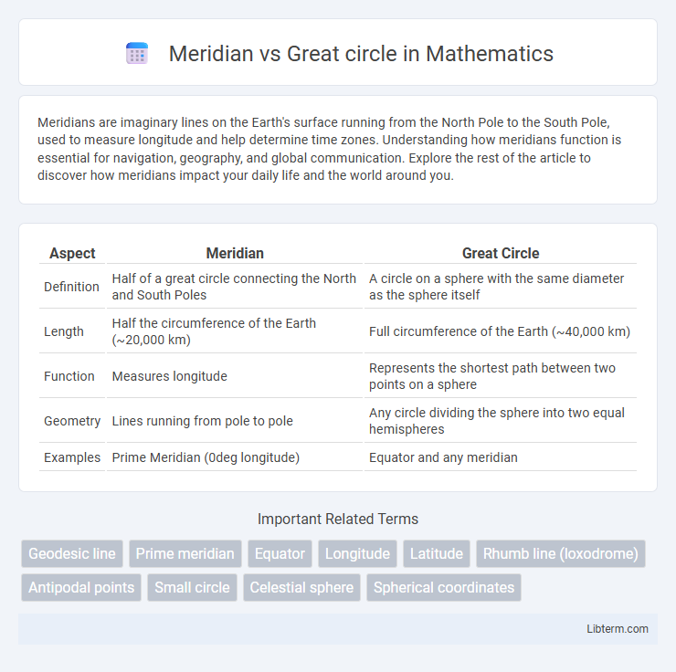
| Aspect | Meridian | Great Circle |
|---|---|---|
| Definition | Half of a great circle connecting the North and South Poles | A circle on a sphere with the same diameter as the sphere itself |
| Length | Half the circumference of the Earth (~20,000 km) | Full circumference of the Earth (~40,000 km) |
| Function | Measures longitude | Represents the shortest path between two points on a sphere |
| Geometry | Lines running from pole to pole | Any circle dividing the sphere into two equal hemispheres |
| Examples | Prime Meridian (0deg longitude) | Equator and any meridian |
Introduction to Meridians and Great Circles
Meridians are imaginary lines running from the North Pole to the South Pole, used to measure longitude and define time zones. Great circles represent the largest possible circles on a sphere, formed by the intersection of the sphere with a plane passing through its center, providing the shortest path between two points on Earth. Understanding the distinction between meridians and great circles is fundamental in navigation and geography.
Definitions: Meridian vs Great Circle
A meridian is a longitudinal line running from the North Pole to the South Pole, representing a constant longitude on Earth's surface. A great circle is any circle on a sphere whose center coincides with the center of the sphere, dividing it into two equal hemispheres and representing the shortest path between two points. While all meridians are great circles, only the equator qualifies as a great circle among latitude lines.
Geographical Importance of Meridians
Meridians are imaginary lines running from the North Pole to the South Pole, essential for determining longitude and providing a framework for time zones and navigation. Unlike great circles, which represent the shortest path between two points on a globe, meridians converge at the poles and are fundamental in mapping, global positioning systems (GPS), and geographic information systems (GIS). Their geographical importance lies in enabling precise location measurement and contributing to Earth's coordinate system for accurate spatial analysis.
Role of Great Circles in Navigation
Great circles represent the shortest path between two points on the Earth's surface, making them essential for navigation and efficient route planning in aviation and maritime travel. Unlike meridians, which run from pole to pole and aid in determining longitude, great circles provide optimal courses that minimize distance and fuel consumption. Navigational systems rely on great circle calculations to chart precise and cost-effective trajectories across long distances.
Key Differences Between Meridians and Great Circles
Meridians are half-circles running from the North Pole to the South Pole, dividing the Earth into equal longitudinal segments, while great circles are the largest possible circles that can be drawn on a sphere, representing the shortest path between two points. Every meridian forms a great circle when paired with its opposite meridian, but individual meridians alone are half the circumference of the Earth, unlike full great circles. Great circles are primarily used in navigation and aviation for plotting the most efficient routes, whereas meridians serve as essential reference lines for geographic coordinate systems.
Examples of Meridians and Great Circles on Earth
The Prime Meridian, located at 0deg longitude, and the 180th meridian form key examples of meridians used for dividing Earth into Eastern and Western Hemispheres. The Equator serves as the most significant great circle, representing 0deg latitude and dividing Earth into Northern and Southern Hemispheres. Other great circles include the Tropics of Cancer and Capricorn, which mark Earth's limits of solar declination during solstices.
Significance in Cartography and Mapmaking
Meridians, or lines of longitude, are crucial in cartography as they facilitate the navigation and precise location positioning by running from the North Pole to the South Pole. Great circles, representing the shortest distance between two points on a sphere, are fundamental for accurate route plotting and minimizing distortions in map projections. Understanding the difference between meridians and great circles enables cartographers to improve navigation charts and optimize global spatial data representation.
Applications in Aviation and Maritime Routes
Meridian lines serve as essential reference points for longitude in aviation and maritime navigation, aiding in accurate positioning and course plotting. Great circles represent the shortest distance between two points on a sphere, making their routes critical for optimizing fuel efficiency and reducing travel time in both air and sea transportation. Airlines and shipping companies extensively rely on great circle calculations to plan efficient, cost-effective paths across the globe.
Historical Perspectives and Discoveries
Meridian lines have been fundamental in early celestial navigation, representing the imaginary lines running from the North Pole to the South Pole used by ancient astronomers for timekeeping and geographic orientation. Great circles, including the equator and meridians, emerged as essential concepts in the Age of Exploration for defining the shortest path between two points on a sphere, revolutionizing maritime travel and cartography. Historical discoveries by explorers like Ferdinand Magellan utilized great circle routes to optimize voyages, highlighting the evolution from using solely meridian-based navigation to integrating spherical geometry for global exploration.
Summary: Choosing Between Meridians and Great Circles
Meridians are lines of longitude running from the North to South Pole, used primarily for navigation and timekeeping with consistent reference points along Earth's surface. Great circles represent the shortest path between two points on a sphere, essential for plotting efficient air and sea routes. Choosing between meridians and great circles depends on purpose: meridians aid in fixed coordinate systems, while great circles optimize travel distance and fuel consumption.
Meridian Infographic