Latitude measures your position north or south of the Equator, expressed in degrees. It plays a critical role in climate, time zones, and navigation across the globe. Discover how understanding latitude can enhance your knowledge of geography and map reading in the rest of this article.
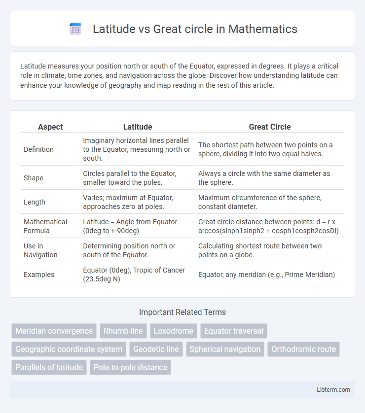
Table of Comparison
| Aspect | Latitude | Great Circle |
|---|---|---|
| Definition | Imaginary horizontal lines parallel to the Equator, measuring north or south. | The shortest path between two points on a sphere, dividing it into two equal halves. |
| Shape | Circles parallel to the Equator, smaller toward the poles. | Always a circle with the same diameter as the sphere. |
| Length | Varies; maximum at Equator, approaches zero at poles. | Maximum circumference of the sphere, constant diameter. |
| Mathematical Formula | Latitude = Angle from Equator (0deg to +-90deg) | Great circle distance between points: d = r x arccos(sinph1sinph2 + cosph1cosph2cosDl) |
| Use in Navigation | Determining position north or south of the Equator. | Calculating shortest route between two points on a globe. |
| Examples | Equator (0deg), Tropic of Cancer (23.5deg N) | Equator, any meridian (e.g., Prime Meridian) |
Introduction to Latitude and Great Circles
Latitude is a geographic coordinate that specifies the north-south position of a point on Earth's surface, measured in degrees from the Equator. Great circles represent the shortest path between two points on a sphere and are formed by any circle whose center coincides with the center of the Earth. Unlike latitude lines, which run parallel and measure angular distance from the Equator, great circles include the Equator and all meridians, serving as fundamental references in navigation and geodesy.
Defining Latitude: Basic Concepts
Latitude represents angular measurements north or south of the Equator, expressed in degrees from 0deg at the Equator to 90deg at the poles. Great circle routes are the shortest paths between two points on a sphere, following the curvature of the Earth. Understanding latitude is fundamental for navigation and mapping, as it establishes a grid system that intersects with longitude to precisely define locations on the globe.
Understanding Great Circles: An Overview
Great circles represent the shortest path between two points on a sphere, unlike latitude lines which are parallel and do not reflect the shortest distance. Understanding great circles is essential in navigation and aviation for plotting efficient routes across the Earth's curved surface. These circles pass through the planet's center, making them fundamental in geodesy and global positioning systems (GPS).
Geometric Differences: Latitude Lines vs. Great Circles
Latitude lines, also known as parallels, are geometric circles parallel to the Equator, maintaining a constant angle relative to the Earth's rotational axis but shrinking in circumference toward the poles. Great circles, such as the Equator and meridians, represent the largest possible circles on a sphere, dividing the Earth into equal halves and providing the shortest distance between two points. The key geometric difference lies in latitude lines being smaller, parallel circles, whereas great circles encompass the Earth's full circumference.
Role in Navigation: Latitude vs. Great Circle Routes
Latitude lines run east-west and provide a consistent reference for determining north-south position, essential for plotting straight, constant-angle courses on navigational charts. Great circle routes represent the shortest distance between two points on a sphere, often curving relative to latitude lines, enabling more efficient long-distance travel by minimizing fuel consumption and time. Navigators use latitude for basic positional awareness while relying on great circle calculations for optimizing route efficiency in air and sea navigation.
Applications in Geography and Cartography
Latitude lines run parallel to the Equator and are crucial for defining climate zones and navigation at specific latitudinal positions, helping geographers identify regions with similar environmental conditions. Great circles represent the shortest path between two points on the Earth's surface, extensively used in air and sea navigation for plotting efficient routes. Cartographers rely on great circle calculations to create accurate maps and globe representations, while latitude provides a consistent framework for dividing the Earth into horizontal coordinate bands.
Earth’s Measurement: Calculating Distances
Latitude lines are parallel circles measuring distances north or south of the Equator, making them useful for approximating distances along east-west routes. Great circle routes represent the shortest distance between two points on Earth's surface, following a path along a circle whose center coincides with Earth's center. Calculating distances using great circles is essential for accurate navigation and air travel, as it accounts for Earth's spherical shape rather than relying on flat, latitude-based measurements.
Real-World Examples: Practical Uses
Latitude lines help pilots and sailors maintain consistent navigation by providing a constant angular distance from the equator, essential for plotting routes across oceans and continents. Great circle routes represent the shortest distance between two points on the earth's surface, widely used in aviation to minimize fuel consumption and flight time on long-haul flights such as New York to Tokyo or London to Sydney. Shipping companies leverage these routes for efficient maritime navigation, optimizing transit times and reducing operational costs on transoceanic journeys.
Common Misconceptions Explained
Latitude lines are often confused with great circles, but only the Equator qualifies as a great circle because it divides the Earth into two equal hemispheres. Other latitude lines, known as parallels, are smaller circles that run east-west and do not represent the shortest path between two points. Understanding this distinction is crucial for accurate navigation and geospatial analysis.
Conclusion: Key Takeaways and Comparison
Latitude lines run parallel to the equator and measure distance north or south, while great circle routes represent the shortest path between two points on a sphere. Great circle navigation is crucial for optimizing long-distance travel and minimizing fuel consumption in aviation and maritime routes. Understanding the distinction between these concepts enhances route planning accuracy and efficiency in global navigation.
Latitude Infographic